|
|
|||||||||||||||||
| Point ID: 3678 | Downloads | Plots | Site Data | Code: 10PC003 |
|
|
|||||||||||||||||
| Download | |
|---|---|
| Site Descriptor Information | Site Time Series Data |
| Link to all available data | |

|

|
| View: | Statistics | Time Series |
| Units: | mm |
| Statistic | Jan | Feb | Mar | Apr | May | Jun | Jul | Aug | Sep | Oct | Nov | Dec | Annual |
|---|---|---|---|---|---|---|---|---|---|---|---|---|---|
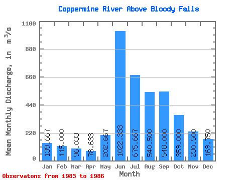
| Mean | 139.67 | 115.00 | 96.03 | 78.63 | 202.67 | 1022.33 | 675.67 | 540.50 | 548.00 | 359.00 | 230.50 | 169.75 | 337.69 |
| Standard Deviation | 17.79 | 15.72 | 13.86 | 10.37 | 99.62 | 419.98 | 152.43 | 119.37 | 179.56 | 81.86 | 71.31 | 36.79 | 21.19 |
| Min | 124.00 | 104.00 | 87.10 | 72.40 | 115.00 | 711.00 | 500.00 | 432.00 | 339.00 | 245.00 | 164.00 | 131.00 | 314.67 |
| Max | 159.00 | 133.00 | 112.00 | 90.60 | 311.00 | 1500.00 | 773.00 | 700.00 | 775.00 | 439.00 | 325.00 | 216.00 | 356.38 |
| Coefficient of Variation | 0.13 | 0.14 | 0.14 | 0.13 | 0.49 | 0.41 | 0.23 | 0.22 | 0.33 | 0.23 | 0.31 | 0.22 | 0.06 |
| Year | Jan | Feb | Mar | Apr | May | Jun | Jul | Aug | Sep | Oct | Nov | Dec | Annual | 1983 | 469.00 | 775.00 | 439.00 | 325.00 | 216.00 | 1984 | 159.00 | 133.00 | 112.00 | 90.60 | 182.00 | 856.00 | 754.00 | 700.00 | 565.00 | 384.00 | 189.00 | 152.00 | 356.38 | 1985 | 124.00 | 104.00 | 87.10 | 72.90 | 311.00 | 711.00 | 500.00 | 561.00 | 513.00 | 368.00 | 244.00 | 180.00 | 314.67 | 1986 | 136.00 | 108.00 | 89.00 | 72.40 | 115.00 | 1500.00 | 773.00 | 432.00 | 339.00 | 245.00 | 164.00 | 131.00 | 342.03 |
|---|
 Return to R-Arctic Net Home Page