|
|
|||||||||||||||||
| Point ID: 3655 | Downloads | Plots | Site Data | Code: 10LC006 |
|
|
|||||||||||||||||
| Download | |
|---|---|
| Site Descriptor Information | Site Time Series Data |
| Link to all available data | |
|
|
| View: | Statistics | Time Series |
| Units: | mm |
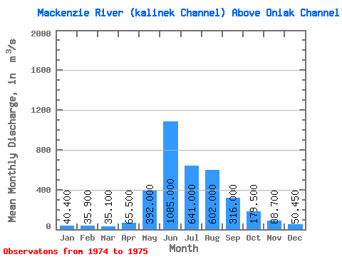
| Statistic | Jan | Feb | Mar | Apr | May | Jun | Jul | Aug | Sep | Oct | Nov | Dec | Annual |
|---|---|---|---|---|---|---|---|---|---|---|---|---|---|
| Mean | 40.40 | 35.90 | 35.10 | 65.50 | 392.00 | 1085.00 | 641.00 | 602.00 | 316.00 | 179.50 | 88.70 | 50.45 | 248.18 |
| Standard Deviation | 91.92 | 111.72 | 326.68 | 110.31 | 64.35 | 55.58 | 22.13 | ||||||
| Min | 40.40 | 35.90 | 35.10 | 65.50 | 392.00 | 1020.00 | 562.00 | 371.00 | 238.00 | 134.00 | 49.40 | 34.80 | 248.18 |
| Max | 40.40 | 35.90 | 35.10 | 65.50 | 392.00 | 1150.00 | 720.00 | 833.00 | 394.00 | 225.00 | 128.00 | 66.10 | 248.18 |
| Coefficient of Variation | 0.09 | 0.17 | 0.54 | 0.35 | 0.36 | 0.63 | 0.44 |
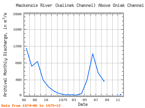
| Year | Jan | Feb | Mar | Apr | May | Jun | Jul | Aug | Sep | Oct | Nov | Dec | Annual | 1974 | 1150.00 | 720.00 | 833.00 | 394.00 | 225.00 | 128.00 | 66.10 | 1975 | 40.40 | 35.90 | 35.10 | 65.50 | 392.00 | 1020.00 | 562.00 | 371.00 | 238.00 | 134.00 | 49.40 | 34.80 | 248.18 |
|---|
 Return to R-Arctic Net Home Page