|
|
|||||||||||||||||
| Point ID: 3647 | Downloads | Plots | Site Data | Code: 10KB001 |
|
|
|||||||||||||||||
| Download | |
|---|---|
| Site Descriptor Information | Site Time Series Data |
| Link to all available data | |
|
|
| View: | Statistics | Time Series |
| Units: | mm |
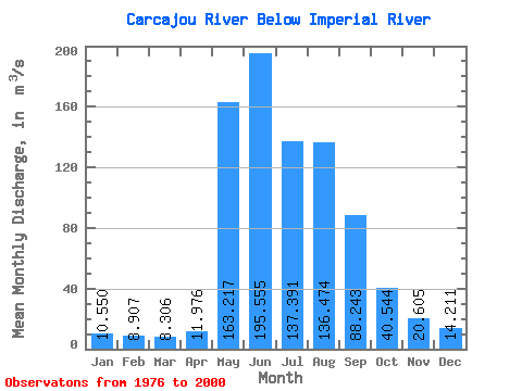
| Statistic | Jan | Feb | Mar | Apr | May | Jun | Jul | Aug | Sep | Oct | Nov | Dec | Annual |
|---|---|---|---|---|---|---|---|---|---|---|---|---|---|
| Mean | 10.55 | 8.91 | 8.31 | 11.98 | 163.22 | 195.56 | 137.39 | 136.47 | 88.24 | 40.54 | 20.61 | 14.21 | 69.63 |
| Standard Deviation | 2.52 | 2.63 | 2.46 | 5.24 | 58.21 | 86.67 | 59.22 | 65.85 | 31.97 | 12.24 | 3.98 | 2.68 | 17.48 |
| Min | 6.60 | 5.72 | 4.79 | 6.07 | 80.80 | 46.60 | 47.80 | 56.50 | 38.70 | 21.60 | 14.10 | 9.81 | 38.09 |
| Max | 15.50 | 14.20 | 12.40 | 29.50 | 301.00 | 338.00 | 266.00 | 295.00 | 166.00 | 61.50 | 27.50 | 18.00 | 94.52 |
| Coefficient of Variation | 0.24 | 0.29 | 0.30 | 0.44 | 0.36 | 0.44 | 0.43 | 0.48 | 0.36 | 0.30 | 0.19 | 0.19 | 0.25 |
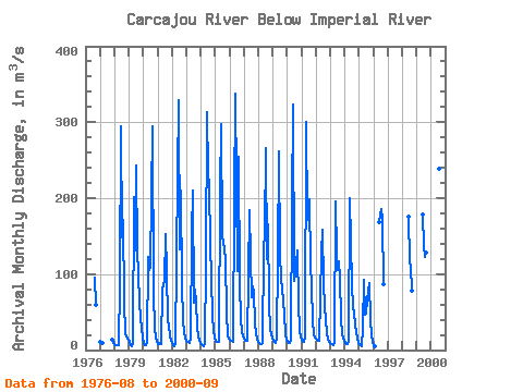
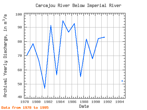
| Year | Jan | Feb | Mar | Apr | May | Jun | Jul | Aug | Sep | Oct | Nov | Dec | Annual | 1976 | 95.40 | 58.80 | 1977 | 10.50 | 9.77 | 9.06 | 14.10 | 10.00 | 1978 | 7.93 | 6.42 | 5.80 | 6.07 | 87.10 | 295.00 | 148.00 | 172.00 | 62.60 | 21.60 | 18.30 | 14.20 | 70.42 | 1979 | 10.30 | 5.81 | 4.84 | 8.14 | 202.00 | 131.00 | 243.00 | 128.00 | 102.00 | 60.30 | 27.50 | 17.00 | 78.32 | 1980 | 8.53 | 6.77 | 7.06 | 9.92 | 122.00 | 105.00 | 110.00 | 295.00 | 74.40 | 28.20 | 17.20 | 12.40 | 66.37 | 1981 | 8.55 | 8.82 | 8.32 | 8.33 | 80.80 | 90.60 | 152.00 | 104.00 | 38.70 | 31.90 | 18.60 | 12.90 | 46.96 | 1982 | 8.80 | 6.38 | 5.18 | 7.92 | 230.00 | 329.00 | 133.00 | 210.00 | 85.60 | 39.70 | 23.60 | 15.50 | 91.22 | 1983 | 11.50 | 10.20 | 10.00 | 17.10 | 152.00 | 210.00 | 62.60 | 79.10 | 63.80 | 29.30 | 18.80 | 12.40 | 56.40 | 1984 | 8.16 | 5.89 | 5.26 | 9.67 | 114.00 | 313.00 | 234.00 | 215.00 | 141.00 | 46.70 | 24.40 | 17.10 | 94.52 | 1985 | 12.60 | 10.90 | 10.30 | 11.30 | 210.00 | 298.00 | 150.00 | 133.00 | 118.00 | 49.70 | 19.20 | 15.20 | 86.52 | 1986 | 13.80 | 12.90 | 11.70 | 10.90 | 195.00 | 338.00 | 104.00 | 255.00 | 86.70 | 42.20 | 23.30 | 18.00 | 92.62 | 1987 | 14.80 | 12.90 | 11.60 | 12.30 | 184.00 | 123.00 | 69.90 | 84.00 | 75.00 | 35.60 | 22.60 | 15.70 | 55.12 | 1988 | 10.90 | 8.50 | 7.80 | 9.61 | 132.00 | 154.00 | 266.00 | 120.00 | 166.00 | 61.30 | 27.10 | 17.20 | 81.70 | 1989 | 12.40 | 10.50 | 10.00 | 15.10 | 121.00 | 262.00 | 125.00 | 94.50 | 81.70 | 46.50 | 20.90 | 14.30 | 67.83 | 1990 | 11.10 | 9.68 | 9.21 | 11.50 | 192.00 | 323.00 | 91.20 | 99.80 | 131.00 | 61.50 | 26.10 | 17.20 | 81.94 | 1991 | 13.00 | 11.20 | 10.30 | 16.40 | 301.00 | 172.00 | 199.00 | 114.00 | 84.40 | 38.80 | 19.40 | 16.60 | 83.01 | 1992 | 15.50 | 14.20 | 12.40 | 11.90 | 127.00 | 159.00 | 86.70 | 58.60 | 39.10 | 22.60 | 15.20 | 11.20 | 47.78 | 1993 | 8.80 | 7.40 | 6.76 | 9.61 | 195.00 | 127.00 | 106.00 | 117.00 | 94.80 | 41.90 | 20.90 | 12.80 | 62.33 | 1994 | 9.65 | 8.05 | 7.43 | 10.30 | 200.00 | 143.00 | 85.40 | 56.50 | 49.00 | 32.60 | 15.20 | 9.81 | 52.24 | 1995 | 7.57 | 6.13 | 4.79 | 29.50 | 93.00 | 46.60 | 47.80 | 65.00 | 87.70 | 39.40 | 19.10 | 10.50 | 38.09 | 1996 | 6.60 | 5.72 | 168.00 | 185.00 | 172.00 | 86.20 | 1998 | 176.00 | 117.00 | 110.00 | 78.80 | 1999 | 179.00 | 137.00 | 122.00 | 128.00 | 2000 | 160.00 | 170.00 | 239.00 | 96.30 |
|---|
 Return to R-Arctic Net Home Page