|
|
|||||||||||||||||
| Point ID: 3634 | Downloads | Plots | Site Data | Code: 10HC006 |
|
|
|||||||||||||||||
| Download | |
|---|---|
| Site Descriptor Information | Site Time Series Data |
| Link to all available data | |
|
|
| View: | Statistics | Time Series |
| Units: | mm |
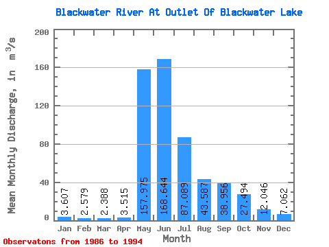
| Statistic | Jan | Feb | Mar | Apr | May | Jun | Jul | Aug | Sep | Oct | Nov | Dec | Annual |
|---|---|---|---|---|---|---|---|---|---|---|---|---|---|
| Mean | 3.61 | 2.58 | 2.39 | 3.52 | 157.97 | 168.64 | 87.09 | 43.59 | 38.96 | 27.49 | 12.05 | 7.06 | 46.09 |
| Standard Deviation | 2.32 | 1.69 | 1.47 | 2.34 | 72.23 | 86.14 | 83.41 | 25.15 | 40.56 | 23.64 | 8.02 | 4.61 | 16.21 |
| Min | 0.11 | 0.01 | 0.05 | 0.12 | 84.40 | 69.60 | 31.80 | 14.10 | 6.95 | 6.89 | 3.35 | 1.70 | 21.43 |
| Max | 6.64 | 4.76 | 4.30 | 8.46 | 270.00 | 344.00 | 300.00 | 76.20 | 124.00 | 72.20 | 22.90 | 14.90 | 69.82 |
| Coefficient of Variation | 0.64 | 0.66 | 0.61 | 0.67 | 0.46 | 0.51 | 0.96 | 0.58 | 1.04 | 0.86 | 0.67 | 0.65 | 0.35 |
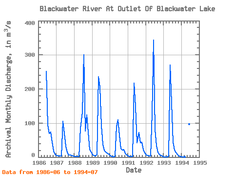
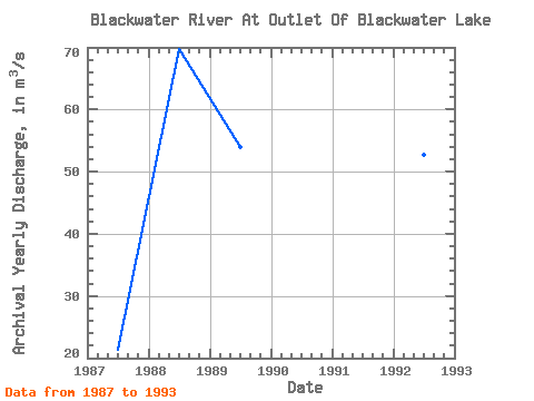
| Year | Jan | Feb | Mar | Apr | May | Jun | Jul | Aug | Sep | Oct | Nov | Dec | Annual | 1986 | 252.00 | 93.60 | 69.70 | 73.30 | 43.30 | 18.60 | 7.81 | 1987 | 5.30 | 3.56 | 3.09 | 3.10 | 105.00 | 69.60 | 31.80 | 14.10 | 6.95 | 6.89 | 4.56 | 3.21 | 21.43 | 1988 | 2.78 | 2.47 | 2.32 | 2.63 | 84.40 | 133.00 | 300.00 | 76.20 | 124.00 | 72.20 | 22.90 | 14.90 | 69.82 | 1989 | 6.64 | 4.76 | 4.06 | 8.46 | 236.00 | 206.00 | 93.00 | 37.30 | 18.70 | 15.30 | 10.50 | 7.83 | 54.05 | 1990 | 2.93 | 1.68 | 1.33 | 2.99 | 89.40 | 110.00 | 63.70 | 24.60 | 20.10 | 22.50 | 10.40 | 6.38 | 29.67 | 1991 | 3.62 | 2.72 | 2.75 | 2.81 | 217.00 | 149.00 | 42.30 | 72.10 | 41.80 | 44.30 | 21.70 | 11.90 | 51.00 | 1992 | 6.21 | 4.57 | 4.30 | 4.13 | 128.00 | 344.00 | 80.70 | 33.30 | 13.50 | 7.23 | 4.36 | 2.77 | 52.76 | 1993 | 1.27 | 0.86 | 1.20 | 3.88 | 270.00 | 158.00 | 44.00 | 21.40 | 13.30 | 8.23 | 3.35 | 1.70 | 43.93 | 1994 | 0.11 | 0.01 | 0.05 | 0.12 | 134.00 | 96.20 | 34.70 |
|---|
 Return to R-Arctic Net Home Page