|
|
|||||||||||||||||
| Point ID: 3628 | Downloads | Plots | Site Data | Code: 10HB001 |
|
|
|||||||||||||||||
| Download | |
|---|---|
| Site Descriptor Information | Site Time Series Data |
| Link to all available data | |
|
|
| View: | Statistics | Time Series |
| Units: | mm |
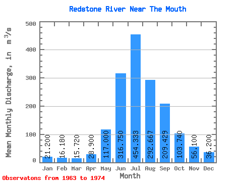
| Statistic | Jan | Feb | Mar | Apr | May | Jun | Jul | Aug | Sep | Oct | Nov | Dec | Annual |
|---|---|---|---|---|---|---|---|---|---|---|---|---|---|
| Mean | 21.20 | 16.18 | 15.72 | 28.90 | 117.00 | 316.75 | 454.33 | 292.67 | 209.43 | 103.74 | 56.10 | 36.20 | |
| Standard Deviation | 11.41 | 6.45 | 5.71 | 10.61 | 79.94 | 88.12 | 83.51 | 55.98 | 18.02 | 15.34 | 11.68 | ||
| Min | 12.50 | 11.30 | 12.00 | 21.40 | 117.00 | 263.00 | 369.00 | 197.00 | 153.00 | 84.60 | 47.80 | 24.00 | |
| Max | 38.00 | 27.40 | 25.80 | 36.40 | 117.00 | 435.00 | 545.00 | 351.00 | 308.00 | 124.00 | 79.10 | 51.30 | |
| Coefficient of Variation | 0.54 | 0.40 | 0.36 | 0.37 | 0.25 | 0.19 | 0.28 | 0.27 | 0.17 | 0.27 | 0.32 |
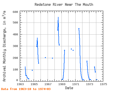
| Year | Jan | Feb | Mar | Apr | May | Jun | Jul | Aug | Sep | Oct | Nov | Dec | Annual | 1963 | 124.00 | 49.10 | 51.30 | 1964 | 38.00 | 27.40 | 25.80 | 21.40 | 94.60 | 1965 | 295.00 | 369.00 | 197.00 | 153.00 | 1966 | 201.00 | 1967 | 197.00 | 1968 | 435.00 | 545.00 | 330.00 | 308.00 | 1969 | 15.60 | 14.20 | 36.40 | 117.00 | 263.00 | 1970 | 274.00 | 263.00 | 1971 | 449.00 | 351.00 | 173.00 | 93.50 | 47.80 | 24.00 | 1972 | 12.50 | 11.30 | 12.00 | 171.00 | 84.60 | 48.40 | 31.00 | 1973 | 16.90 | 13.30 | 14.00 | 122.00 | 79.10 | 38.50 | 1974 | 17.40 | 13.30 | 12.60 |
|---|
 Return to R-Arctic Net Home Page