|
|
|||||||||||||||||
| Point ID: 3618 | Downloads | Plots | Site Data | Code: 10GA001 |
|
|
|||||||||||||||||
| Download | |
|---|---|
| Site Descriptor Information | Site Time Series Data |
| Link to all available data | |
|
|
| View: | Statistics | Time Series |
| Units: | mm |
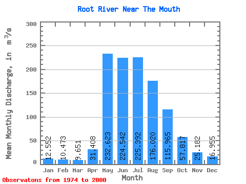
| Statistic | Jan | Feb | Mar | Apr | May | Jun | Jul | Aug | Sep | Oct | Nov | Dec | Annual |
|---|---|---|---|---|---|---|---|---|---|---|---|---|---|
| Mean | 12.55 | 10.47 | 9.65 | 31.41 | 232.62 | 224.54 | 225.39 | 176.02 | 115.97 | 57.82 | 25.18 | 16.95 | 92.35 |
| Standard Deviation | 4.96 | 4.16 | 3.53 | 25.46 | 98.17 | 117.37 | 131.31 | 93.45 | 55.25 | 20.13 | 8.80 | 6.74 | 30.26 |
| Min | 3.31 | 4.45 | 2.51 | 2.60 | 74.70 | 37.00 | 70.30 | 64.70 | 55.70 | 34.20 | 10.60 | 4.10 | 54.75 |
| Max | 22.70 | 20.20 | 18.40 | 86.20 | 451.00 | 556.00 | 658.00 | 401.00 | 286.00 | 109.00 | 50.30 | 29.40 | 159.60 |
| Coefficient of Variation | 0.40 | 0.40 | 0.37 | 0.81 | 0.42 | 0.52 | 0.58 | 0.53 | 0.48 | 0.35 | 0.35 | 0.40 | 0.33 |
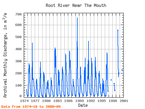
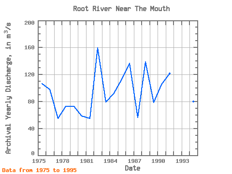
| Year | Jan | Feb | Mar | Apr | May | Jun | Jul | Aug | Sep | Oct | Nov | Dec | Annual | 1974 | 66.20 | 25.80 | 18.30 | 1975 | 12.40 | 9.50 | 8.57 | 18.30 | 198.00 | 280.00 | 206.00 | 267.00 | 129.00 | 109.00 | 29.40 | 13.20 | 106.70 | 1976 | 12.30 | 10.40 | 8.83 | 42.80 | 451.00 | 146.00 | 158.00 | 141.00 | 103.00 | 73.90 | 17.50 | 9.47 | 97.85 | 1977 | 8.51 | 8.48 | 7.99 | 9.26 | 121.00 | 153.00 | 145.00 | 79.30 | 65.20 | 39.80 | 13.20 | 6.24 | 54.75 | 1978 | 5.63 | 5.44 | 4.89 | 6.34 | 126.00 | 200.00 | 292.00 | 106.00 | 56.50 | 37.20 | 18.60 | 11.10 | 72.47 | 1979 | 8.23 | 4.45 | 2.51 | 2.60 | 210.00 | 133.00 | 196.00 | 161.00 | 88.90 | 50.60 | 10.60 | 4.10 | 72.67 | 1980 | 3.31 | 4.46 | 6.67 | 51.70 | 123.00 | 70.00 | 127.00 | 143.00 | 90.80 | 51.60 | 22.20 | 10.10 | 58.65 | 1981 | 8.73 | 8.24 | 8.03 | 15.50 | 163.00 | 105.00 | 138.00 | 64.70 | 56.50 | 52.20 | 24.40 | 17.10 | 55.12 | 1982 | 8.82 | 8.56 | 8.64 | 9.15 | 368.00 | 410.00 | 249.00 | 401.00 | 286.00 | 106.00 | 34.50 | 25.50 | 159.60 | 1983 | 14.20 | 11.40 | 10.90 | 13.60 | 227.00 | 217.00 | 102.00 | 209.00 | 72.30 | 38.00 | 18.20 | 13.10 | 78.89 | 1984 | 8.66 | 6.47 | 5.99 | 14.60 | 74.70 | 223.00 | 253.00 | 202.00 | 203.00 | 68.10 | 21.90 | 15.80 | 91.44 | 1985 | 15.00 | 13.90 | 10.80 | 8.42 | 361.00 | 336.00 | 245.00 | 167.00 | 96.30 | 54.80 | 22.80 | 20.80 | 112.65 | 1986 | 18.10 | 14.80 | 12.40 | 17.40 | 386.00 | 365.00 | 248.00 | 307.00 | 148.00 | 69.50 | 28.10 | 23.60 | 136.49 | 1987 | 19.80 | 16.30 | 13.60 | 32.00 | 151.00 | 111.00 | 99.50 | 92.40 | 77.80 | 34.50 | 17.90 | 11.90 | 56.48 | 1988 | 10.50 | 8.84 | 8.36 | 86.20 | 213.00 | 269.00 | 658.00 | 169.00 | 134.00 | 49.30 | 38.70 | 22.30 | 138.93 | 1989 | 10.20 | 6.89 | 6.58 | 63.40 | 250.00 | 252.00 | 114.00 | 82.00 | 59.80 | 43.20 | 31.80 | 21.00 | 78.41 | 1990 | 14.90 | 11.90 | 11.00 | 50.40 | 200.00 | 247.00 | 112.00 | 326.00 | 171.00 | 63.60 | 27.70 | 21.40 | 104.74 | 1991 | 16.10 | 14.60 | 14.60 | 76.10 | 274.00 | 154.00 | 465.00 | 141.00 | 147.00 | 78.10 | 50.30 | 29.40 | 121.68 | 1992 | 22.70 | 20.20 | 18.40 | 18.60 | 325.00 | 272.00 | 279.00 | 96.80 | 57.00 | 34.20 | 23.20 | 16.20 | 98.61 | 1993 | 10.30 | 8.10 | 8.37 | 24.00 | 273.00 | 332.00 | 167.00 | 213.00 | 116.00 | 62.40 | 31.00 | 27.20 | 106.03 | 1994 | 18.50 | 13.40 | 12.80 | 40.00 | 199.00 | 176.00 | 218.00 | 75.80 | 110.00 | 52.60 | 26.10 | 20.90 | 80.26 | 1995 | 16.70 | 13.60 | 12.10 | 75.40 | 154.00 | 37.00 | 70.30 | 137.00 | 89.30 | 43.10 | 20.10 | 14.30 | 56.91 | 1996 | 10.30 | 15.20 | 270.00 | 150.00 | 369.00 | 351.00 | 125.00 | 51.90 | 1997 | 145.00 | 1998 | 113.00 | 73.50 | 55.70 | 1999 | 556.00 | 295.00 | 169.00 | 201.00 | 2000 | 195.00 | 316.00 | 226.00 | 131.00 |
|---|
 Return to R-Arctic Net Home Page