|
|
|||||||||||||||||
| Point ID: 3608 | Downloads | Plots | Site Data | Code: 10ED005 |
|
|
|||||||||||||||||
| Download | |
|---|---|
| Site Descriptor Information | Site Time Series Data |
| Link to all available data | |
|
|
| View: | Statistics | Time Series |
| Units: | mm |
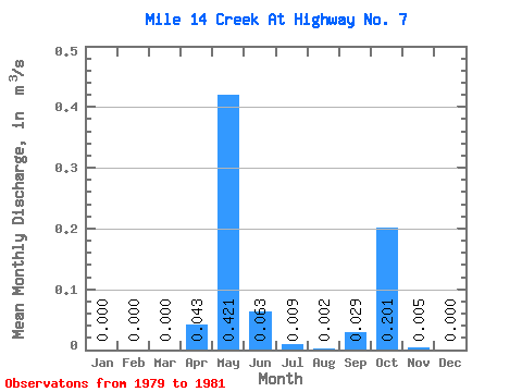
| Statistic | Jan | Feb | Mar | Apr | May | Jun | Jul | Aug | Sep | Oct | Nov | Dec | Annual |
|---|---|---|---|---|---|---|---|---|---|---|---|---|---|
| Mean | 0.00 | 0.00 | 0.00 | 0.04 | 0.42 | 0.06 | 0.01 | 0.00 | 0.03 | 0.20 | 0.01 | 0.00 | 0.07 |
| Standard Deviation | 0.00 | 0.00 | 0.00 | 0.04 | 0.42 | 0.09 | 0.01 | 0.00 | 0.05 | 0.31 | 0.01 | 0.00 | 0.04 |
| Min | 0.00 | 0.00 | 0.00 | 0.00 | 0.03 | 0.01 | 0.00 | 0.00 | 0.00 | 0.02 | 0.00 | 0.00 | 0.01 |
| Max | 0.00 | 0.00 | 0.00 | 0.07 | 0.86 | 0.17 | 0.02 | 0.00 | 0.08 | 0.56 | 0.01 | 0.00 | 0.10 |
| Coefficient of Variation | 0.87 | 0.99 | 1.39 | 0.94 | 1.00 | 1.61 | 1.54 | 1.25 | 0.70 |
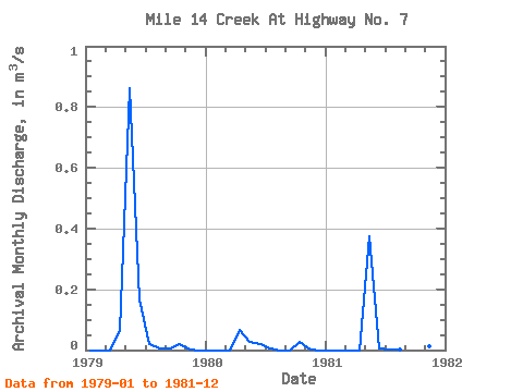
| Year | Jan | Feb | Mar | Apr | May | Jun | Jul | Aug | Sep | Oct | Nov | Dec | Annual | 1979 | 0.00 | 0.00 | 0.00 | 0.06 | 0.86 | 0.17 | 0.02 | 0.00 | 0.00 | 0.02 | 0.00 | 0.00 | 0.10 | 1980 | 0.00 | 0.00 | 0.00 | 0.07 | 0.03 | 0.02 | 0.01 | 0.00 | 0.00 | 0.03 | 0.00 | 0.00 | 0.01 | 1981 | 0.00 | 0.00 | 0.00 | 0.00 | 0.37 | 0.01 | 0.00 | 0.00 | 0.08 | 0.56 | 0.01 | 0.00 | 0.09 |
|---|
 Return to R-Arctic Net Home Page