|
|
|||||||||||||||||
| Point ID: 3607 | Downloads | Plots | Site Data | Code: 10ED004 |
|
|
|||||||||||||||||
| Download | |
|---|---|
| Site Descriptor Information | Site Time Series Data |
| Link to all available data | |
|
|
| View: | Statistics | Time Series |
| Units: | mm |
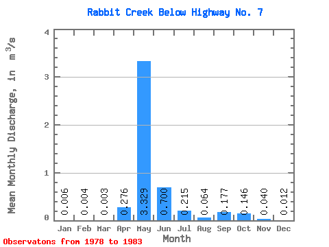
| Statistic | Jan | Feb | Mar | Apr | May | Jun | Jul | Aug | Sep | Oct | Nov | Dec | Annual |
|---|---|---|---|---|---|---|---|---|---|---|---|---|---|
| Mean | 0.01 | 0.00 | 0.00 | 0.28 | 3.33 | 0.70 | 0.21 | 0.06 | 0.18 | 0.15 | 0.04 | 0.01 | 0.41 |
| Standard Deviation | 0.00 | 0.00 | 0.00 | 0.18 | 3.26 | 0.62 | 0.28 | 0.08 | 0.23 | 0.14 | 0.04 | 0.01 | 0.25 |
| Min | 0.00 | 0.00 | 0.00 | 0.03 | 0.09 | 0.01 | 0.01 | 0.01 | 0.01 | 0.02 | 0.01 | 0.00 | 0.21 |
| Max | 0.01 | 0.01 | 0.01 | 0.51 | 9.31 | 1.47 | 0.71 | 0.21 | 0.56 | 0.41 | 0.12 | 0.03 | 0.83 |
| Coefficient of Variation | 0.59 | 0.72 | 1.02 | 0.67 | 0.98 | 0.89 | 1.31 | 1.19 | 1.29 | 0.94 | 1.00 | 0.83 | 0.60 |
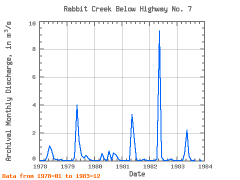
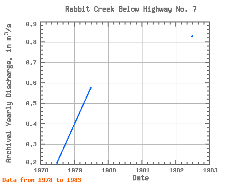
| Year | Jan | Feb | Mar | Apr | May | Jun | Jul | Aug | Sep | Oct | Nov | Dec | Annual | 1978 | 0.01 | 0.01 | 0.01 | 0.26 | 1.05 | 0.77 | 0.14 | 0.08 | 0.05 | 0.09 | 0.02 | 0.01 | 0.21 | 1979 | 0.01 | 0.00 | 0.00 | 0.25 | 4.01 | 1.47 | 0.38 | 0.21 | 0.37 | 0.17 | 0.04 | 0.00 | 0.57 | 1980 | 0.00 | 0.00 | 0.00 | 0.51 | 0.09 | 0.01 | 0.71 | 0.06 | 0.56 | 0.41 | 0.12 | 0.01 | 0.21 | 1981 | 0.01 | 0.01 | 0.00 | 0.03 | 3.32 | 1.40 | 0.04 | 0.01 | 0.01 | 0.08 | 0.04 | 0.03 | 0.41 | 1982 | 0.01 | 0.00 | 0.00 | 0.14 | 9.31 | 0.25 | 0.02 | 0.02 | 0.06 | 0.12 | 0.01 | 0.01 | 0.83 | 1983 | 0.00 | 0.00 | 0.00 | 0.47 | 2.19 | 0.30 | 0.01 | 0.01 | 0.03 | 0.02 | 0.01 | 0.01 | 0.25 |
|---|
 Return to R-Arctic Net Home Page