|
|
|||||||||||||||||
| Point ID: 3599 | Downloads | Plots | Site Data | Code: 10EB001 |
|
|
|||||||||||||||||
| Download | |
|---|---|
| Site Descriptor Information | Site Time Series Data |
| Link to all available data | |
|
|
| View: | Statistics | Time Series |
| Units: | mm |
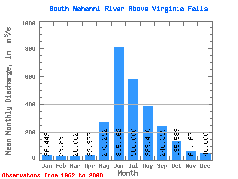
| Statistic | Jan | Feb | Mar | Apr | May | Jun | Jul | Aug | Sep | Oct | Nov | Dec | Annual |
|---|---|---|---|---|---|---|---|---|---|---|---|---|---|
| Mean | 36.44 | 29.89 | 28.06 | 32.98 | 273.25 | 815.16 | 586.00 | 389.41 | 246.36 | 135.59 | 61.17 | 46.60 | 224.78 |
| Standard Deviation | 7.70 | 6.55 | 5.37 | 6.61 | 122.83 | 174.44 | 138.87 | 67.21 | 72.22 | 34.08 | 10.59 | 9.13 | 22.20 |
| Min | 17.40 | 17.60 | 17.40 | 22.30 | 99.80 | 524.00 | 349.00 | 259.00 | 153.00 | 86.10 | 37.90 | 27.70 | 184.97 |
| Max | 53.40 | 40.90 | 40.00 | 51.60 | 552.00 | 1270.00 | 880.00 | 530.00 | 506.00 | 214.00 | 78.90 | 61.90 | 264.96 |
| Coefficient of Variation | 0.21 | 0.22 | 0.19 | 0.20 | 0.45 | 0.21 | 0.24 | 0.17 | 0.29 | 0.25 | 0.17 | 0.20 | 0.10 |
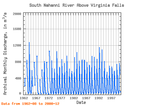
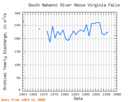
| Year | Jan | Feb | Mar | Apr | May | Jun | Jul | Aug | Sep | Oct | Nov | Dec | Annual | 1962 | 404.00 | 216.00 | 1963 | 753.00 | 840.00 | 455.00 | 424.00 | 198.00 | 76.50 | 36.80 | 1964 | 31.10 | 31.10 | 31.10 | 31.10 | 99.80 | 1270.00 | 691.00 | 507.00 | 233.00 | 132.00 | 67.30 | 55.00 | 264.96 | 1965 | 41.60 | 35.70 | 34.20 | 36.60 | 153.00 | 524.00 | 588.00 | 301.00 | 215.00 | 1966 | 785.00 | 526.00 | 288.00 | 236.00 | 1967 | 936.00 | 560.00 | 361.00 | 231.00 | 133.00 | 55.00 | 28.40 | 1968 | 27.20 | 26.50 | 26.00 | 360.00 | 255.00 | 133.00 | 72.70 | 45.30 | 1969 | 31.60 | 26.60 | 599.00 | 488.00 | 379.00 | 190.00 | 108.00 | 62.70 | 43.30 | 1970 | 38.50 | 34.90 | 31.40 | 29.10 | 271.00 | 816.00 | 715.00 | 420.00 | 221.00 | 154.00 | 59.50 | 35.70 | 235.51 | 1971 | 30.20 | 29.30 | 28.90 | 782.00 | 496.00 | 339.00 | 194.00 | 112.00 | 51.50 | 34.20 | 1972 | 24.60 | 18.80 | 18.50 | 1060.00 | 822.00 | 440.00 | 198.00 | 111.00 | 64.60 | 46.60 | 1973 | 29.40 | 23.50 | 24.10 | 31.00 | 513.00 | 826.00 | 454.00 | 349.00 | 247.00 | 107.00 | 61.50 | 38.30 | 225.32 | 1974 | 27.00 | 22.70 | 21.60 | 23.30 | 172.00 | 627.00 | 443.00 | 481.00 | 227.00 | 88.30 | 42.10 | 44.70 | 184.97 | 1975 | 36.40 | 30.10 | 24.90 | 30.70 | 245.00 | 1050.00 | 713.00 | 306.00 | 245.00 | 172.00 | 56.80 | 43.60 | 246.12 | 1976 | 37.40 | 32.30 | 29.40 | 51.60 | 262.00 | 667.00 | 624.00 | 337.00 | 164.00 | 120.00 | 53.80 | 37.70 | 201.35 | 1977 | 29.80 | 22.40 | 22.60 | 31.90 | 306.00 | 860.00 | 537.00 | 498.00 | 245.00 | 86.10 | 37.90 | 35.60 | 226.03 | 1978 | 34.10 | 31.20 | 27.30 | 23.50 | 190.00 | 762.00 | 693.00 | 382.00 | 169.00 | 130.00 | 75.00 | 45.70 | 213.57 | 1979 | 29.80 | 25.20 | 24.60 | 27.40 | 180.00 | 942.00 | 680.00 | 419.00 | 205.00 | 146.00 | 55.50 | 42.40 | 231.41 | 1980 | 35.80 | 29.40 | 27.20 | 38.30 | 263.00 | 627.00 | 480.00 | 376.00 | 228.00 | 170.00 | 57.30 | 42.40 | 197.87 | 1981 | 36.80 | 27.80 | 26.80 | 30.60 | 477.00 | 568.00 | 417.00 | 282.00 | 216.00 | 122.00 | 51.00 | 49.90 | 192.07 | 1982 | 32.70 | 18.80 | 17.40 | 22.30 | 159.00 | 905.00 | 521.00 | 356.00 | 228.00 | 125.00 | 60.50 | 52.90 | 208.22 | 1983 | 37.30 | 28.40 | 27.90 | 28.50 | 217.00 | 1030.00 | 475.00 | 467.00 | 246.00 | 113.00 | 43.20 | 27.70 | 228.42 | 1984 | 17.40 | 17.60 | 23.20 | 31.40 | 248.00 | 819.00 | 550.00 | 450.00 | 221.00 | 110.00 | 49.10 | 37.60 | 214.53 | 1985 | 30.40 | 17.80 | 17.70 | 26.90 | 168.00 | 828.00 | 848.00 | 399.00 | 203.00 | 103.00 | 51.30 | 39.10 | 227.68 | 1986 | 29.70 | 23.80 | 21.00 | 23.60 | 205.00 | 843.00 | 834.00 | 371.00 | 201.00 | 122.00 | 63.90 | 47.60 | 232.13 | 1987 | 37.10 | 29.00 | 26.10 | 28.00 | 227.00 | 788.00 | 546.00 | 402.00 | 309.00 | 181.00 | 77.40 | 50.10 | 225.06 | 1988 | 41.60 | 37.20 | 33.10 | 40.00 | 387.00 | 718.00 | 701.00 | 402.00 | 341.00 | 202.00 | 78.90 | 46.80 | 252.38 | 1989 | 37.70 | 32.20 | 29.40 | 34.10 | 373.00 | 936.00 | 424.00 | 287.00 | 157.00 | 94.80 | 54.10 | 46.60 | 208.82 | 1990 | 37.70 | 32.60 | 31.10 | 34.40 | 262.00 | 911.00 | 466.00 | 445.00 | 506.00 | 214.00 | 78.70 | 57.30 | 256.32 | 1991 | 48.70 | 40.90 | 36.90 | 43.90 | 395.00 | 866.00 | 656.00 | 401.00 | 308.00 | 145.00 | 74.80 | 61.80 | 256.50 | 1992 | 53.40 | 40.30 | 40.00 | 37.60 | 142.00 | 1150.00 | 880.00 | 379.00 | 199.00 | 96.30 | 59.50 | 51.80 | 260.74 | 1993 | 40.00 | 31.00 | 30.20 | 35.20 | 511.00 | 1090.00 | 544.00 | 315.00 | 262.00 | 157.00 | 52.10 | 54.20 | 260.14 | 1994 | 47.20 | 39.20 | 33.90 | 40.40 | 326.00 | 814.00 | 464.00 | 342.00 | 182.00 | 177.00 | 70.20 | 60.80 | 216.39 | 1995 | 48.80 | 39.60 | 34.30 | 38.00 | 418.00 | 551.00 | 440.00 | 358.00 | 349.00 | 171.00 | 67.00 | 55.00 | 214.14 | 1996 | 42.00 | 35.30 | 28.80 | 31.20 | 210.00 | 701.00 | 592.00 | 450.00 | 354.00 | 120.00 | 60.40 | 50.70 | 222.95 | 1997 | 42.40 | 35.10 | 31.80 | 36.40 | 224.00 | 678.00 | 593.00 | 410.00 | 241.00 | 111.00 | 60.30 | 55.90 | 209.91 | 1998 | 40.80 | 30.80 | 30.90 | 41.80 | 552.00 | 576.00 | 349.00 | 259.00 | 153.00 | 98.70 | 68.70 | 57.10 | 188.15 | 1999 | 43.20 | 30.60 | 28.40 | 34.10 | 165.00 | 740.00 | 454.00 | 480.00 | 294.00 | 140.00 | 60.20 | 57.10 | 210.55 | 2000 | 46.10 | 38.50 | 33.40 | 29.40 | 150.00 | 763.00 | 578.00 | 530.00 | 295.00 | 178.00 | 71.00 | 61.90 | 231.19 |
|---|
 Return to R-Arctic Net Home Page