|
|
|||||||||||||||||
| Point ID: 3597 | Downloads | Plots | Site Data | Code: 10EA003 |
|
|
|||||||||||||||||
| Download | |
|---|---|
| Site Descriptor Information | Site Time Series Data |
| Link to all available data | |
|

|
| View: | Statistics | Time Series |
| Units: | mm |
| Statistic | Jan | Feb | Mar | Apr | May | Jun | Jul | Aug | Sep | Oct | Nov | Dec | Annual |
|---|---|---|---|---|---|---|---|---|---|---|---|---|---|
| Mean | 19.03 | 16.26 | 14.70 | 23.84 | 186.34 | 276.58 | 212.54 | 143.55 | 101.92 | 57.69 | 29.35 | 23.89 | 93.76 |
| Standard Deviation | 3.91 | 3.54 | 3.47 | 11.71 | 43.03 | 76.60 | 68.96 | 39.56 | 29.89 | 16.80 | 8.45 | 5.74 | 15.05 |
| Min | 11.80 | 6.80 | 4.21 | 11.20 | 79.00 | 149.00 | 121.00 | 81.40 | 55.30 | 23.00 | 16.20 | 14.70 | 68.97 |
| Max | 28.60 | 22.70 | 20.90 | 57.00 | 278.00 | 451.00 | 393.00 | 240.00 | 181.00 | 101.00 | 55.40 | 40.50 | 126.42 |
| Coefficient of Variation | 0.20 | 0.22 | 0.24 | 0.49 | 0.23 | 0.28 | 0.32 | 0.28 | 0.29 | 0.29 | 0.29 | 0.24 | 0.16 |
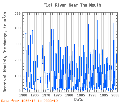
| Year | Jan | Feb | Mar | Apr | May | Jun | Jul | Aug | Sep | Oct | Nov | Dec | Annual | 1960 | 23.00 | 19.30 | 18.10 | 1961 | 17.00 | 15.30 | 14.40 | 364.00 | 153.00 | 95.90 | 77.80 | 43.10 | 22.10 | 22.10 | 1962 | 20.40 | 17.00 | 14.30 | 290.00 | 171.00 | 111.00 | 82.30 | 37.10 | 29.70 | 1963 | 26.60 | 22.70 | 19.80 | 29.00 | 218.00 | 358.00 | 296.00 | 133.00 | 145.00 | 82.40 | 34.50 | 22.10 | 115.59 | 1964 | 20.40 | 19.80 | 19.80 | 19.80 | 384.00 | 213.00 | 175.00 | 113.00 | 58.60 | 33.60 | 28.40 | 1965 | 20.90 | 17.00 | 15.30 | 17.00 | 114.00 | 174.00 | 190.00 | 96.60 | 69.80 | 1966 | 229.00 | 184.00 | 124.00 | 78.50 | 1967 | 89.20 | 62.30 | 1968 | 272.00 | 294.00 | 237.00 | 178.00 | 1969 | 221.00 | 134.00 | 145.00 | 98.30 | 56.30 | 1970 | 118.00 | 92.10 | 65.30 | 29.90 | 17.00 | 1971 | 307.00 | 149.00 | 87.70 | 69.40 | 1972 | 328.00 | 393.00 | 185.00 | 77.10 | 42.20 | 19.70 | 15.00 | 1973 | 13.50 | 10.70 | 8.88 | 15.80 | 253.00 | 393.00 | 158.00 | 101.00 | 128.00 | 35.90 | 19.30 | 16.50 | 96.13 | 1974 | 13.60 | 12.30 | 12.50 | 16.00 | 176.00 | 310.00 | 215.00 | 240.00 | 112.00 | 52.70 | 24.60 | 24.90 | 100.80 | 1975 | 20.20 | 18.10 | 15.10 | 19.70 | 212.00 | 321.00 | 241.00 | 150.00 | 90.50 | 67.30 | 32.80 | 28.20 | 101.33 | 1976 | 22.50 | 17.80 | 14.80 | 30.30 | 278.00 | 257.00 | 250.00 | 174.00 | 105.00 | 57.30 | 27.60 | 20.20 | 104.54 | 1977 | 16.90 | 14.70 | 13.80 | 20.30 | 164.00 | 242.00 | 220.00 | 208.00 | 140.00 | 74.10 | 20.80 | 14.70 | 95.78 | 1978 | 13.30 | 14.50 | 14.90 | 14.50 | 79.00 | 167.00 | 281.00 | 151.00 | 81.90 | 64.30 | 29.70 | 23.00 | 77.84 | 1979 | 18.00 | 14.90 | 14.00 | 15.90 | 192.00 | 287.00 | 248.00 | 149.00 | 135.00 | 50.40 | 22.20 | 19.30 | 97.14 | 1980 | 20.60 | 20.80 | 20.80 | 27.20 | 131.00 | 224.00 | 162.00 | 110.00 | 133.00 | 101.00 | 43.30 | 29.50 | 85.27 | 1981 | 23.10 | 16.90 | 15.70 | 16.70 | 196.00 | 258.00 | 131.00 | 81.40 | 81.30 | 41.60 | 24.50 | 22.50 | 75.72 | 1982 | 17.90 | 14.10 | 12.30 | 12.10 | 176.00 | 298.00 | 121.00 | 130.00 | 63.70 | 34.50 | 23.50 | 22.00 | 77.09 | 1983 | 18.30 | 13.90 | 12.90 | 13.70 | 140.00 | 182.00 | 140.00 | 150.00 | 77.80 | 41.10 | 20.20 | 17.80 | 68.97 | 1984 | 12.60 | 11.50 | 11.70 | 20.10 | 137.00 | 283.00 | 170.00 | 120.00 | 84.80 | 40.10 | 20.10 | 19.50 | 77.53 | 1985 | 14.50 | 11.90 | 11.70 | 15.90 | 187.00 | 219.00 | 193.00 | 102.00 | 70.50 | 43.20 | 16.20 | 14.80 | 74.97 | 1986 | 11.80 | 6.80 | 4.21 | 11.20 | 172.00 | 264.00 | 327.00 | 170.00 | 89.50 | 73.20 | 29.50 | 27.30 | 98.88 | 1987 | 21.70 | 15.70 | 13.80 | 16.80 | 224.00 | 243.00 | 197.00 | 152.00 | 102.00 | 54.10 | 28.20 | 26.20 | 91.21 | 1988 | 21.50 | 17.60 | 15.20 | 21.50 | 199.00 | 426.00 | 350.00 | 172.00 | 124.00 | 74.40 | 55.40 | 40.50 | 126.42 | 1989 | 28.60 | 19.60 | 16.80 | 47.40 | 225.00 | 247.00 | 162.00 | 112.00 | 69.50 | 43.80 | 31.80 | 24.30 | 85.65 | 1990 | 17.80 | 15.80 | 15.40 | 20.10 | 212.00 | 265.00 | 168.00 | 165.00 | 100.00 | 55.50 | 30.50 | 24.10 | 90.77 | 1991 | 21.60 | 22.60 | 15.30 | 57.00 | 236.00 | 234.00 | 263.00 | 146.00 | 139.00 | 70.40 | 41.30 | 32.10 | 106.53 | 1992 | 22.10 | 21.10 | 18.60 | 33.40 | 205.00 | 451.00 | 312.00 | 197.00 | 117.00 | 56.30 | 33.00 | 30.10 | 124.72 | 1993 | 21.40 | 21.40 | 20.90 | 31.80 | 217.00 | 261.00 | 209.00 | 125.00 | 80.20 | 59.10 | 27.80 | 23.10 | 91.47 | 1994 | 18.60 | 16.10 | 17.80 | 49.00 | 195.00 | 265.00 | 144.00 | 115.00 | 104.00 | 72.20 | 32.70 | 28.90 | 88.19 | 1995 | 21.90 | 15.60 | 14.20 | 39.70 | 172.00 | 149.00 | 143.00 | 123.00 | 95.70 | 58.50 | 30.40 | 27.30 | 74.19 | 1996 | 20.40 | 17.30 | 15.40 | 21.80 | 182.00 | 235.00 | 196.00 | 164.00 | 181.00 | 79.30 | 35.50 | 29.20 | 98.08 | 1997 | 15.10 | 13.70 | 8.16 | 15.20 | 144.00 | 164.00 | 106.00 | 44.30 | 23.20 | 24.10 | 1998 | 18.50 | 16.70 | 15.70 | 162.00 | 121.00 | 85.30 | 55.30 | 38.00 | 25.60 | 18.20 | 1999 | 15.30 | 13.90 | 14.30 | 14.30 | 218.00 | 433.00 | 217.00 | 144.00 | 114.00 | 65.70 | 42.80 | 28.80 | 110.09 | 2000 | 21.30 | 18.70 | 16.50 | 32.10 | 150.00 | 244.00 | 229.00 | 184.00 | 124.00 | 75.40 | 38.70 | 26.50 | 96.68 |
|---|
 Return to R-Arctic Net Home Page
