|
|
|||||||||||||||||
| Point ID: 3565 | Downloads | Plots | Site Data | Code: 07PC001 |
|
|
|||||||||||||||||
| Download | |
|---|---|
| Site Descriptor Information | Site Time Series Data |
| Link to all available data | |
|
|
| View: | Statistics | Time Series |
| Units: | mm |
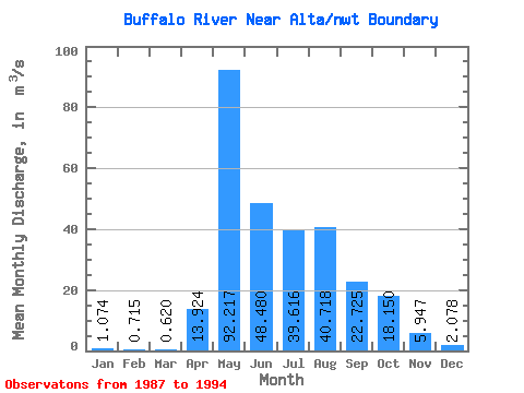
| Statistic | Jan | Feb | Mar | Apr | May | Jun | Jul | Aug | Sep | Oct | Nov | Dec | Annual |
|---|---|---|---|---|---|---|---|---|---|---|---|---|---|
| Mean | 1.07 | 0.71 | 0.62 | 13.92 | 92.22 | 48.48 | 39.62 | 40.72 | 22.73 | 18.15 | 5.95 | 2.08 | 20.94 |
| Standard Deviation | 0.48 | 0.46 | 0.51 | 9.08 | 13.09 | 30.39 | 27.67 | 39.74 | 13.43 | 16.00 | 3.41 | 1.15 | 7.60 |
| Min | 0.49 | 0.22 | 0.06 | 0.87 | 72.90 | 12.00 | 3.78 | 3.39 | 7.35 | 7.79 | 2.93 | 0.70 | 13.31 |
| Max | 1.71 | 1.58 | 1.49 | 30.60 | 110.00 | 95.10 | 73.80 | 97.20 | 45.00 | 45.90 | 12.30 | 3.57 | 31.24 |
| Coefficient of Variation | 0.45 | 0.65 | 0.82 | 0.65 | 0.14 | 0.63 | 0.70 | 0.98 | 0.59 | 0.88 | 0.57 | 0.55 | 0.36 |
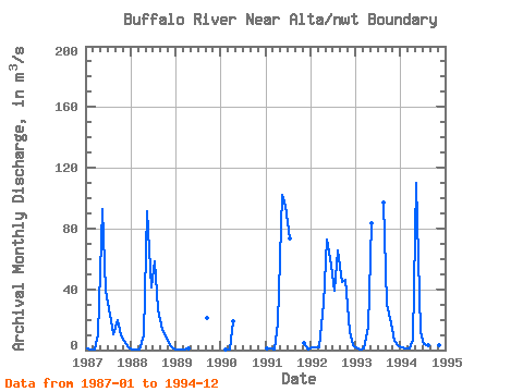
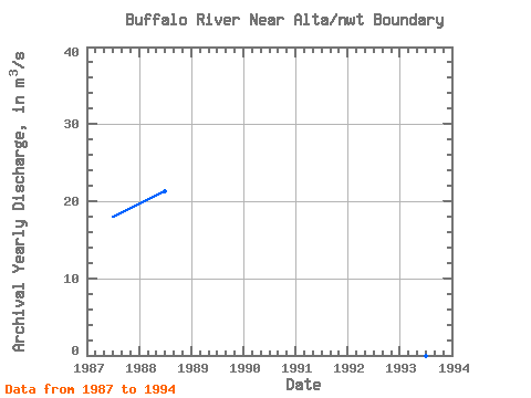
| Year | Jan | Feb | Mar | Apr | May | Jun | Jul | Aug | Sep | Oct | Nov | Dec | Annual | 1987 | 0.82 | 0.46 | 0.25 | 10.10 | 93.00 | 39.20 | 23.40 | 10.40 | 19.40 | 9.90 | 6.44 | 1.86 | 17.94 | 1988 | 0.71 | 0.26 | 0.06 | 9.67 | 91.60 | 40.90 | 58.20 | 26.90 | 13.00 | 9.26 | 3.49 | 1.41 | 21.29 | 1989 | 0.49 | 0.22 | 0.12 | 0.87 | 21.10 | 1990 | 0.57 | 0.43 | 19.20 | 1991 | 0.80 | 1.06 | 0.71 | 18.40 | 102.00 | 95.10 | 73.80 | 4.41 | 0.70 | 1992 | 1.71 | 1.58 | 1.49 | 30.60 | 72.90 | 55.20 | 38.90 | 65.70 | 45.00 | 45.90 | 12.30 | 3.57 | 31.24 | 1993 | 1.41 | 0.58 | 0.74 | 15.40 | 83.80 | 97.20 | 30.50 | 17.90 | 6.11 | 3.39 | 1994 | 1.59 | 0.99 | 1.16 | 7.15 | 110.00 | 12.00 | 3.78 | 3.39 | 7.35 | 7.79 | 2.93 | 1.54 | 13.31 |
|---|
 Return to R-Arctic Net Home Page