|
|
|||||||||||||||||
| Point ID: 3552 | Downloads | Plots | Site Data | Code: 06PA001 |
|
|
|||||||||||||||||
| Download | |
|---|---|
| Site Descriptor Information | Site Time Series Data |
| Link to all available data | |
|

|
| View: | Statistics | Time Series |
| Units: | mm |
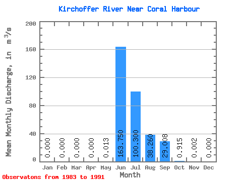
| Statistic | Jan | Feb | Mar | Apr | May | Jun | Jul | Aug | Sep | Oct | Nov | Dec | Annual |
|---|---|---|---|---|---|---|---|---|---|---|---|---|---|
| Mean | 0.00 | 0.00 | 0.00 | 0.00 | 0.01 | 163.75 | 100.30 | 38.26 | 29.01 | 0.92 | 0.00 | 0.00 | 25.76 |
| Standard Deviation | 0.00 | 0.00 | 0.00 | 0.00 | 0.03 | 55.76 | 56.64 | 22.51 | 20.21 | 1.10 | 0.00 | 0.00 | 7.94 |
| Min | 0.00 | 0.00 | 0.00 | 0.00 | 0.00 | 122.00 | 36.80 | 12.20 | 6.94 | 0.12 | 0.00 | 0.00 | 18.84 |
| Max | 0.00 | 0.00 | 0.00 | 0.00 | 0.05 | 246.00 | 186.00 | 71.80 | 60.10 | 2.68 | 0.01 | 0.00 | 34.43 |
| Coefficient of Variation | 2.00 | 0.34 | 0.56 | 0.59 | 0.70 | 1.21 | 2.24 | 0.31 |
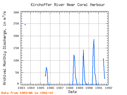
| Year | Jan | Feb | Mar | Apr | May | Jun | Jul | Aug | Sep | Oct | Nov | Dec | Annual | 1983 | 246.00 | 1985 | 0.00 | 36.80 | 71.80 | 60.10 | 2.68 | 0.00 | 0.00 | 1988 | 0.00 | 0.00 | 0.00 | 0.00 | 0.00 | 122.00 | 110.00 | 33.50 | 21.40 | 1.33 | 0.00 | 0.00 | 24.02 | 1989 | 0.00 | 0.00 | 0.00 | 0.00 | 0.00 | 143.00 | 63.70 | 12.20 | 6.94 | 0.25 | 0.01 | 0.00 | 18.84 | 1990 | 0.00 | 0.00 | 0.00 | 0.00 | 0.05 | 144.00 | 186.00 | 46.80 | 36.10 | 0.20 | 0.00 | 0.00 | 34.43 | 1991 | 105.00 | 27.00 | 20.50 | 0.12 | 0.00 | 0.00 |
|---|
 Return to R-Arctic Net Home Page