|
|
|||||||||||||||||
| Point ID: 3544 | Downloads | Plots | Site Data | Code: 06NB002 |
|
|
|||||||||||||||||
| Download | |
|---|---|
| Site Descriptor Information | Site Time Series Data |
| Link to all available data | |
|
|
| View: | Statistics | Time Series |
| Units: | mm |
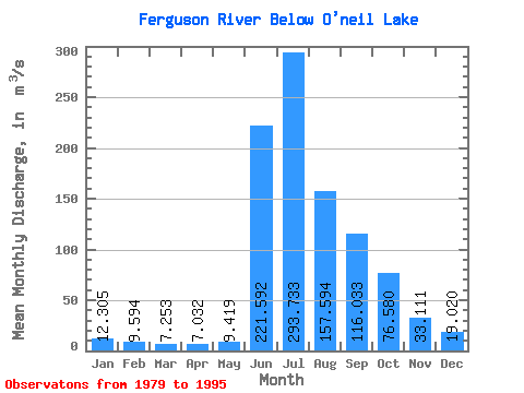
| Statistic | Jan | Feb | Mar | Apr | May | Jun | Jul | Aug | Sep | Oct | Nov | Dec | Annual |
|---|---|---|---|---|---|---|---|---|---|---|---|---|---|
| Mean | 12.30 | 9.59 | 7.25 | 7.03 | 9.42 | 221.59 | 293.73 | 157.59 | 116.03 | 76.58 | 33.11 | 19.02 | 80.95 |
| Standard Deviation | 8.81 | 6.86 | 6.49 | 6.92 | 9.84 | 100.10 | 104.30 | 28.89 | 26.43 | 25.22 | 14.76 | 10.68 | 17.48 |
| Min | 0.00 | 0.00 | 0.00 | 0.00 | 0.00 | 88.70 | 163.00 | 90.50 | 85.00 | 49.10 | 8.45 | 1.85 | 57.33 |
| Max | 29.00 | 20.40 | 17.60 | 17.50 | 26.60 | 491.00 | 563.00 | 225.00 | 180.00 | 136.00 | 70.50 | 45.50 | 113.50 |
| Coefficient of Variation | 0.72 | 0.71 | 0.90 | 0.98 | 1.04 | 0.45 | 0.35 | 0.18 | 0.23 | 0.33 | 0.45 | 0.56 | 0.22 |
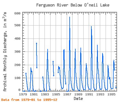
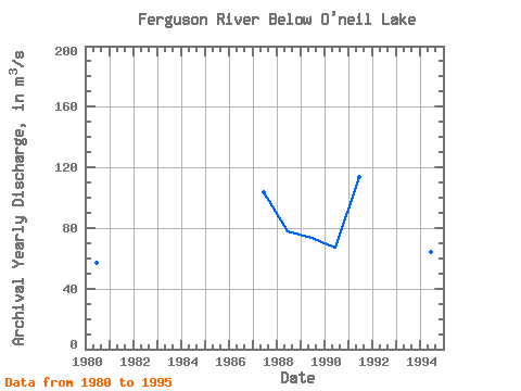
| Year | Jan | Feb | Mar | Apr | May | Jun | Jul | Aug | Sep | Oct | Nov | Dec | Annual | 1979 | 0.00 | 0.00 | 0.00 | 0.00 | 0.00 | 134.00 | 97.40 | 66.30 | 39.20 | 14.60 | 1980 | 0.16 | 0.00 | 0.00 | 0.00 | 0.00 | 88.70 | 177.00 | 148.00 | 151.00 | 98.60 | 20.60 | 3.88 | 57.33 | 1981 | 0.00 | 0.00 | 0.00 | 362.00 | 177.00 | 1982 | 0.00 | 0.00 | 0.00 | 107.00 | 70.10 | 8.45 | 1.85 | 1983 | 1.00 | 1.10 | 216.00 | 318.00 | 161.00 | 107.00 | 82.00 | 20.70 | 9.65 | 1984 | 224.00 | 118.00 | 1985 | 141.00 | 188.00 | 171.00 | 180.00 | 136.00 | 70.50 | 45.50 | 1986 | 29.00 | 20.40 | 16.40 | 17.40 | 26.60 | 311.00 | 316.00 | 157.00 | 108.00 | 54.30 | 1987 | 0.00 | 0.00 | 0.00 | 0.00 | 0.00 | 208.00 | 563.00 | 225.00 | 122.00 | 63.30 | 36.00 | 23.30 | 103.38 | 1988 | 15.80 | 11.40 | 8.15 | 6.23 | 6.02 | 226.00 | 319.00 | 152.00 | 90.40 | 49.10 | 27.10 | 20.30 | 77.62 | 1989 | 11.10 | 7.64 | 4.61 | 2.97 | 2.96 | 189.00 | 327.00 | 155.00 | 85.00 | 49.60 | 29.30 | 19.80 | 73.67 | 1990 | 13.40 | 10.70 | 9.37 | 9.30 | 10.70 | 142.00 | 209.00 | 164.00 | 129.00 | 59.40 | 29.60 | 21.90 | 67.36 | 1991 | 17.20 | 14.40 | 13.90 | 13.50 | 13.30 | 491.00 | 397.00 | 171.00 | 103.00 | 77.00 | 31.50 | 19.20 | 113.50 | 1992 | 11.40 | 8.59 | 9.40 | 12.80 | 17.70 | 169.00 | 349.00 | 178.00 | 149.00 | 108.00 | 51.50 | 27.40 | 90.98 | 1993 | 17.00 | 13.30 | 12.50 | 15.20 | 23.20 | 288.00 | 259.00 | 159.00 | 100.00 | 53.80 | 31.40 | 18.40 | 82.57 | 1994 | 12.40 | 10.30 | 9.61 | 9.58 | 20.90 | 196.00 | 163.00 | 90.50 | 92.70 | 104.00 | 39.40 | 25.10 | 64.46 | 1995 | 20.20 | 18.40 | 17.60 | 17.50 | 18.80 | 215.00 | 235.00 | 161.00 | 119.00 | 77.20 | 28.30 | 15.40 | 78.62 |
|---|
 Return to R-Arctic Net Home Page