|
|
|||||||||||||||||
| Point ID: 3131 | Downloads | Plots | Site Data | Code: 06FD001 |
|
|
|||||||||||||||||
| Download | |
|---|---|
| Site Descriptor Information | Site Time Series Data |
| Link to all available data | |
|
|
| View: | Statistics | Time Series |
| Units: | mm |
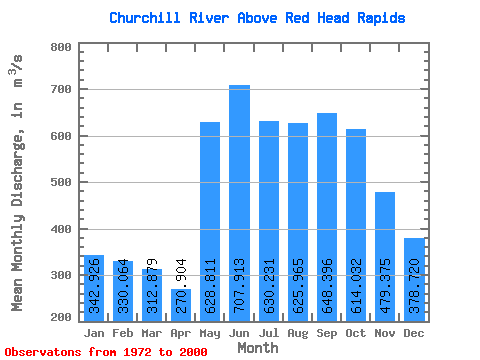
| Statistic | Jan | Feb | Mar | Apr | May | Jun | Jul | Aug | Sep | Oct | Nov | Dec | Annual |
|---|---|---|---|---|---|---|---|---|---|---|---|---|---|
| Mean | 342.93 | 330.06 | 312.88 | 270.90 | 628.81 | 707.91 | 630.23 | 625.97 | 648.40 | 614.03 | 479.38 | 378.72 | 563.41 |
| Standard Deviation | 393.11 | 388.17 | 366.30 | 336.34 | 469.32 | 454.06 | 553.51 | 556.94 | 603.79 | 538.35 | 411.44 | 374.38 | 447.51 |
| Min | 116.00 | 84.90 | 73.90 | 70.40 | 83.40 | 202.00 | 132.00 | 86.20 | 64.60 | 76.20 | 150.00 | 132.00 | 183.95 |
| Max | 1480.00 | 1300.00 | 1140.00 | 1110.00 | 1570.00 | 1860.00 | 1840.00 | 1760.00 | 1750.00 | 1610.00 | 1540.00 | 1420.00 | 1399.17 |
| Coefficient of Variation | 1.15 | 1.18 | 1.17 | 1.24 | 0.75 | 0.64 | 0.88 | 0.89 | 0.93 | 0.88 | 0.86 | 0.99 | 0.79 |
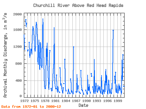
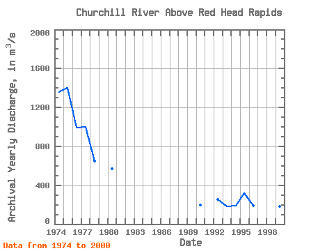
| Year | Jan | Feb | Mar | Apr | May | Jun | Jul | Aug | Sep | Oct | Nov | Dec | Annual | 1972 | 1480.00 | 1300.00 | 1140.00 | 1840.00 | 1670.00 | 1750.00 | 1973 | 1100.00 | 1120.00 | 1300.00 | 1030.00 | 942.00 | 1010.00 | 1030.00 | 1130.00 | 1974 | 1150.00 | 1130.00 | 1070.00 | 1020.00 | 1120.00 | 1420.00 | 1520.00 | 1680.00 | 1650.00 | 1610.00 | 1540.00 | 1420.00 | 1360.83 | 1975 | 1270.00 | 1150.00 | 1090.00 | 1090.00 | 1240.00 | 1640.00 | 1780.00 | 1760.00 | 1690.00 | 1590.00 | 1390.00 | 1100.00 | 1399.17 | 1976 | 885.00 | 791.00 | 775.00 | 1110.00 | 1360.00 | 1230.00 | 672.00 | 657.00 | 832.00 | 1300.00 | 1250.00 | 1080.00 | 995.17 | 1977 | 750.00 | 717.00 | 702.00 | 789.00 | 1570.00 | 1860.00 | 1690.00 | 1250.00 | 1050.00 | 838.00 | 499.00 | 277.00 | 999.33 | 1978 | 208.00 | 206.00 | 203.00 | 206.00 | 354.00 | 1150.00 | 780.00 | 1140.00 | 1290.00 | 1000.00 | 747.00 | 512.00 | 649.67 | 1979 | 400.00 | 309.00 | 237.00 | 186.00 | 430.00 | 1030.00 | 1110.00 | 212.00 | 163.00 | 1980 | 149.00 | 152.00 | 158.00 | 274.00 | 491.00 | 620.00 | 733.00 | 821.00 | 1650.00 | 888.00 | 582.00 | 345.00 | 571.92 | 1981 | 288.00 | 226.00 | 212.00 | 204.00 | 525.00 | 235.00 | 151.00 | 117.00 | 260.00 | 204.00 | 151.00 | 1982 | 137.00 | 130.00 | 124.00 | 119.00 | 701.00 | 655.00 | 285.00 | 309.00 | 328.00 | 277.00 | 220.00 | 1983 | 178.00 | 134.00 | 105.00 | 99.70 | 229.00 | 327.00 | 903.00 | 463.00 | 265.00 | 1984 | 201.00 | 177.00 | 157.00 | 91.90 | 151.00 | 197.00 | 157.00 | 1985 | 134.00 | 105.00 | 96.80 | 86.30 | 436.00 | 355.00 | 349.00 | 107.00 | 160.00 | 150.00 | 132.00 | 1986 | 122.00 | 89.60 | 77.70 | 86.70 | 1190.00 | 1987 | 130.00 | 113.00 | 110.00 | 124.00 | 543.00 | 376.00 | 243.00 | 125.00 | 271.00 | 1988 | 127.00 | 117.00 | 96.00 | 97.80 | 633.00 | 288.00 | 279.00 | 182.00 | 161.00 | 1989 | 150.00 | 110.00 | 106.00 | 78.10 | 168.00 | 143.00 | 1990 | 128.00 | 110.00 | 87.10 | 70.40 | 83.40 | 525.00 | 313.00 | 182.00 | 160.00 | 163.00 | 303.00 | 207.00 | 194.32 | 1991 | 147.00 | 137.00 | 101.00 | 565.00 | 501.00 | 247.00 | 198.00 | 1992 | 151.00 | 140.00 | 116.00 | 86.50 | 898.00 | 367.00 | 154.00 | 86.20 | 179.00 | 341.00 | 322.00 | 224.00 | 255.39 | 1993 | 160.00 | 130.00 | 117.00 | 115.00 | 288.00 | 202.00 | 202.00 | 158.00 | 154.00 | 234.00 | 263.00 | 204.00 | 185.58 | 1994 | 156.00 | 125.00 | 105.00 | 89.00 | 429.00 | 520.00 | 245.00 | 103.00 | 64.60 | 76.20 | 180.00 | 169.00 | 188.48 | 1995 | 155.00 | 138.00 | 114.00 | 89.20 | 267.00 | 376.00 | 132.00 | 568.00 | 665.00 | 293.00 | 524.00 | 475.00 | 316.35 | 1996 | 229.00 | 114.00 | 82.90 | 76.00 | 222.00 | 413.00 | 369.00 | 232.00 | 112.00 | 89.50 | 196.00 | 183.00 | 193.20 | 1997 | 135.00 | 108.00 | 101.00 | 79.90 | 107.00 | 332.00 | 195.00 | 478.00 | 1160.00 | 1590.00 | 1998 | 498.00 | 341.00 | 589.00 | 194.00 | 143.00 | 113.00 | 109.00 | 298.00 | 223.00 | 1999 | 116.00 | 98.30 | 98.10 | 116.00 | 239.00 | 320.00 | 151.00 | 240.00 | 278.00 | 192.00 | 202.00 | 157.00 | 183.95 | 2000 | 123.00 | 84.90 | 73.90 | 139.00 | 887.00 | 452.00 | 402.00 | 1010.00 | 744.00 | 383.00 | 261.00 | 172.00 | 394.32 |
|---|
 Return to R-Arctic Net Home Page