|
|
|||||||||||||||||
| Point ID: 3108 | Downloads | Plots | Site Data | Code: 05UB011 |
|
|
|||||||||||||||||
| Download | |
|---|---|
| Site Descriptor Information | Site Time Series Data |
| Link to all available data | |
|
|
| View: | Statistics | Time Series |
| Units: | mm |
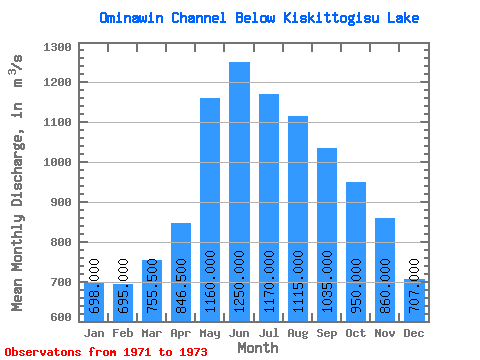
| Statistic | Jan | Feb | Mar | Apr | May | Jun | Jul | Aug | Sep | Oct | Nov | Dec | Annual |
|---|---|---|---|---|---|---|---|---|---|---|---|---|---|
| Mean | 698.00 | 695.00 | 755.50 | 846.50 | 1160.00 | 1250.00 | 1170.00 | 1115.00 | 1035.00 | 950.00 | 860.00 | 707.00 | 959.75 |
| Standard Deviation | 93.34 | 99.00 | 99.70 | 111.02 | 14.14 | 7.07 | 21.21 | ||||||
| Min | 632.00 | 625.00 | 685.00 | 768.00 | 1160.00 | 1250.00 | 1160.00 | 1110.00 | 1020.00 | 950.00 | 860.00 | 707.00 | 959.75 |
| Max | 764.00 | 765.00 | 826.00 | 925.00 | 1160.00 | 1250.00 | 1180.00 | 1120.00 | 1050.00 | 950.00 | 860.00 | 707.00 | 959.75 |
| Coefficient of Variation | 0.13 | 0.14 | 0.13 | 0.13 | 0.01 | 0.01 | 0.02 |
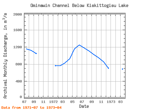
| Year | Jan | Feb | Mar | Apr | May | Jun | Jul | Aug | Sep | Oct | Nov | Dec | Annual | 1971 | 1160.00 | 1120.00 | 1050.00 | 1972 | 764.00 | 765.00 | 826.00 | 925.00 | 1160.00 | 1250.00 | 1180.00 | 1110.00 | 1020.00 | 950.00 | 860.00 | 707.00 | 959.75 | 1973 | 632.00 | 625.00 | 685.00 | 768.00 |
|---|
 Return to R-Arctic Net Home Page