|
|
|||||||||||||||||
| Point ID: 3105 | Downloads | Plots | Site Data | Code: 05UB008 |
|
|
|||||||||||||||||
| Download | |
|---|---|
| Site Descriptor Information | Site Time Series Data |
| Link to all available data | |
|
|
| View: | Statistics | Time Series |
| Units: | mm |
| Statistic | Jan | Feb | Mar | Apr | May | Jun | Jul | Aug | Sep | Oct | Nov | Dec | Annual |
|---|---|---|---|---|---|---|---|---|---|---|---|---|---|
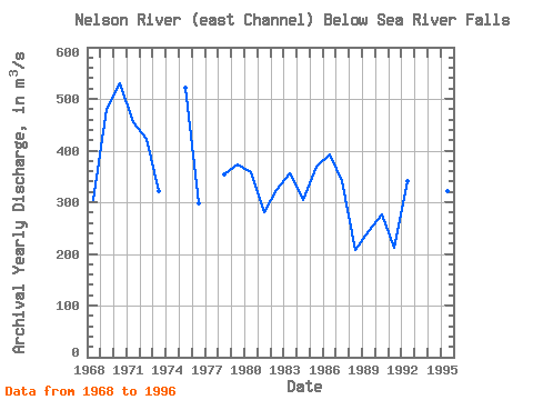
| Mean | 207.56 | 206.59 | 215.61 | 292.57 | 441.20 | 498.48 | 507.52 | 497.59 | 446.52 | 376.90 | 284.50 | 214.58 | 349.37 |
| Standard Deviation | 85.31 | 84.97 | 83.05 | 115.89 | 136.93 | 130.52 | 132.26 | 122.44 | 114.62 | 100.85 | 108.33 | 81.56 | 80.58 |
| Min | 84.10 | 83.80 | 84.40 | 115.00 | 183.00 | 334.00 | 180.00 | 178.00 | 185.00 | 192.00 | 92.40 | 86.70 | 208.42 |
| Max | 398.00 | 401.00 | 393.00 | 496.00 | 699.00 | 879.00 | 883.00 | 814.00 | 708.00 | 580.00 | 521.00 | 412.00 | 529.92 |
| Coefficient of Variation | 0.41 | 0.41 | 0.39 | 0.40 | 0.31 | 0.26 | 0.26 | 0.25 | 0.26 | 0.27 | 0.38 | 0.38 | 0.23 |
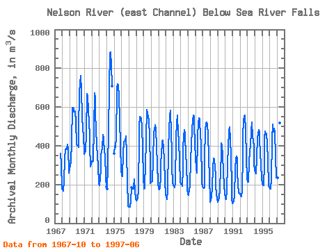
| Year | Jan | Feb | Mar | Apr | May | Jun | Jul | Aug | Sep | Oct | Nov | Dec | Annual | 1967 | 361.00 | 307.00 | 177.00 | 1968 | 174.00 | 175.00 | 165.00 | 220.00 | 330.00 | 380.00 | 385.00 | 383.00 | 406.00 | 383.00 | 394.00 | 260.00 | 304.58 | 1969 | 281.00 | 300.00 | 312.00 | 422.00 | 596.00 | 597.00 | 592.00 | 577.00 | 575.00 | 580.00 | 521.00 | 412.00 | 480.42 | 1970 | 398.00 | 398.00 | 393.00 | 481.00 | 675.00 | 720.00 | 761.00 | 682.00 | 554.00 | 483.00 | 457.00 | 357.00 | 529.92 | 1971 | 365.00 | 372.00 | 371.00 | 469.00 | 668.00 | 659.00 | 578.00 | 525.00 | 448.00 | 400.00 | 293.00 | 305.00 | 454.42 | 1972 | 319.00 | 316.00 | 320.00 | 496.00 | 673.00 | 648.00 | 563.00 | 487.00 | 402.00 | 348.00 | 297.00 | 202.00 | 422.58 | 1973 | 197.00 | 232.00 | 275.00 | 355.00 | 367.00 | 388.00 | 456.00 | 436.00 | 366.00 | 356.00 | 231.00 | 187.00 | 320.50 | 1974 | 177.00 | 294.00 | 474.00 | 699.00 | 879.00 | 883.00 | 814.00 | 708.00 | 1975 | 362.00 | 401.00 | 392.00 | 445.00 | 675.00 | 702.00 | 718.00 | 711.00 | 654.00 | 531.00 | 404.00 | 274.00 | 522.42 | 1976 | 246.00 | 241.00 | 250.00 | 362.00 | 420.00 | 426.00 | 424.00 | 451.00 | 358.00 | 218.00 | 92.40 | 86.70 | 297.93 | 1977 | 84.10 | 83.80 | 84.40 | 115.00 | 183.00 | 180.00 | 178.00 | 185.00 | 226.00 | 165.00 | 125.00 | 1978 | 118.00 | 121.00 | 129.00 | 171.00 | 449.00 | 503.00 | 551.00 | 546.00 | 541.00 | 495.00 | 387.00 | 236.00 | 353.92 | 1979 | 177.00 | 182.00 | 222.00 | 282.00 | 440.00 | 587.00 | 569.00 | 549.00 | 532.00 | 447.00 | 292.00 | 207.00 | 373.83 | 1980 | 213.00 | 214.00 | 216.00 | 324.00 | 472.00 | 477.00 | 508.00 | 488.00 | 478.00 | 400.00 | 304.00 | 208.00 | 358.50 | 1981 | 176.00 | 173.00 | 186.00 | 240.00 | 315.00 | 349.00 | 424.00 | 430.00 | 386.00 | 330.00 | 211.00 | 151.00 | 280.92 | 1982 | 133.00 | 126.00 | 123.00 | 171.00 | 385.00 | 483.00 | 552.00 | 583.00 | 463.00 | 375.00 | 289.00 | 212.00 | 324.58 | 1983 | 197.00 | 191.00 | 185.00 | 208.00 | 441.00 | 514.00 | 558.00 | 547.00 | 473.00 | 420.00 | 323.00 | 210.00 | 355.58 | 1984 | 204.00 | 199.00 | 193.00 | 280.00 | 393.00 | 447.00 | 482.00 | 462.00 | 342.00 | 313.00 | 181.00 | 147.00 | 303.58 | 1985 | 145.00 | 153.00 | 167.00 | 194.00 | 329.00 | 398.00 | 490.00 | 529.00 | 557.00 | 554.00 | 502.00 | 409.00 | 368.92 | 1986 | 338.00 | 284.00 | 259.00 | 434.00 | 530.00 | 513.00 | 543.00 | 535.00 | 443.00 | 420.00 | 212.00 | 189.00 | 391.67 | 1987 | 185.00 | 180.00 | 186.00 | 341.00 | 476.00 | 519.00 | 521.00 | 506.00 | 461.00 | 343.00 | 229.00 | 132.00 | 339.92 | 1988 | 110.00 | 115.00 | 140.00 | 182.00 | 287.00 | 334.00 | 329.00 | 284.00 | 251.00 | 192.00 | 150.00 | 127.00 | 208.42 | 1989 | 110.00 | 115.00 | 133.00 | 174.00 | 283.00 | 345.00 | 414.00 | 399.00 | 349.00 | 265.00 | 195.00 | 155.00 | 244.75 | 1990 | 129.00 | 123.00 | 130.00 | 163.00 | 306.00 | 392.00 | 475.00 | 495.00 | 433.00 | 350.00 | 187.00 | 123.00 | 275.50 | 1991 | 103.00 | 106.00 | 118.00 | 137.00 | 283.00 | 336.00 | 347.00 | 332.00 | 259.00 | 202.00 | 157.00 | 155.00 | 211.25 | 1992 | 148.00 | 143.00 | 139.00 | 166.00 | 353.00 | 452.00 | 530.00 | 555.00 | 556.00 | 482.00 | 343.00 | 231.00 | 341.50 | 1993 | 215.00 | 214.00 | 216.00 | 310.00 | 378.00 | 396.00 | 476.00 | 522.00 | 444.00 | 433.00 | 390.00 | 299.00 | 357.75 | 1994 | 276.00 | 260.00 | 258.00 | 336.00 | 444.00 | 461.00 | 482.00 | 472.00 | 443.00 | 352.00 | 309.00 | 229.00 | 360.17 | 1995 | 206.00 | 194.00 | 195.00 | 307.00 | 438.00 | 474.00 | 456.00 | 463.00 | 412.00 | 325.00 | 195.00 | 184.00 | 320.75 | 1996 | 177.00 | 176.00 | 183.00 | 225.00 | 431.00 | 510.00 | 471.00 | 489.00 | 470.00 | 346.00 | 233.00 | 233.00 | 328.67 | 1997 | 233.00 | 233.00 | 234.00 | 293.00 | 517.00 | 567.00 |
|---|
 Return to R-Arctic Net Home Page
