|
|
|||||||||||||||||
| Point ID: 30 | Downloads | Plots | Site Data | Code: 05AB007 |
|
|
|||||||||||||||||
| Download | |
|---|---|
| Site Descriptor Information | Site Time Series Data |
| Link to all available data | |
|
|
| View: | Statistics | Time Series |
| Units: | mm |
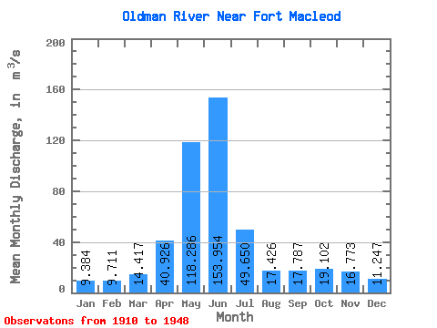
| Statistic | Jan | Feb | Mar | Apr | May | Jun | Jul | Aug | Sep | Oct | Nov | Dec | Annual |
|---|---|---|---|---|---|---|---|---|---|---|---|---|---|
| Mean | 9.38 | 9.71 | 14.42 | 40.93 | 118.29 | 153.95 | 49.65 | 17.43 | 17.79 | 19.10 | 16.77 | 11.25 | 38.28 |
| Standard Deviation | 4.00 | 6.53 | 8.57 | 24.67 | 52.17 | 92.14 | 35.66 | 15.80 | 22.72 | 15.79 | 9.17 | 4.94 | 15.69 |
| Min | 4.30 | 3.98 | 5.69 | 3.40 | 15.30 | 29.80 | 2.51 | 0.78 | 0.79 | 2.04 | 6.71 | 5.10 | 8.09 |
| Max | 24.20 | 37.20 | 38.30 | 115.00 | 244.00 | 446.00 | 143.00 | 58.90 | 115.00 | 59.30 | 38.90 | 26.10 | 74.90 |
| Coefficient of Variation | 0.43 | 0.67 | 0.59 | 0.60 | 0.44 | 0.60 | 0.72 | 0.91 | 1.28 | 0.83 | 0.55 | 0.44 | 0.41 |
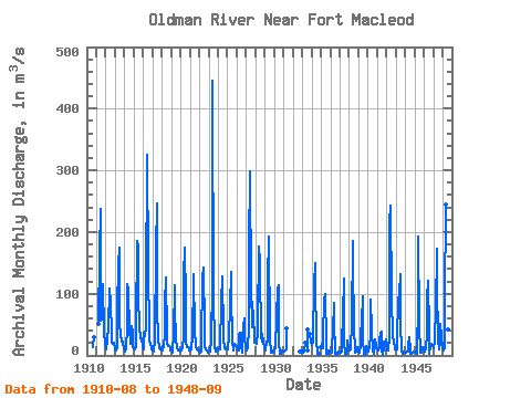
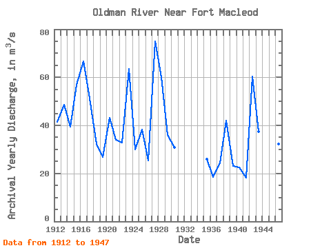
| Year | Jan | Feb | Mar | Apr | May | Jun | Jul | Aug | Sep | Oct | Nov | Dec | Annual | 1910 | 13.00 | 17.70 | 29.90 | 1911 | 50.40 | 168.00 | 237.00 | 55.90 | 58.90 | 115.00 | 36.50 | 38.90 | 18.20 | 1912 | 11.20 | 10.70 | 24.00 | 46.30 | 106.00 | 108.00 | 84.90 | 34.40 | 20.70 | 19.70 | 20.20 | 12.00 | 41.51 | 1913 | 8.66 | 8.03 | 10.90 | 73.90 | 148.00 | 174.00 | 51.30 | 32.80 | 21.60 | 21.90 | 18.90 | 11.70 | 48.47 | 1914 | 8.01 | 6.65 | 11.40 | 44.60 | 116.00 | 104.00 | 42.80 | 21.70 | 19.10 | 47.30 | 36.20 | 14.30 | 39.34 | 1915 | 12.10 | 9.67 | 13.30 | 48.50 | 185.00 | 174.00 | 93.60 | 46.60 | 26.90 | 31.80 | 25.20 | 15.50 | 56.85 | 1916 | 9.60 | 37.20 | 30.60 | 45.20 | 103.00 | 326.00 | 143.00 | 35.90 | 25.80 | 17.80 | 15.90 | 9.20 | 66.60 | 1917 | 7.78 | 7.06 | 7.64 | 24.20 | 172.00 | 247.00 | 79.60 | 24.70 | 15.10 | 11.20 | 9.60 | 7.28 | 51.10 | 1918 | 14.60 | 8.00 | 16.10 | 33.10 | 86.00 | 126.00 | 32.50 | 18.90 | 15.60 | 14.90 | 11.30 | 8.80 | 32.15 | 1919 | 8.55 | 5.08 | 8.55 | 35.40 | 114.00 | 75.60 | 25.30 | 13.10 | 8.46 | 9.84 | 9.06 | 7.12 | 26.67 | 1920 | 6.09 | 7.29 | 12.60 | 29.50 | 129.00 | 175.00 | 91.10 | 22.90 | 13.10 | 14.00 | 10.40 | 7.44 | 43.20 | 1921 | 8.09 | 9.22 | 10.60 | 32.70 | 121.00 | 132.00 | 39.60 | 14.90 | 10.50 | 12.10 | 8.22 | 7.86 | 33.90 | 1922 | 6.79 | 5.34 | 5.99 | 18.80 | 127.00 | 143.00 | 42.30 | 15.70 | 8.97 | 8.41 | 8.22 | 5.10 | 32.97 | 1923 | 6.46 | 5.87 | 7.69 | 23.10 | 118.00 | 446.00 | 79.60 | 32.40 | 16.00 | 6.49 | 11.20 | 8.10 | 63.41 | 1924 | 7.34 | 10.60 | 9.37 | 15.10 | 84.60 | 128.00 | 35.90 | 25.90 | 12.20 | 10.50 | 10.40 | 10.30 | 30.02 | 1925 | 11.30 | 10.20 | 31.30 | 78.10 | 136.00 | 101.00 | 22.90 | 8.28 | 12.30 | 19.20 | 14.90 | 15.30 | 38.40 | 1926 | 9.92 | 9.10 | 8.14 | 33.40 | 37.60 | 37.30 | 16.50 | 4.71 | 47.30 | 59.30 | 25.30 | 15.60 | 25.35 | 1927 | 9.63 | 8.29 | 11.00 | 44.70 | 173.00 | 299.00 | 109.00 | 46.30 | 86.40 | 59.20 | 31.60 | 20.70 | 74.90 | 1928 | 24.20 | 18.20 | 38.30 | 50.80 | 177.00 | 151.00 | 140.00 | 32.10 | 23.10 | 34.30 | 20.00 | 13.20 | 60.18 | 1929 | 8.25 | 7.47 | 21.90 | 22.50 | 122.00 | 193.00 | 27.50 | 5.36 | 3.85 | 3.97 | 8.16 | 7.11 | 35.92 | 1930 | 6.24 | 14.20 | 13.20 | 61.80 | 109.00 | 114.00 | 22.20 | 3.15 | 3.50 | 7.70 | 8.34 | 6.21 | 30.80 | 1931 | 6.88 | 5.81 | 7.25 | 10.20 | 43.70 | 1932 | 5.51 | 6.81 | 1933 | 6.79 | 4.47 | 6.82 | 21.20 | 42.10 | 8.85 | 34.50 | 21.00 | 1934 | 17.00 | 20.60 | 28.10 | 115.00 | 150.00 | 118.00 | 26.70 | 2.48 | 2.87 | 13.20 | 1935 | 14.30 | 19.10 | 12.10 | 30.60 | 88.80 | 99.90 | 23.00 | 2.62 | 1.91 | 3.23 | 8.35 | 6.42 | 25.86 | 1936 | 5.48 | 3.98 | 12.30 | 39.50 | 84.40 | 57.60 | 2.51 | 0.78 | 0.79 | 2.04 | 6.92 | 5.51 | 18.48 | 1937 | 4.30 | 4.67 | 6.73 | 18.30 | 65.10 | 125.00 | 23.20 | 1.80 | 1.10 | 7.44 | 24.10 | 10.60 | 24.36 | 1938 | 8.00 | 7.72 | 10.30 | 54.30 | 185.00 | 154.00 | 42.50 | 9.56 | 4.39 | 6.38 | 13.50 | 8.42 | 42.01 | 1939 | 6.95 | 5.31 | 14.70 | 32.90 | 54.20 | 95.60 | 26.00 | 1.51 | 1.44 | 10.10 | 14.70 | 11.90 | 22.94 | 1940 | 7.03 | 6.64 | 15.60 | 29.70 | 89.80 | 40.70 | 8.08 | 2.90 | 15.80 | 25.70 | 17.70 | 12.10 | 22.65 | 1941 | 9.22 | 7.61 | 11.20 | 26.40 | 34.30 | 38.90 | 10.20 | 1.70 | 13.20 | 23.20 | 16.60 | 26.10 | 18.22 | 1942 | 16.70 | 8.35 | 8.10 | 30.90 | 215.00 | 243.00 | 92.00 | 33.80 | 32.30 | 19.90 | 14.60 | 10.50 | 60.43 | 1943 | 8.16 | 9.84 | 28.30 | 89.30 | 102.00 | 132.00 | 53.50 | 6.00 | 4.08 | 3.43 | 6.99 | 5.15 | 37.40 | 1944 | 5.16 | 5.29 | 5.69 | 5.55 | 15.30 | 29.80 | 9.32 | 2.13 | 2.07 | 3.93 | 6.71 | 6.17 | 8.09 | 1945 | 5.68 | 5.03 | 6.95 | 3.40 | 86.90 | 192.00 | 49.40 | 3.87 | 3.89 | 10.10 | 13.40 | 9.35 | 32.50 | 1946 | 8.07 | 6.67 | 10.30 | 35.40 | 94.60 | 121.00 | 38.10 | 3.25 | 15.20 | 19.60 | 19.40 | 14.70 | 32.19 | 1947 | 12.40 | 22.00 | 29.00 | 73.20 | 173.00 | 117.00 | 26.70 | 10.20 | 22.60 | 50.70 | 30.80 | 11.50 | 48.26 | 1948 | 10.90 | 8.34 | 13.00 | 86.30 | 244.00 | 333.00 | 78.60 | 41.60 | 7.79 |
|---|
 Return to R-Arctic Net Home Page