|
|
|||||||||||||||||
| Point ID: 2979 | Downloads | Plots | Site Data | Code: 05OB033 |
|
|
|||||||||||||||||
| Download | |
|---|---|
| Site Descriptor Information | Site Time Series Data |
| Link to all available data | |
|
|
| View: | Statistics | Time Series |
| Units: | mm |
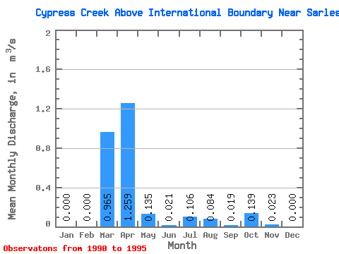
| Statistic | Jan | Feb | Mar | Apr | May | Jun | Jul | Aug | Sep | Oct | Nov | Dec | Annual |
|---|---|---|---|---|---|---|---|---|---|---|---|---|---|
| Mean | 0.00 | 0.00 | 0.96 | 1.26 | 0.14 | 0.02 | 0.11 | 0.08 | 0.02 | 0.14 | 0.02 | 0.00 | 0.16 |
| Standard Deviation | 0.00 | 0.00 | 0.99 | 1.60 | 0.23 | 0.03 | 0.26 | 0.20 | 0.04 | 0.30 | 0.05 | 0.00 | 0.12 |
| Min | 0.00 | 0.00 | 0.00 | 0.07 | 0.01 | 0.00 | 0.00 | 0.00 | 0.00 | 0.00 | 0.00 | 0.00 | 0.04 |
| Max | 0.00 | 0.00 | 2.37 | 4.40 | 0.60 | 0.06 | 0.63 | 0.50 | 0.10 | 0.69 | 0.11 | 0.00 | 0.32 |
| Coefficient of Variation | 1.03 | 1.27 | 1.70 | 1.19 | 2.40 | 2.45 | 2.00 | 2.20 | 2.19 | 2.24 | 0.75 |
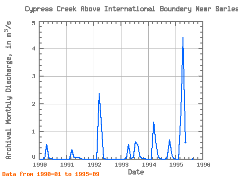
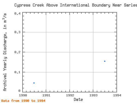
| Year | Jan | Feb | Mar | Apr | May | Jun | Jul | Aug | Sep | Oct | Nov | Dec | Annual | 1990 | 0.00 | 0.00 | 0.00 | 0.53 | 0.01 | 0.00 | 0.00 | 0.00 | 0.00 | 0.00 | 0.00 | 0.00 | 0.04 | 1991 | 0.00 | 0.00 | 0.33 | 0.07 | 0.07 | 0.06 | 0.01 | 0.00 | 0.00 | 0.00 | 0.00 | 0.00 | 0.04 | 1992 | 0.00 | 0.00 | 2.37 | 1.39 | 0.03 | 0.00 | 0.00 | 0.00 | 0.00 | 0.00 | 0.00 | 0.00 | 0.32 | 1993 | 0.00 | 0.00 | 0.02 | 0.53 | 0.03 | 0.04 | 0.63 | 0.50 | 0.10 | 0.01 | 0.00 | 0.00 | 0.15 | 1994 | 0.00 | 0.00 | 1.34 | 0.63 | 0.08 | 0.00 | 0.00 | 0.00 | 0.02 | 0.69 | 0.11 | 0.00 | 0.24 | 1995 | 0.00 | 0.00 | 1.73 | 4.40 | 0.60 | 0.02 | 0.00 | 0.00 | 0.00 |
|---|
 Return to R-Arctic Net Home Page