|
|
|||||||||||||||||
| Point ID: 2921 | Downloads | Plots | Site Data | Code: 05MJ005 |
|
|
|||||||||||||||||
| Download | |
|---|---|
| Site Descriptor Information | Site Time Series Data |
| Link to all available data | |
|
|
| View: | Statistics | Time Series |
| Units: | mm |
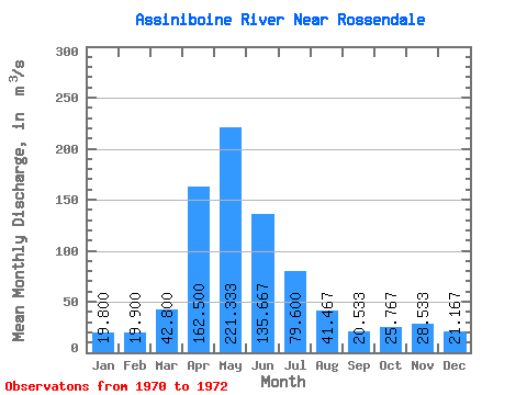
| Statistic | Jan | Feb | Mar | Apr | May | Jun | Jul | Aug | Sep | Oct | Nov | Dec | Annual |
|---|---|---|---|---|---|---|---|---|---|---|---|---|---|
| Mean | 19.80 | 19.90 | 42.80 | 162.50 | 221.33 | 135.67 | 79.60 | 41.47 | 20.53 | 25.77 | 28.53 | 21.17 | 60.34 |
| Standard Deviation | 6.65 | 7.50 | 30.83 | 51.62 | 90.47 | 41.43 | 38.81 | 18.01 | 3.56 | 2.67 | 4.31 | 5.16 | 9.29 |
| Min | 15.10 | 14.60 | 21.00 | 126.00 | 126.00 | 106.00 | 42.60 | 22.70 | 18.00 | 22.70 | 24.90 | 16.90 | 53.77 |
| Max | 24.50 | 25.20 | 64.60 | 199.00 | 306.00 | 183.00 | 120.00 | 58.60 | 24.60 | 27.60 | 33.30 | 26.90 | 66.91 |
| Coefficient of Variation | 0.34 | 0.38 | 0.72 | 0.32 | 0.41 | 0.30 | 0.49 | 0.43 | 0.17 | 0.10 | 0.15 | 0.24 | 0.15 |
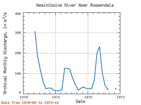
| Year | Jan | Feb | Mar | Apr | May | Jun | Jul | Aug | Sep | Oct | Nov | Dec | Annual | 1970 | 306.00 | 183.00 | 120.00 | 58.60 | 24.60 | 27.60 | 27.40 | 16.90 | 1971 | 15.10 | 14.60 | 21.00 | 126.00 | 126.00 | 118.00 | 76.20 | 43.10 | 18.00 | 27.00 | 33.30 | 26.90 | 53.77 | 1972 | 24.50 | 25.20 | 64.60 | 199.00 | 232.00 | 106.00 | 42.60 | 22.70 | 19.00 | 22.70 | 24.90 | 19.70 | 66.91 |
|---|
 Return to R-Arctic Net Home Page