|
|
|||||||||||||||||
| Point ID: 2880 | Downloads | Plots | Site Data | Code: 05ME002 |
|
|
|||||||||||||||||
| Download | |
|---|---|
| Site Descriptor Information | Site Time Series Data |
| Link to all available data | |
|
|
| View: | Statistics | Time Series |
| Units: | mm |
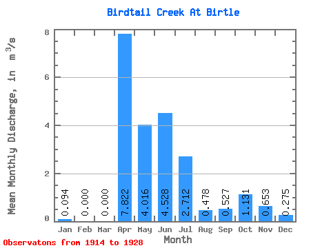
| Statistic | Jan | Feb | Mar | Apr | May | Jun | Jul | Aug | Sep | Oct | Nov | Dec | Annual |
|---|---|---|---|---|---|---|---|---|---|---|---|---|---|
| Mean | 0.09 | 0.00 | 0.00 | 7.82 | 4.02 | 4.53 | 2.71 | 0.48 | 0.53 | 1.13 | 0.65 | 0.28 | 1.52 |
| Standard Deviation | 0.16 | 0.00 | 0.00 | 6.87 | 2.20 | 3.75 | 2.51 | 0.54 | 0.32 | 0.85 | 0.54 | 0.23 | 0.92 |
| Min | 0.00 | 0.00 | 0.00 | 1.28 | 0.72 | 0.96 | 0.36 | 0.06 | 0.08 | 0.15 | 0.12 | 0.05 | 0.70 |
| Max | 0.28 | 0.00 | 0.00 | 19.30 | 6.48 | 8.78 | 6.34 | 1.41 | 0.97 | 2.34 | 1.28 | 0.57 | 2.51 |
| Coefficient of Variation | 1.73 | 0.88 | 0.55 | 0.83 | 0.92 | 1.13 | 0.61 | 0.75 | 0.83 | 0.83 | 0.61 |
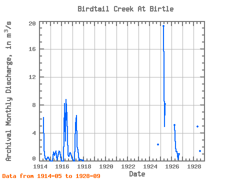
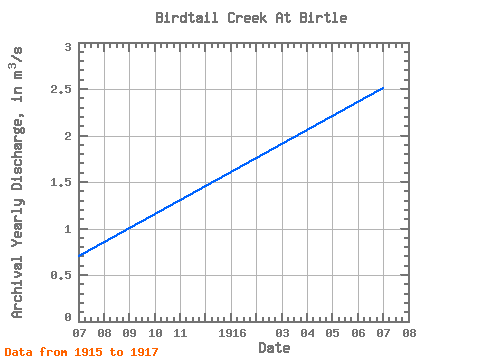
| Year | Jan | Feb | Mar | Apr | May | Jun | Jul | Aug | Sep | Oct | Nov | Dec | Annual | 1914 | 6.23 | 1.72 | 0.36 | 0.21 | 0.24 | 0.53 | 0.28 | 0.14 | 1915 | 0.00 | 0.00 | 0.00 | 1.28 | 0.72 | 0.96 | 1.37 | 0.14 | 0.69 | 1.42 | 1.28 | 0.57 | 0.70 | 1916 | 0.00 | 0.00 | 0.00 | 8.22 | 2.82 | 8.78 | 6.34 | 0.85 | 0.63 | 1.21 | 0.93 | 0.34 | 2.51 | 1917 | 0.28 | 0.00 | 0.00 | 5.21 | 6.48 | 2.12 | 1.44 | 0.06 | 0.08 | 0.15 | 0.12 | 0.05 | 1.33 | 1924 | 2.34 | 1925 | 19.30 | 4.92 | 8.15 | 1926 | 5.10 | 2.01 | 1.35 | 1.33 | 0.19 | 0.97 | 1928 | 4.93 | 8.62 | 5.43 | 1.41 | 0.56 |
|---|
 Return to R-Arctic Net Home Page