|
|
|||||||||||||||||
| Point ID: 2838 | Downloads | Plots | Site Data | Code: 05LJ030 |
|
|
|||||||||||||||||
| Download | |
|---|---|
| Site Descriptor Information | Site Time Series Data |
| Link to all available data | |
|
|
| View: | Statistics | Time Series |
| Units: | mm |
| Statistic | Jan | Feb | Mar | Apr | May | Jun | Jul | Aug | Sep | Oct | Nov | Dec | Annual |
|---|---|---|---|---|---|---|---|---|---|---|---|---|---|
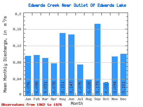
| Mean | 0.10 | 0.10 | 0.09 | 0.08 | 0.15 | 0.15 | 0.07 | 0.04 | 0.17 | 0.03 | 0.09 | 0.10 | 0.10 |
| Standard Deviation | 0.02 | 0.02 | 0.02 | 0.04 | 0.23 | 0.19 | 0.11 | 0.03 | 0.47 | 0.04 | 0.03 | 0.02 | 0.05 |
| Min | 0.07 | 0.07 | 0.06 | 0.00 | 0.01 | 0.01 | 0.01 | 0.00 | 0.00 | 0.00 | 0.04 | 0.07 | 0.05 |
| Max | 0.14 | 0.14 | 0.15 | 0.17 | 0.78 | 0.60 | 0.42 | 0.10 | 1.80 | 0.14 | 0.15 | 0.15 | 0.24 |
| Coefficient of Variation | 0.22 | 0.19 | 0.23 | 0.57 | 1.54 | 1.27 | 1.44 | 0.85 | 2.71 | 1.13 | 0.32 | 0.24 | 0.56 |
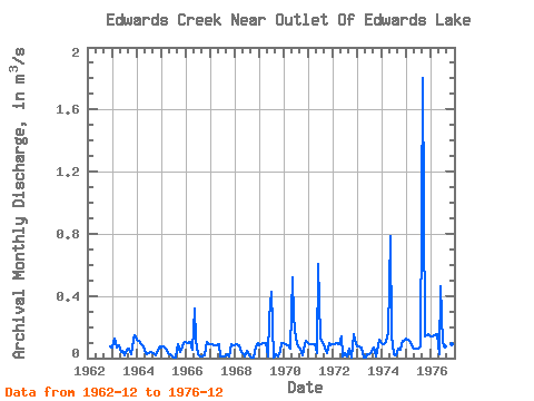
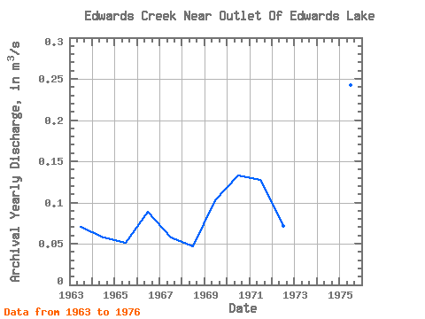
| Year | Jan | Feb | Mar | Apr | May | Jun | Jul | Aug | Sep | Oct | Nov | Dec | Annual | 1962 | 0.07 | 1963 | 0.07 | 0.12 | 0.07 | 0.08 | 0.04 | 0.04 | 0.01 | 0.06 | 0.06 | 0.03 | 0.12 | 0.14 | 0.07 | 1964 | 0.12 | 0.11 | 0.09 | 0.08 | 0.03 | 0.02 | 0.03 | 0.04 | 0.03 | 0.02 | 0.06 | 0.07 | 0.06 | 1965 | 0.07 | 0.07 | 0.06 | 0.03 | 0.03 | 0.02 | 0.01 | 0.00 | 0.09 | 0.04 | 0.07 | 0.11 | 0.05 | 1966 | 0.10 | 0.10 | 0.10 | 0.05 | 0.32 | 0.12 | 0.03 | 0.01 | 0.01 | 0.01 | 0.10 | 0.10 | 0.09 | 1967 | 0.09 | 0.09 | 0.09 | 0.09 | 0.09 | 0.01 | 0.01 | 0.01 | 0.03 | 0.01 | 0.09 | 0.08 | 0.06 | 1968 | 0.09 | 0.09 | 0.08 | 0.04 | 0.03 | 0.01 | 0.04 | 0.02 | 0.00 | 0.00 | 0.07 | 0.10 | 0.05 | 1969 | 0.08 | 0.09 | 0.10 | 0.09 | 0.01 | 0.26 | 0.42 | 0.00 | 0.03 | 0.01 | 0.04 | 0.09 | 0.10 | 1970 | 0.10 | 0.09 | 0.08 | 0.06 | 0.52 | 0.26 | 0.13 | 0.07 | 0.06 | 0.02 | 0.09 | 0.11 | 0.13 | 1971 | 0.10 | 0.09 | 0.09 | 0.09 | 0.03 | 0.60 | 0.13 | 0.10 | 0.07 | 0.03 | 0.10 | 0.09 | 0.13 | 1972 | 0.09 | 0.09 | 0.09 | 0.09 | 0.14 | 0.01 | 0.03 | 0.01 | 0.06 | 0.00 | 0.15 | 0.09 | 0.07 | 1973 | 0.08 | 0.07 | 0.07 | 0.00 | 0.01 | 0.02 | 0.03 | 0.04 | 0.07 | 0.01 | 0.08 | 0.12 | 0.05 | 1974 | 0.10 | 0.09 | 0.10 | 0.17 | 0.78 | 0.15 | 0.03 | 0.02 | 0.06 | 0.06 | 0.11 | 0.11 | 0.15 | 1975 | 0.12 | 0.12 | 0.10 | 0.07 | 0.06 | 0.06 | 0.06 | 0.08 | 1.80 | 0.14 | 0.15 | 0.15 | 0.24 | 1976 | 0.14 | 0.14 | 0.15 | 0.15 | 0.03 | 0.46 | 0.10 | 0.08 | 0.04 | 0.05 | 0.09 | 0.07 | 0.12 |
|---|
 Return to R-Arctic Net Home Page