|
|
|||||||||||||||||
| Point ID: 2791 | Downloads | Plots | Site Data | Code: 05KK007 |
|
|
|||||||||||||||||
| Download | |
|---|---|
| Site Descriptor Information | Site Time Series Data |
| Link to all available data | |
|
|
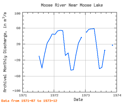
| View: | Statistics | Time Series |
| Units: | mm |
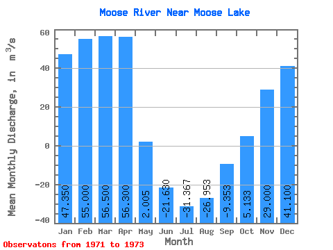
| Statistic | Jan | Feb | Mar | Apr | May | Jun | Jul | Aug | Sep | Oct | Nov | Dec | Annual |
|---|---|---|---|---|---|---|---|---|---|---|---|---|---|
| Mean | 47.35 | 55.00 | 56.50 | 56.30 | 2.00 | -21.63 | -31.37 | -26.95 | -9.35 | 5.13 | 29.00 | 41.10 | 14.26 |
| Standard Deviation | 4.03 | 3.25 | 2.55 | 3.82 | 14.70 | 27.96 | 18.69 | 26.93 | 4.94 | 30.08 | 10.24 | 5.37 | |
| Min | 44.50 | 52.70 | 54.70 | 53.60 | -8.39 | -41.40 | -45.20 | -44.70 | -15.00 | -29.60 | 17.40 | 37.30 | 14.26 |
| Max | 50.20 | 57.30 | 58.30 | 59.00 | 12.40 | -1.86 | -10.10 | 4.04 | -5.84 | 23.00 | 36.80 | 44.90 | 14.26 |
| Coefficient of Variation | 0.09 | 0.06 | 0.04 | 0.07 | 7.33 | -1.29 | -0.60 | -1.00 | -0.53 | 5.86 | 0.35 | 0.13 |
| Year | Jan | Feb | Mar | Apr | May | Jun | Jul | Aug | Sep | Oct | Nov | Dec | Annual | 1971 | -10.10 | -40.20 | -5.84 | 22.00 | 32.80 | 44.90 | 1972 | 44.50 | 52.70 | 54.70 | 53.60 | -8.39 | -1.86 | -45.20 | -44.70 | -7.22 | 23.00 | 36.80 | 1973 | 50.20 | 57.30 | 58.30 | 59.00 | 12.40 | -41.40 | -38.80 | 4.04 | -15.00 | -29.60 | 17.40 | 37.30 | 14.26 |
|---|
 Return to R-Arctic Net Home Page