|
|
|||||||||||||||||
| Point ID: 2758 | Downloads | Plots | Site Data | Other Close Sites | Code: 10BB001 |
|
|
|||||||||||||||||
| Download | |
|---|---|
| Site Descriptor Information | Site Time Series Data |
| Link to all available data | |
|
|
| View: | Statistics | Time Series |
| Units: | mm |
| Statistic | Jan | Feb | Mar | Apr | May | Jun | Jul | Aug | Sep | Oct | Nov | Dec | Annual |
|---|---|---|---|---|---|---|---|---|---|---|---|---|---|
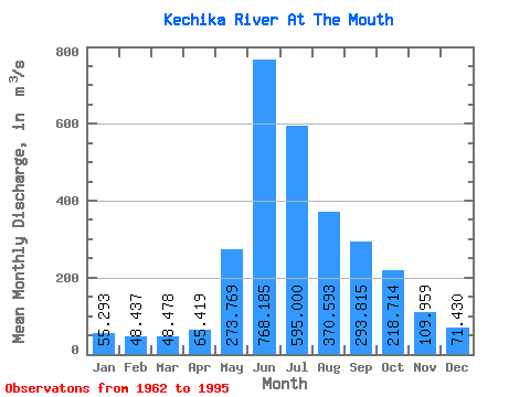
| Mean | 55.29 | 48.44 | 48.48 | 65.42 | 273.77 | 768.18 | 595.00 | 370.59 | 293.81 | 218.71 | 109.96 | 71.43 | 244.75 |
| Standard Deviation | 9.01 | 8.96 | 10.33 | 18.85 | 100.15 | 173.80 | 162.35 | 76.60 | 60.79 | 53.64 | 21.46 | 11.60 | 25.52 |
| Min | 40.10 | 27.70 | 26.50 | 37.80 | 122.00 | 528.00 | 292.00 | 257.00 | 179.00 | 153.00 | 78.60 | 55.50 | 180.05 |
| Max | 70.80 | 65.10 | 76.60 | 124.00 | 573.00 | 1250.00 | 909.00 | 581.00 | 396.00 | 370.00 | 168.00 | 110.00 | 280.24 |
| Coefficient of Variation | 0.16 | 0.18 | 0.21 | 0.29 | 0.37 | 0.23 | 0.27 | 0.21 | 0.21 | 0.24 | 0.20 | 0.16 | 0.10 |
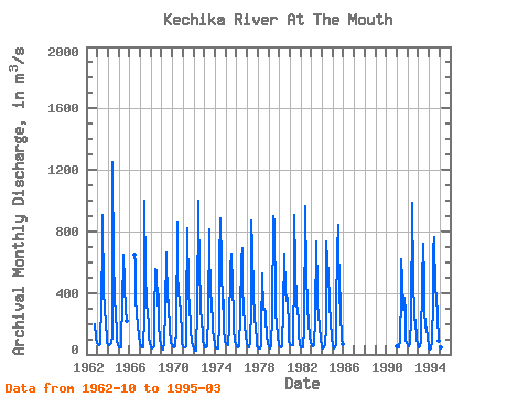
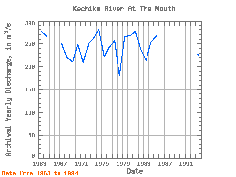
| Year | Jan | Feb | Mar | Apr | May | Jun | Jul | Aug | Sep | Oct | Nov | Dec | Annual | 1962 | 197.00 | 110.00 | 76.50 | 1963 | 70.80 | 65.10 | 59.50 | 65.20 | 337.00 | 727.00 | 909.00 | 403.00 | 305.00 | 190.00 | 119.00 | 76.50 | 277.26 | 1964 | 62.30 | 59.50 | 68.00 | 73.60 | 122.00 | 1250.00 | 599.00 | 407.00 | 225.00 | 180.00 | 93.00 | 62.30 | 266.81 | 1965 | 48.90 | 46.70 | 47.10 | 124.00 | 306.00 | 647.00 | 473.00 | 274.00 | 288.00 | 221.00 | 1966 | 650.00 | 588.00 | 373.00 | 253.00 | 194.00 | 116.00 | 77.60 | 1967 | 65.40 | 52.30 | 45.60 | 48.20 | 249.00 | 1000.00 | 537.00 | 339.00 | 257.00 | 219.00 | 101.00 | 76.00 | 249.12 | 1968 | 47.90 | 41.80 | 43.20 | 52.90 | 265.00 | 552.00 | 545.00 | 320.00 | 388.00 | 201.00 | 98.10 | 66.90 | 218.48 | 1969 | 41.80 | 35.50 | 35.80 | 73.80 | 295.00 | 661.00 | 341.00 | 400.00 | 322.00 | 171.00 | 78.60 | 71.50 | 210.58 | 1970 | 56.10 | 50.20 | 45.50 | 56.00 | 163.00 | 866.00 | 515.00 | 416.00 | 342.00 | 293.00 | 116.00 | 68.90 | 248.97 | 1971 | 53.50 | 48.50 | 45.30 | 52.80 | 265.00 | 821.00 | 427.00 | 283.00 | 213.00 | 153.00 | 82.10 | 62.70 | 208.91 | 1972 | 40.10 | 27.70 | 26.50 | 39.90 | 289.00 | 1000.00 | 489.00 | 408.00 | 261.00 | 258.00 | 94.80 | 59.90 | 249.49 | 1973 | 57.90 | 47.50 | 44.90 | 57.10 | 276.00 | 817.00 | 731.00 | 374.00 | 368.00 | 173.00 | 94.50 | 83.60 | 260.38 | 1974 | 64.20 | 42.30 | 36.90 | 37.80 | 202.00 | 606.00 | 882.00 | 581.00 | 300.00 | 358.00 | 168.00 | 84.70 | 280.24 | 1975 | 68.80 | 64.60 | 60.60 | 60.40 | 182.00 | 552.00 | 654.00 | 451.00 | 247.00 | 168.00 | 84.40 | 69.20 | 221.83 | 1976 | 57.30 | 50.10 | 46.20 | 56.70 | 257.00 | 626.00 | 693.00 | 428.00 | 312.00 | 193.00 | 116.00 | 72.10 | 242.28 | 1977 | 68.50 | 56.20 | 48.00 | 78.60 | 310.00 | 870.00 | 682.00 | 406.00 | 237.00 | 170.00 | 93.30 | 55.50 | 256.26 | 1978 | 48.90 | 42.60 | 39.30 | 60.20 | 157.00 | 528.00 | 292.00 | 298.00 | 271.00 | 231.00 | 117.00 | 75.60 | 180.05 | 1979 | 54.00 | 37.70 | 42.60 | 53.30 | 251.00 | 902.00 | 867.00 | 342.00 | 254.00 | 209.00 | 115.00 | 62.90 | 265.88 | 1980 | 51.10 | 52.10 | 49.00 | 51.50 | 300.00 | 648.00 | 656.00 | 422.00 | 349.00 | 370.00 | 164.00 | 89.30 | 266.83 | 1981 | 69.00 | 58.30 | 60.40 | 60.60 | 573.00 | 905.00 | 586.00 | 309.00 | 299.00 | 210.00 | 136.00 | 59.40 | 277.14 | 1982 | 44.10 | 45.90 | 49.00 | 53.30 | 160.00 | 965.00 | 510.00 | 325.00 | 314.00 | 206.00 | 118.00 | 72.40 | 238.56 | 1983 | 59.50 | 57.30 | 53.40 | 60.80 | 232.00 | 734.00 | 425.00 | 328.00 | 265.00 | 177.00 | 107.00 | 57.20 | 213.02 | 1984 | 44.20 | 42.90 | 47.90 | 66.60 | 176.00 | 736.00 | 605.00 | 530.00 | 351.00 | 199.00 | 134.00 | 110.00 | 253.55 | 1985 | 58.20 | 42.30 | 46.90 | 63.90 | 298.00 | 672.00 | 842.00 | 330.00 | 396.00 | 267.00 | 105.00 | 66.80 | 265.68 | 1991 | 50.80 | 49.00 | 49.80 | 91.60 | 400.00 | 618.00 | 475.00 | 293.00 | 366.00 | 269.00 | 100.00 | 78.40 | 236.72 | 1992 | 61.00 | 56.00 | 76.60 | 97.50 | 221.00 | 986.00 | 493.00 | 257.00 | 189.00 | 226.00 | 107.00 | 61.80 | 235.99 | 1993 | 49.70 | 51.00 | 50.50 | 80.00 | 468.00 | 721.00 | 482.00 | 295.00 | 179.00 | 174.00 | 108.00 | 64.10 | 226.86 | 1994 | 42.90 | 34.90 | 36.10 | 84.60 | 364.00 | 681.00 | 767.00 | 414.00 | 382.00 | 247.00 | 93.10 | 66.80 | 267.78 | 1995 | 56.00 | 49.80 | 54.30 |
|---|
| Other Close Sites | ||||||
|---|---|---|---|---|---|---|
| PointID | Latitude | Longitude | Drainage Area | Source | Name | |
| 2765 | "LIARD RIVER ABOVE KECHIKA RIVER" | 59.70 | 2014363 | Hydat | ||
 Return to R-Arctic Net Home Page