|
|
|||||||||||||||||
| Point ID: 2751 | Downloads | Plots | Site Data | Code: 10AC002 |
|
|
|||||||||||||||||
| Download | |
|---|---|
| Site Descriptor Information | Site Time Series Data |
| Link to all available data | |
|
|
| View: | Statistics | Time Series |
| Units: | mm |
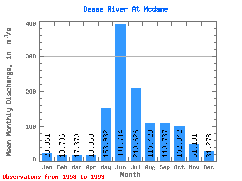
| Statistic | Jan | Feb | Mar | Apr | May | Jun | Jul | Aug | Sep | Oct | Nov | Dec | Annual |
|---|---|---|---|---|---|---|---|---|---|---|---|---|---|
| Mean | 23.36 | 19.71 | 17.37 | 19.36 | 153.93 | 391.71 | 210.63 | 110.43 | 110.74 | 102.34 | 51.19 | 31.28 | 102.53 |
| Standard Deviation | 4.20 | 3.45 | 3.38 | 5.70 | 60.72 | 98.50 | 72.45 | 38.68 | 37.66 | 43.65 | 18.52 | 6.97 | 14.07 |
| Min | 13.90 | 12.60 | 12.30 | 12.10 | 52.60 | 186.00 | 81.90 | 56.70 | 51.70 | 47.10 | 30.00 | 20.30 | 61.42 |
| Max | 34.70 | 27.10 | 26.20 | 34.30 | 290.00 | 602.00 | 389.00 | 209.00 | 213.00 | 271.00 | 101.00 | 49.60 | 127.97 |
| Coefficient of Variation | 0.18 | 0.17 | 0.20 | 0.29 | 0.39 | 0.25 | 0.34 | 0.35 | 0.34 | 0.43 | 0.36 | 0.22 | 0.14 |
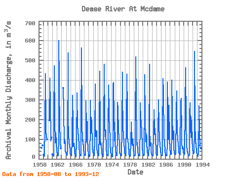
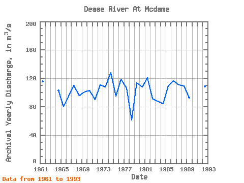
| Year | Jan | Feb | Mar | Apr | May | Jun | Jul | Aug | Sep | Oct | Nov | Dec | Annual | 1958 | 56.70 | 69.90 | 1959 | 21.00 | 16.20 | 13.40 | 15.80 | 159.00 | 432.00 | 167.00 | 143.00 | 113.00 | 100.00 | 1960 | 197.00 | 411.00 | 272.00 | 115.00 | 91.90 | 108.00 | 1961 | 24.90 | 18.70 | 15.30 | 15.00 | 207.00 | 474.00 | 198.00 | 80.80 | 108.00 | 132.00 | 81.10 | 38.20 | 116.08 | 1962 | 27.20 | 25.50 | 16.40 | 16.40 | 103.00 | 602.00 | 389.00 | 141.00 | 129.00 | 87.50 | 53.30 | 1963 | 361.00 | 249.00 | 79.00 | 99.20 | 79.40 | 40.50 | 31.10 | 1964 | 25.50 | 23.20 | 21.50 | 19.80 | 52.60 | 537.00 | 207.00 | 124.00 | 80.10 | 69.10 | 47.50 | 26.70 | 102.83 | 1965 | 24.30 | 21.00 | 16.30 | 15.60 | 95.50 | 322.00 | 166.00 | 64.20 | 80.10 | 78.10 | 47.00 | 30.10 | 80.02 | 1966 | 22.60 | 17.20 | 14.30 | 12.50 | 85.50 | 335.00 | 158.00 | 154.00 | 127.00 | 124.00 | 56.50 | 36.30 | 95.24 | 1967 | 25.30 | 20.60 | 16.70 | 16.30 | 138.00 | 564.00 | 181.00 | 88.50 | 98.70 | 93.70 | 48.70 | 32.00 | 110.29 | 1968 | 19.80 | 18.50 | 18.20 | 18.00 | 160.00 | 295.00 | 172.00 | 84.70 | 189.00 | 102.00 | 47.10 | 27.70 | 96.00 | 1969 | 13.90 | 12.60 | 12.30 | 18.20 | 165.00 | 297.00 | 130.00 | 209.00 | 181.00 | 78.30 | 52.70 | 39.70 | 100.81 | 1970 | 27.10 | 21.50 | 18.60 | 16.60 | 110.00 | 381.00 | 180.00 | 115.00 | 129.00 | 142.00 | 56.90 | 33.00 | 102.56 | 1971 | 22.70 | 19.50 | 16.90 | 15.80 | 131.00 | 445.00 | 143.00 | 70.80 | 87.70 | 66.50 | 35.60 | 25.30 | 89.98 | 1972 | 20.20 | 16.70 | 13.90 | 12.40 | 153.00 | 481.00 | 171.00 | 115.00 | 120.00 | 146.00 | 47.40 | 30.30 | 110.58 | 1973 | 23.70 | 21.10 | 17.60 | 16.80 | 142.00 | 374.00 | 236.00 | 139.00 | 181.00 | 82.30 | 32.60 | 27.20 | 107.78 | 1974 | 20.50 | 16.30 | 12.30 | 12.10 | 109.00 | 380.00 | 388.00 | 196.00 | 91.20 | 186.00 | 84.60 | 39.60 | 127.97 | 1975 | 27.30 | 23.10 | 18.50 | 16.30 | 118.00 | 287.00 | 252.00 | 143.00 | 113.00 | 79.40 | 33.80 | 27.50 | 94.91 | 1976 | 21.00 | 17.40 | 15.80 | 16.60 | 149.00 | 440.00 | 336.00 | 151.00 | 126.00 | 77.00 | 47.90 | 28.60 | 118.86 | 1977 | 25.70 | 21.60 | 17.30 | 26.00 | 178.00 | 430.00 | 250.00 | 110.00 | 97.40 | 66.30 | 31.60 | 20.30 | 106.18 | 1978 | 17.50 | 14.90 | 12.90 | 15.80 | 83.70 | 186.00 | 81.90 | 70.20 | 70.70 | 102.00 | 49.00 | 32.50 | 61.42 | 1979 | 24.90 | 17.20 | 17.10 | 18.50 | 163.00 | 519.00 | 295.00 | 93.30 | 71.90 | 83.90 | 35.70 | 24.60 | 113.67 | 1980 | 19.40 | 19.40 | 15.40 | 15.70 | 180.00 | 286.00 | 200.00 | 195.00 | 126.00 | 150.00 | 60.00 | 27.60 | 107.88 | 1981 | 19.70 | 16.20 | 17.80 | 19.90 | 290.00 | 429.00 | 212.00 | 86.30 | 129.00 | 111.00 | 81.00 | 39.00 | 120.91 | 1982 | 25.70 | 25.70 | 21.00 | 17.50 | 73.50 | 481.00 | 162.00 | 66.50 | 82.10 | 80.40 | 35.70 | 21.60 | 91.06 | 1983 | 17.00 | 16.20 | 15.50 | 15.80 | 136.00 | 250.00 | 153.00 | 123.00 | 154.00 | 98.70 | 42.50 | 28.40 | 87.51 | 1984 | 22.10 | 20.00 | 19.10 | 23.10 | 113.00 | 300.00 | 170.00 | 104.00 | 101.00 | 72.80 | 38.10 | 26.10 | 84.11 | 1985 | 20.10 | 17.40 | 16.90 | 19.10 | 123.00 | 407.00 | 342.00 | 102.00 | 114.00 | 86.90 | 38.50 | 24.50 | 109.28 | 1986 | 23.80 | 16.30 | 16.20 | 15.60 | 80.90 | 389.00 | 238.00 | 98.10 | 102.00 | 271.00 | 101.00 | 49.60 | 116.79 | 1987 | 33.40 | 24.80 | 23.00 | 23.50 | 136.00 | 401.00 | 237.00 | 99.10 | 125.00 | 141.00 | 53.20 | 28.70 | 110.47 | 1988 | 23.40 | 22.00 | 20.50 | 26.60 | 230.00 | 345.00 | 246.00 | 145.00 | 96.10 | 79.00 | 44.90 | 34.00 | 109.38 | 1989 | 25.70 | 23.20 | 20.90 | 32.20 | 290.00 | 307.00 | 134.00 | 80.30 | 51.70 | 61.80 | 46.20 | 37.70 | 92.56 | 1990 | 26.40 | 22.20 | 25.10 | 26.90 | 261.00 | 464.00 | 171.00 | 75.30 | 62.20 | 47.10 | 30.00 | 27.50 | 103.22 | 1991 | 22.00 | 19.30 | 15.80 | 23.10 | 227.00 | 284.00 | 154.00 | 108.00 | 213.00 | 178.00 | 99.00 | 49.60 | 116.07 | 1992 | 34.70 | 27.10 | 26.20 | 34.30 | 147.00 | 545.00 | 195.00 | 79.40 | 80.30 | 76.40 | 34.60 | 27.30 | 108.94 | 1993 | 22.40 | 17.70 | 14.50 | 31.00 | 247.00 | 269.00 | 136.00 | 70.20 | 54.50 | 76.80 | 55.10 | 28.60 | 85.23 |
|---|
 Return to R-Arctic Net Home Page