|
|
|||||||||||||||||
| Point ID: 2743 | Downloads | Plots | Site Data | Code: 09AA006 |
|
|
|||||||||||||||||
| Download | |
|---|---|
| Site Descriptor Information | Site Time Series Data |
| Link to all available data | |
|
|
| View: | Statistics | Time Series |
| Units: | mm |
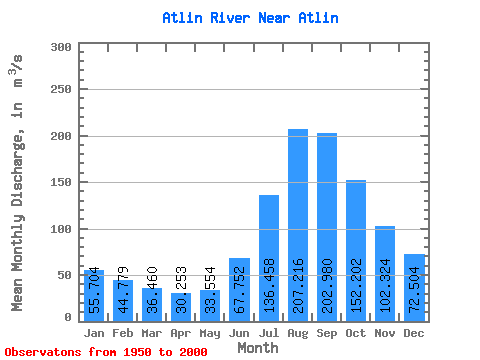
| Statistic | Jan | Feb | Mar | Apr | May | Jun | Jul | Aug | Sep | Oct | Nov | Dec | Annual |
|---|---|---|---|---|---|---|---|---|---|---|---|---|---|
| Mean | 55.70 | 44.78 | 36.46 | 30.25 | 33.55 | 67.75 | 136.46 | 207.22 | 202.98 | 152.20 | 102.32 | 72.50 | 95.45 |
| Standard Deviation | 8.73 | 6.96 | 5.75 | 4.89 | 6.97 | 17.38 | 28.18 | 36.00 | 35.71 | 28.72 | 17.45 | 11.90 | 14.48 |
| Min | 38.10 | 30.40 | 25.50 | 20.30 | 22.30 | 32.30 | 84.50 | 143.00 | 135.00 | 96.30 | 64.90 | 48.20 | 65.18 |
| Max | 71.30 | 58.30 | 54.80 | 47.70 | 50.30 | 117.00 | 202.00 | 279.00 | 286.00 | 205.00 | 136.00 | 94.80 | 124.65 |
| Coefficient of Variation | 0.16 | 0.15 | 0.16 | 0.16 | 0.21 | 0.26 | 0.21 | 0.17 | 0.18 | 0.19 | 0.17 | 0.16 | 0.15 |
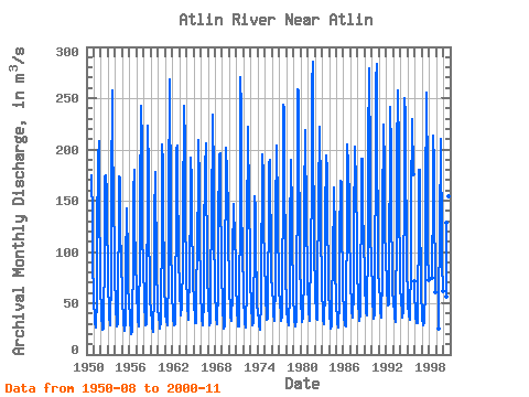
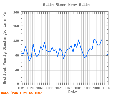
| Year | Jan | Feb | Mar | Apr | May | Jun | Jul | Aug | Sep | Oct | Nov | Dec | Annual | 1950 | 165.00 | 175.00 | 132.00 | 87.80 | 60.40 | 1951 | 48.70 | 38.30 | 31.50 | 26.50 | 29.60 | 52.30 | 117.00 | 191.00 | 208.00 | 137.00 | 89.50 | 62.20 | 85.97 | 1952 | 46.10 | 36.00 | 28.30 | 24.70 | 25.30 | 40.30 | 90.10 | 173.00 | 175.00 | 158.00 | 124.00 | 87.30 | 84.01 | 1953 | 62.80 | 48.50 | 37.80 | 29.00 | 34.20 | 71.90 | 159.00 | 258.00 | 220.00 | 145.00 | 104.00 | 71.70 | 103.49 | 1954 | 51.70 | 43.00 | 34.70 | 27.50 | 31.00 | 76.00 | 123.00 | 174.00 | 172.00 | 127.00 | 85.30 | 63.50 | 84.06 | 1955 | 49.50 | 38.40 | 29.80 | 25.10 | 23.30 | 32.30 | 87.70 | 143.00 | 135.00 | 101.00 | 67.30 | 49.80 | 65.18 | 1956 | 38.10 | 30.40 | 25.50 | 20.30 | 22.30 | 42.10 | 84.50 | 156.00 | 180.00 | 133.00 | 86.90 | 67.20 | 73.86 | 1957 | 55.40 | 42.70 | 34.30 | 27.20 | 35.70 | 97.70 | 165.00 | 224.00 | 243.00 | 205.00 | 123.00 | 80.70 | 111.14 | 1958 | 58.50 | 44.70 | 36.40 | 28.20 | 29.50 | 62.60 | 151.00 | 223.00 | 178.00 | 113.00 | 77.50 | 54.30 | 88.06 | 1959 | 41.40 | 34.00 | 27.80 | 22.40 | 23.50 | 60.60 | 134.00 | 178.00 | 148.00 | 110.00 | 77.00 | 58.20 | 76.24 | 1960 | 44.10 | 36.20 | 30.10 | 24.90 | 31.50 | 58.20 | 109.00 | 205.00 | 185.00 | 130.00 | 88.90 | 63.10 | 83.83 | 1961 | 47.70 | 39.50 | 33.20 | 28.20 | 33.90 | 75.20 | 151.00 | 268.00 | 247.00 | 161.00 | 104.00 | 69.40 | 104.84 | 1962 | 54.80 | 44.90 | 34.90 | 28.40 | 29.20 | 61.40 | 128.00 | 200.00 | 204.00 | 157.00 | 113.00 | 88.80 | 95.37 | 1963 | 69.80 | 57.00 | 45.90 | 38.30 | 46.30 | 89.40 | 154.00 | 222.00 | 242.00 | 205.00 | 129.00 | 90.90 | 115.80 | 1964 | 70.90 | 56.40 | 45.50 | 36.90 | 33.80 | 86.40 | 146.00 | 192.00 | 168.00 | 121.00 | 88.90 | 66.90 | 92.72 | 1965 | 54.40 | 46.80 | 38.40 | 30.70 | 31.10 | 56.70 | 109.00 | 168.00 | 209.00 | 165.00 | 108.00 | 75.00 | 91.01 | 1966 | 54.40 | 43.70 | 35.50 | 28.80 | 29.30 | 51.70 | 111.00 | 181.00 | 206.00 | 163.00 | 107.00 | 71.70 | 90.26 | 1967 | 56.40 | 45.40 | 37.10 | 28.60 | 31.50 | 69.00 | 134.00 | 226.00 | 234.00 | 173.00 | 110.00 | 74.80 | 101.65 | 1968 | 55.40 | 44.10 | 36.70 | 29.90 | 31.60 | 63.20 | 124.00 | 194.00 | 196.00 | 149.00 | 101.00 | 71.80 | 91.39 | 1969 | 56.20 | 42.20 | 31.20 | 25.40 | 28.70 | 85.40 | 177.00 | 202.00 | 176.00 | 139.00 | 101.00 | 81.20 | 95.44 | 1970 | 59.60 | 47.60 | 37.50 | 32.50 | 33.20 | 61.10 | 96.80 | 147.00 | 140.00 | 117.00 | 87.80 | 63.70 | 76.98 | 1971 | 49.20 | 41.30 | 33.70 | 27.90 | 27.30 | 56.20 | 137.00 | 270.00 | 238.00 | 152.00 | 95.20 | 65.40 | 99.43 | 1972 | 50.00 | 39.50 | 30.80 | 26.10 | 26.30 | 66.90 | 128.00 | 211.00 | 222.00 | 148.00 | 97.70 | 67.10 | 92.78 | 1973 | 53.10 | 42.80 | 35.70 | 28.80 | 31.20 | 51.40 | 99.30 | 154.00 | 142.00 | 96.30 | 64.90 | 48.20 | 70.64 | 1974 | 41.30 | 33.30 | 28.20 | 24.50 | 26.80 | 50.90 | 97.40 | 158.00 | 195.00 | 175.00 | 130.00 | 87.40 | 87.32 | 1975 | 64.90 | 51.40 | 42.50 | 34.20 | 35.40 | 57.10 | 142.00 | 185.00 | 190.00 | 166.00 | 107.00 | 76.50 | 96.00 | 1976 | 61.80 | 51.30 | 40.70 | 32.70 | 37.00 | 65.60 | 135.00 | 204.00 | 188.00 | 157.00 | 115.00 | 82.30 | 97.53 | 1977 | 63.50 | 49.80 | 39.40 | 32.70 | 36.80 | 74.20 | 151.00 | 244.00 | 239.00 | 165.00 | 108.00 | 72.10 | 106.29 | 1978 | 53.20 | 42.60 | 34.30 | 28.40 | 31.30 | 58.30 | 116.00 | 190.00 | 189.00 | 137.00 | 102.00 | 72.30 | 87.87 | 1979 | 52.60 | 42.40 | 33.90 | 27.70 | 34.00 | 66.10 | 165.00 | 259.00 | 258.00 | 190.00 | 125.00 | 84.90 | 111.55 | 1980 | 60.30 | 49.00 | 38.90 | 31.50 | 37.60 | 78.20 | 148.00 | 219.00 | 184.00 | 163.00 | 124.00 | 85.70 | 101.60 | 1981 | 63.00 | 53.60 | 43.50 | 33.10 | 43.50 | 95.70 | 167.00 | 263.00 | 286.00 | 199.00 | 128.00 | 94.80 | 122.52 | 1982 | 68.30 | 55.40 | 43.70 | 34.70 | 33.80 | 70.90 | 151.00 | 222.00 | 215.00 | 164.00 | 110.00 | 81.50 | 104.19 | 1983 | 59.40 | 43.60 | 34.60 | 29.70 | 31.60 | 63.00 | 133.00 | 194.00 | 180.00 | 126.00 | 86.70 | 59.30 | 86.74 | 1984 | 44.70 | 37.30 | 31.50 | 25.50 | 27.60 | 49.40 | 94.10 | 155.00 | 163.00 | 117.00 | 80.40 | 57.40 | 73.58 | 1985 | 46.10 | 38.10 | 31.10 | 26.40 | 25.90 | 52.10 | 109.00 | 169.00 | 168.00 | 121.00 | 77.50 | 57.60 | 76.82 | 1986 | 44.60 | 34.80 | 31.90 | 28.90 | 27.50 | 53.80 | 128.00 | 205.00 | 183.00 | 150.00 | 115.00 | 83.10 | 90.47 | 1987 | 65.50 | 53.30 | 43.30 | 35.60 | 35.80 | 60.50 | 130.00 | 196.00 | 203.00 | 164.00 | 113.00 | 79.20 | 98.27 | 1988 | 58.60 | 47.50 | 39.30 | 32.70 | 40.50 | 79.30 | 136.00 | 191.00 | 191.00 | 145.00 | 106.00 | 81.80 | 95.72 | 1989 | 62.00 | 50.70 | 40.80 | 38.00 | 50.30 | 102.00 | 202.00 | 279.00 | 263.00 | 201.00 | 122.00 | 85.00 | 124.65 | 1990 | 66.10 | 50.40 | 41.00 | 34.50 | 40.60 | 94.90 | 175.00 | 267.00 | 283.00 | 203.00 | 117.00 | 81.90 | 121.20 | 1991 | 65.70 | 54.70 | 43.20 | 36.00 | 42.40 | 70.90 | 145.00 | 217.00 | 224.00 | 182.00 | 124.00 | 91.80 | 108.06 | 1992 | 71.30 | 58.30 | 54.80 | 47.70 | 49.30 | 99.80 | 194.00 | 241.00 | 198.00 | 128.00 | 89.60 | 65.60 | 108.12 | 1993 | 47.80 | 43.30 | 36.90 | 31.80 | 46.80 | 117.00 | 194.00 | 257.00 | 248.00 | 205.00 | 136.00 | 91.70 | 121.28 | 1994 | 65.20 | 51.80 | 42.30 | 36.10 | 42.50 | 77.10 | 155.00 | 250.00 | 234.00 | 185.00 | 116.00 | 77.10 | 111.01 | 1995 | 65.40 | 50.20 | 38.70 | 33.80 | 45.40 | 79.90 | 162.00 | 217.00 | 230.00 | 176.00 | 71.30 | 1996 | 56.30 | 43.60 | 36.70 | 30.80 | 30.90 | 57.60 | 117.00 | 180.00 | 180.00 | 126.00 | 81.50 | 56.30 | 83.06 | 1997 | 42.30 | 34.80 | 30.10 | 28.60 | 32.20 | 64.60 | 154.00 | 249.00 | 255.00 | 170.00 | 102.00 | 72.30 | 102.91 | 1998 | 75.20 | 158.00 | 213.00 | 185.00 | 126.00 | 89.50 | 61.20 | 1999 | 25.80 | 48.80 | 120.00 | 210.00 | 186.00 | 130.00 | 89.30 | 61.80 | 2000 | 56.70 | 129.00 | 209.00 | 191.00 | 154.00 | 103.00 |
|---|
 Return to R-Arctic Net Home Page