|
|
|||||||||||||||||
| Point ID: 271 | Downloads | Plots | Site Data | Code: 05BF022 |
|
|
|||||||||||||||||
| Download | |
|---|---|
| Site Descriptor Information | Site Time Series Data |
| Link to all available data | |

|
|
| View: | Statistics | Time Series |
| Units: | mm |
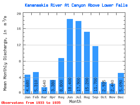
| Statistic | Jan | Feb | Mar | Apr | May | Jun | Jul | Aug | Sep | Oct | Nov | Dec | Annual |
|---|---|---|---|---|---|---|---|---|---|---|---|---|---|
| Mean | 4.68 | 5.31 | 1.64 | 3.38 | 8.80 | 18.40 | 17.90 | 15.20 | 11.70 | 2.94 | 2.44 | 5.09 | |
| Standard Deviation | 7.92 | 2.12 | 0.54 | 0.38 | |||||||||
| Min | 4.68 | 5.31 | 1.64 | 3.38 | 3.20 | 16.90 | 17.90 | 15.20 | 11.70 | 2.55 | 2.17 | 5.09 | |
| Max | 4.68 | 5.31 | 1.64 | 3.38 | 14.40 | 19.90 | 17.90 | 15.20 | 11.70 | 3.32 | 2.71 | 5.09 | |
| Coefficient of Variation | 0.90 | 0.12 | 0.19 | 0.16 |
| Year | Jan | Feb | Mar | Apr | May | Jun | Jul | Aug | Sep | Oct | Nov | Dec | Annual | 1933 | 3.32 | 2.17 | 5.09 | 1934 | 4.68 | 5.31 | 1.64 | 3.38 | 14.40 | 19.90 | 17.90 | 15.20 | 11.70 | 2.55 | 2.71 | 1935 | 3.20 | 16.90 |
|---|
 Return to R-Arctic Net Home Page