|
|
|||||||||||||||||
| Point ID: 250 | Downloads | Plots | Site Data | Code: 05BE004 |
|
|
|||||||||||||||||
| Download | |
|---|---|
| Site Descriptor Information | Site Time Series Data |
| Link to all available data | |
|
|
| View: | Statistics | Time Series |
| Units: | mm |
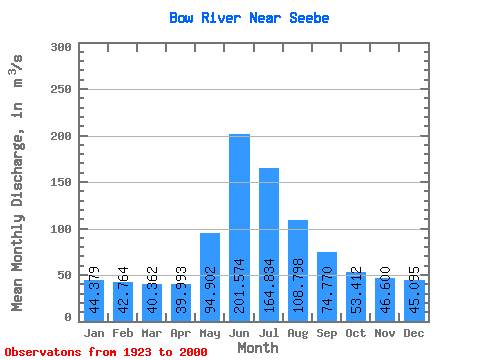
| Statistic | Jan | Feb | Mar | Apr | May | Jun | Jul | Aug | Sep | Oct | Nov | Dec | Annual |
|---|---|---|---|---|---|---|---|---|---|---|---|---|---|
| Mean | 44.38 | 42.76 | 40.36 | 39.99 | 94.90 | 201.57 | 164.83 | 108.80 | 74.77 | 53.41 | 46.60 | 45.09 | 79.80 |
| Standard Deviation | 14.14 | 13.62 | 13.55 | 11.48 | 32.73 | 64.94 | 46.94 | 23.16 | 15.44 | 10.30 | 11.20 | 13.00 | 11.74 |
| Min | 16.60 | 19.40 | 15.80 | 18.50 | 40.30 | 115.00 | 92.90 | 74.60 | 53.10 | 34.40 | 26.70 | 23.90 | 54.63 |
| Max | 69.00 | 67.70 | 70.90 | 62.20 | 194.00 | 413.00 | 295.00 | 182.00 | 123.00 | 81.00 | 69.90 | 72.20 | 105.07 |
| Coefficient of Variation | 0.32 | 0.32 | 0.34 | 0.29 | 0.34 | 0.32 | 0.28 | 0.21 | 0.21 | 0.19 | 0.24 | 0.29 | 0.15 |
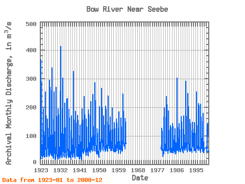
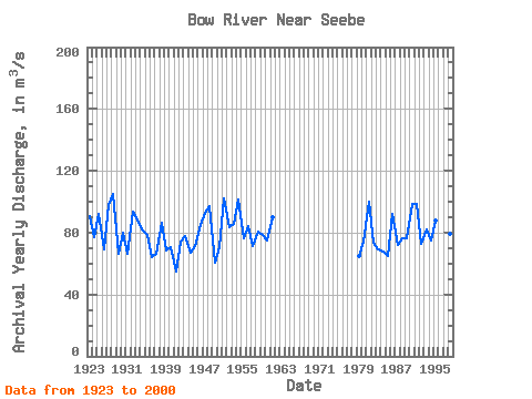
| Year | Jan | Feb | Mar | Apr | May | Jun | Jul | Aug | Sep | Oct | Nov | Dec | Annual | 1923 | 23.80 | 21.30 | 19.70 | 23.40 | 77.30 | 367.00 | 214.00 | 140.00 | 91.30 | 49.10 | 31.10 | 28.50 | 90.54 | 1924 | 26.00 | 27.30 | 26.20 | 26.00 | 111.00 | 178.00 | 194.00 | 149.00 | 79.20 | 45.20 | 32.80 | 27.90 | 76.88 | 1925 | 27.60 | 26.80 | 25.60 | 39.10 | 160.00 | 254.00 | 192.00 | 148.00 | 95.60 | 61.90 | 41.40 | 31.60 | 91.97 | 1926 | 27.70 | 30.30 | 28.20 | 38.40 | 71.50 | 115.00 | 158.00 | 94.00 | 118.00 | 72.10 | 45.30 | 34.30 | 69.40 | 1927 | 28.30 | 27.40 | 27.00 | 30.50 | 60.30 | 295.00 | 245.00 | 161.00 | 123.00 | 81.00 | 54.30 | 39.80 | 97.72 | 1928 | 40.40 | 34.20 | 32.00 | 32.00 | 180.00 | 338.00 | 295.00 | 132.00 | 75.50 | 43.90 | 32.80 | 25.00 | 105.07 | 1929 | 21.70 | 22.90 | 25.40 | 22.00 | 62.60 | 253.00 | 129.00 | 101.00 | 62.60 | 39.50 | 33.80 | 26.30 | 66.65 | 1930 | 16.60 | 19.40 | 18.00 | 29.90 | 89.00 | 269.00 | 213.00 | 125.00 | 78.40 | 41.30 | 29.40 | 27.10 | 79.67 | 1931 | 30.00 | 24.00 | 19.00 | 18.90 | 79.70 | 194.00 | 154.00 | 102.00 | 79.40 | 40.90 | 26.90 | 27.50 | 66.36 | 1932 | 21.10 | 26.60 | 23.40 | 26.00 | 99.20 | 413.00 | 184.00 | 131.00 | 86.60 | 49.20 | 35.50 | 29.00 | 93.72 | 1933 | 26.10 | 23.30 | 25.50 | 32.50 | 86.80 | 302.00 | 240.00 | 127.00 | 85.30 | 48.90 | 38.20 | 28.80 | 88.70 | 1934 | 29.90 | 26.80 | 25.80 | 58.90 | 194.00 | 214.00 | 151.00 | 104.00 | 69.50 | 45.70 | 34.90 | 26.80 | 81.78 | 1935 | 32.00 | 22.70 | 24.70 | 31.70 | 61.60 | 227.00 | 231.00 | 135.00 | 65.30 | 40.00 | 31.50 | 37.00 | 78.29 | 1936 | 27.90 | 26.00 | 23.40 | 25.70 | 106.00 | 193.00 | 132.00 | 91.60 | 54.00 | 34.40 | 26.70 | 25.70 | 63.87 | 1937 | 27.40 | 27.30 | 17.10 | 18.50 | 67.50 | 170.00 | 166.00 | 110.00 | 71.50 | 49.20 | 43.10 | 28.60 | 66.35 | 1938 | 26.90 | 25.10 | 25.40 | 25.10 | 109.00 | 325.00 | 212.00 | 98.20 | 80.20 | 48.00 | 30.10 | 34.60 | 86.63 | 1939 | 28.20 | 28.40 | 27.00 | 23.10 | 95.30 | 146.00 | 186.00 | 103.00 | 68.10 | 48.60 | 41.50 | 30.40 | 68.80 | 1940 | 34.90 | 33.60 | 28.80 | 28.40 | 113.00 | 172.00 | 136.00 | 92.20 | 91.00 | 49.60 | 34.70 | 29.90 | 70.34 | 1941 | 22.90 | 21.00 | 19.60 | 22.40 | 63.30 | 137.00 | 113.00 | 92.20 | 65.50 | 44.90 | 29.90 | 23.90 | 54.63 | 1942 | 22.90 | 24.70 | 15.80 | 18.90 | 102.00 | 186.00 | 194.00 | 117.00 | 71.10 | 47.90 | 38.70 | 48.80 | 73.98 | 1943 | 40.70 | 46.70 | 44.40 | 42.50 | 64.50 | 142.00 | 238.00 | 108.00 | 59.50 | 50.20 | 48.20 | 46.70 | 77.62 | 1944 | 42.40 | 43.00 | 40.50 | 31.60 | 74.30 | 159.00 | 102.00 | 105.00 | 68.00 | 46.60 | 45.60 | 44.60 | 66.88 | 1945 | 43.70 | 39.20 | 35.60 | 29.40 | 59.00 | 191.00 | 161.00 | 90.40 | 62.40 | 47.10 | 47.70 | 46.90 | 71.12 | 1946 | 46.30 | 47.20 | 41.40 | 43.20 | 121.00 | 219.00 | 152.00 | 98.40 | 88.20 | 57.60 | 51.80 | 51.20 | 84.78 | 1947 | 51.30 | 49.70 | 46.00 | 50.90 | 140.00 | 245.00 | 173.00 | 91.60 | 81.00 | 75.00 | 58.40 | 51.50 | 92.78 | 1948 | 48.90 | 48.20 | 48.30 | 47.00 | 156.00 | 286.00 | 161.00 | 143.00 | 81.30 | 51.80 | 45.30 | 46.10 | 96.91 | 1949 | 45.70 | 41.90 | 37.10 | 36.70 | 99.50 | 124.00 | 92.90 | 82.20 | 57.20 | 37.40 | 37.30 | 37.40 | 60.77 | 1950 | 38.40 | 28.00 | 24.70 | 25.20 | 40.30 | 201.00 | 179.00 | 91.50 | 63.90 | 54.10 | 52.50 | 51.20 | 70.82 | 1951 | 47.50 | 44.80 | 53.40 | 56.90 | 121.00 | 183.00 | 267.00 | 132.00 | 104.00 | 77.80 | 69.90 | 64.90 | 101.85 | 1952 | 59.70 | 46.60 | 49.70 | 62.20 | 111.00 | 169.00 | 160.00 | 113.00 | 69.00 | 56.40 | 52.30 | 52.00 | 83.41 | 1953 | 53.70 | 52.80 | 46.50 | 47.40 | 81.80 | 203.00 | 182.00 | 104.00 | 74.40 | 59.20 | 62.40 | 56.60 | 85.32 | 1954 | 58.40 | 49.00 | 46.50 | 54.40 | 96.10 | 199.00 | 240.00 | 155.00 | 120.00 | 72.80 | 65.10 | 63.40 | 101.64 | 1955 | 59.90 | 57.10 | 55.60 | 57.60 | 59.60 | 166.00 | 153.00 | 85.50 | 62.50 | 47.20 | 50.80 | 59.60 | 76.20 | 1956 | 63.90 | 60.10 | 58.80 | 50.10 | 111.00 | 198.00 | 149.00 | 94.90 | 68.20 | 59.70 | 49.50 | 48.00 | 84.27 | 1957 | 46.40 | 49.80 | 50.30 | 44.70 | 126.00 | 146.00 | 103.00 | 74.60 | 61.60 | 57.70 | 44.60 | 50.00 | 71.22 | 1958 | 56.10 | 67.30 | 59.20 | 47.20 | 117.00 | 159.00 | 132.00 | 96.20 | 61.50 | 60.20 | 62.50 | 53.10 | 80.94 | 1959 | 63.90 | 56.00 | 38.50 | 43.00 | 68.30 | 183.00 | 157.00 | 89.80 | 71.40 | 53.70 | 52.60 | 66.30 | 78.62 | 1960 | 63.40 | 54.60 | 47.00 | 38.60 | 66.70 | 152.00 | 162.00 | 98.20 | 61.60 | 51.70 | 52.10 | 54.20 | 75.17 | 1961 | 46.20 | 52.80 | 47.40 | 51.00 | 114.00 | 246.00 | 125.00 | 118.00 | 72.40 | 68.60 | 64.90 | 72.20 | 89.88 | 1962 | 69.00 | 67.70 | 70.90 | 55.40 | 65.20 | 161.00 | 137.00 | 106.00 | 74.00 | 1979 | 56.60 | 65.60 | 59.10 | 48.40 | 62.20 | 126.00 | 106.00 | 84.00 | 65.80 | 39.20 | 28.60 | 35.20 | 64.72 | 1980 | 38.30 | 39.40 | 36.70 | 36.80 | 134.00 | 198.00 | 103.00 | 80.50 | 61.60 | 54.90 | 49.60 | 54.60 | 73.95 | 1981 | 60.30 | 55.00 | 46.50 | 45.20 | 141.00 | 189.00 | 238.00 | 182.00 | 90.00 | 50.10 | 50.90 | 47.70 | 99.64 | 1982 | 51.90 | 46.10 | 39.30 | 42.20 | 50.00 | 188.00 | 149.00 | 89.30 | 68.00 | 52.10 | 53.00 | 54.70 | 73.63 | 1983 | 55.30 | 51.10 | 49.40 | 42.50 | 70.30 | 136.00 | 123.00 | 99.70 | 67.50 | 47.80 | 45.10 | 41.70 | 69.12 | 1984 | 50.30 | 55.20 | 43.50 | 41.20 | 41.50 | 142.00 | 122.00 | 94.60 | 78.10 | 53.50 | 47.70 | 43.20 | 67.73 | 1985 | 40.80 | 44.50 | 49.70 | 45.30 | 78.00 | 124.00 | 124.00 | 82.40 | 71.70 | 41.20 | 36.80 | 42.00 | 65.03 | 1986 | 48.00 | 50.20 | 51.60 | 48.90 | 99.90 | 302.00 | 157.00 | 99.90 | 66.00 | 48.60 | 59.30 | 71.90 | 91.94 | 1987 | 67.40 | 55.00 | 48.20 | 43.60 | 142.00 | 137.00 | 105.00 | 75.50 | 53.10 | 45.90 | 46.50 | 45.60 | 72.07 | 1988 | 48.30 | 44.50 | 48.60 | 61.50 | 105.00 | 167.00 | 128.00 | 90.90 | 63.50 | 60.40 | 52.90 | 43.70 | 76.19 | 1989 | 46.10 | 48.90 | 46.40 | 40.30 | 75.90 | 169.00 | 119.00 | 117.00 | 88.00 | 59.10 | 55.50 | 50.40 | 76.30 | 1990 | 49.40 | 52.20 | 57.90 | 53.50 | 95.80 | 292.00 | 218.00 | 120.00 | 72.50 | 60.90 | 60.50 | 49.70 | 98.53 | 1991 | 49.80 | 50.70 | 49.10 | 44.00 | 107.00 | 232.00 | 249.00 | 155.00 | 78.10 | 62.90 | 58.20 | 50.70 | 98.88 | 1992 | 51.90 | 50.20 | 48.80 | 46.50 | 91.30 | 156.00 | 130.00 | 85.60 | 55.10 | 55.20 | 51.70 | 47.70 | 72.50 | 1993 | 50.20 | 47.40 | 49.50 | 41.60 | 106.00 | 129.00 | 148.00 | 123.00 | 96.20 | 64.70 | 63.20 | 64.90 | 81.97 | 1994 | 63.90 | 61.30 | 54.50 | 48.00 | 102.00 | 146.00 | 120.00 | 96.90 | 57.70 | 48.70 | 47.40 | 54.50 | 75.08 | 1995 | 52.80 | 47.10 | 50.30 | 41.30 | 68.20 | 254.00 | 149.00 | 122.00 | 84.50 | 65.10 | 64.40 | 57.00 | 87.97 | 1996 | 62.30 | 58.20 | 50.00 | 50.50 | 71.50 | 213.00 | 200.00 | 111.00 | 62.70 | 57.00 | 56.90 | 58.60 | 87.64 | 1997 | 56.90 | 49.40 | 51.40 | 42.50 | 79.10 | 211.00 | 122.00 | 101.00 | 81.20 | 71.20 | 56.00 | 64.80 | 82.21 | 1998 | 59.70 | 53.80 | 52.10 | 45.20 | 123.00 | 179.00 | 135.00 | 96.00 | 62.10 | 48.00 | 40.60 | 55.50 | 79.17 | 2000 | 59.10 | 61.20 | 60.10 | 44.20 | 63.90 | 126.00 | 145.00 | 99.90 | 64.40 | 52.10 | 45.10 | 44.20 | 72.10 |
|---|
 Return to R-Arctic Net Home Page