|
|
|||||||||||||||||
| Point ID: 248 | Downloads | Plots | Site Data | Code: 05BE001 |
|
|
|||||||||||||||||
| Download | |
|---|---|
| Site Descriptor Information | Site Time Series Data |
| Link to all available data | |
|
|
| View: | Statistics | Time Series |
| Units: | mm |
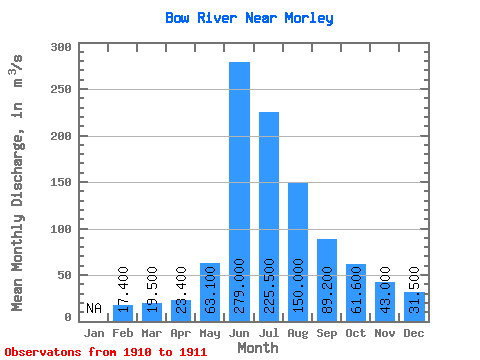
| Statistic | Jan | Feb | Mar | Apr | May | Jun | Jul | Aug | Sep | Oct | Nov | Dec | Annual |
|---|---|---|---|---|---|---|---|---|---|---|---|---|---|
| Mean | 17.40 | 19.50 | 23.40 | 63.10 | 279.00 | 225.50 | 150.00 | 89.20 | 61.60 | 43.00 | 31.50 | ||
| Standard Deviation | 12.73 | 3.54 | 18.39 | 14.14 | 13.44 | ||||||||
| Min | 17.40 | 19.50 | 23.40 | 63.10 | 270.00 | 223.00 | 137.00 | 79.20 | 52.10 | 43.00 | 31.50 | ||
| Max | 17.40 | 19.50 | 23.40 | 63.10 | 288.00 | 228.00 | 163.00 | 99.20 | 71.10 | 43.00 | 31.50 | ||
| Coefficient of Variation | 0.05 | 0.02 | 0.12 | 0.16 | 0.22 |
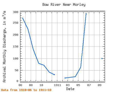
| Year | Jan | Feb | Mar | Apr | May | Jun | Jul | Aug | Sep | Oct | Nov | Dec | Annual | 1910 | 270.00 | 223.00 | 137.00 | 79.20 | 71.10 | 43.00 | 31.50 | 1911 | 17.40 | 19.50 | 23.40 | 63.10 | 288.00 | 228.00 | 163.00 | 99.20 | 52.10 |
|---|
 Return to R-Arctic Net Home Page