|
|
|||||||||||||||||
| Point ID: 226 | Downloads | Plots | Site Data | Code: 05BA004 |
|
|
|||||||||||||||||
| Download | |
|---|---|
| Site Descriptor Information | Site Time Series Data |
| Link to all available data | |
|
|
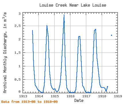
| View: | Statistics | Time Series |
| Units: | mm |
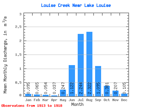
| Statistic | Jan | Feb | Mar | Apr | May | Jun | Jul | Aug | Sep | Oct | Nov | Dec | Annual |
|---|---|---|---|---|---|---|---|---|---|---|---|---|---|
| Mean | 0.10 | 0.07 | 0.05 | 0.04 | 0.25 | 1.12 | 2.24 | 2.32 | 1.09 | 0.38 | 0.21 | 0.10 | 0.65 |
| Standard Deviation | 0.08 | 0.07 | 0.07 | 0.04 | 0.08 | 0.28 | 0.24 | 0.31 | 0.18 | 0.27 | 0.08 | 0.07 | 0.06 |
| Min | 0.01 | 0.01 | 0.01 | 0.01 | 0.12 | 0.81 | 1.91 | 2.08 | 0.84 | 0.18 | 0.10 | 0.02 | 0.60 |
| Max | 0.19 | 0.20 | 0.18 | 0.10 | 0.33 | 1.57 | 2.51 | 2.91 | 1.32 | 0.86 | 0.32 | 0.21 | 0.73 |
| Coefficient of Variation | 0.86 | 1.14 | 1.34 | 1.10 | 0.32 | 0.25 | 0.11 | 0.14 | 0.16 | 0.71 | 0.39 | 0.71 | 0.09 |
| Year | Jan | Feb | Mar | Apr | May | Jun | Jul | Aug | Sep | Oct | Nov | Dec | Annual | 1913 | 2.33 | 1.06 | 0.29 | 0.23 | 0.12 | 1914 | 0.09 | 0.04 | 0.01 | 0.01 | 0.29 | 1.12 | 2.51 | 2.08 | 0.84 | 0.29 | 0.18 | 0.12 | 0.63 | 1915 | 0.16 | 0.06 | 0.04 | 0.10 | 0.33 | 0.81 | 1.91 | 2.91 | 1.09 | 0.18 | 0.10 | 0.02 | 0.64 | 1916 | 0.02 | 0.01 | 0.01 | 0.02 | 0.12 | 1.06 | 2.09 | 2.10 | 1.27 | 0.27 | 0.19 | 0.05 | 0.60 | 1917 | 0.01 | 0.03 | 0.02 | 0.01 | 0.27 | 1.05 | 2.32 | 2.37 | 1.32 | 0.86 | 0.32 | 0.21 | 0.73 | 1918 | 0.19 | 0.20 | 0.18 | 0.05 | 0.23 | 1.57 | 2.39 | 2.14 | 0.99 |
|---|
 Return to R-Arctic Net Home Page