|
|
|||||||||||||||||
| Point ID: 225 | Downloads | Plots | Site Data | Code: 05BA003 |
|
|
|||||||||||||||||
| Download | |
|---|---|
| Site Descriptor Information | Site Time Series Data |
| Link to all available data | |
|
|
| View: | Statistics | Time Series |
| Units: | mm |
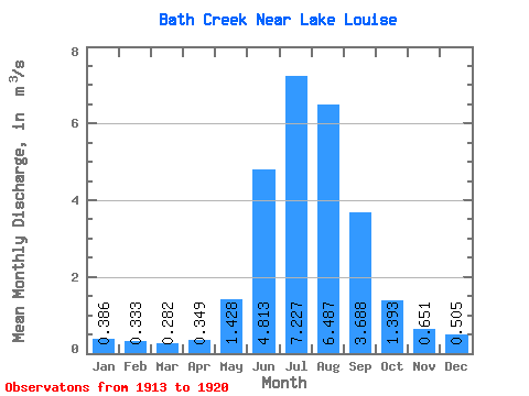
| Statistic | Jan | Feb | Mar | Apr | May | Jun | Jul | Aug | Sep | Oct | Nov | Dec | Annual |
|---|---|---|---|---|---|---|---|---|---|---|---|---|---|
| Mean | 0.39 | 0.33 | 0.28 | 0.35 | 1.43 | 4.81 | 7.23 | 6.49 | 3.69 | 1.39 | 0.65 | 0.51 | 2.51 |
| Standard Deviation | 0.05 | 0.05 | 0.03 | 0.09 | 0.50 | 2.17 | 1.53 | 1.58 | 1.32 | 0.49 | 0.09 | 0.09 | 0.48 |
| Min | 0.30 | 0.27 | 0.25 | 0.26 | 0.92 | 2.96 | 4.70 | 4.29 | 2.54 | 1.00 | 0.56 | 0.36 | 2.17 |
| Max | 0.45 | 0.41 | 0.32 | 0.43 | 2.06 | 8.97 | 9.30 | 9.16 | 6.20 | 2.29 | 0.80 | 0.61 | 3.05 |
| Coefficient of Variation | 0.14 | 0.16 | 0.12 | 0.25 | 0.35 | 0.45 | 0.21 | 0.24 | 0.36 | 0.35 | 0.14 | 0.18 | 0.19 |
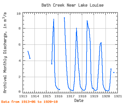
| Year | Jan | Feb | Mar | Apr | May | Jun | Jul | Aug | Sep | Oct | Nov | Dec | Annual | 1913 | 5.17 | 4.70 | 4.29 | 1915 | 3.61 | 6.70 | 9.16 | 2.78 | 1.00 | 0.67 | 0.51 | 1916 | 0.45 | 0.41 | 9.30 | 5.84 | 3.50 | 1.31 | 0.65 | 0.48 | 1917 | 0.38 | 0.33 | 0.26 | 0.26 | 1.57 | 3.85 | 8.03 | 6.07 | 3.21 | 2.29 | 0.80 | 0.56 | 2.30 | 1918 | 0.42 | 0.35 | 0.32 | 0.43 | 1.16 | 8.97 | 8.14 | 7.89 | 6.20 | 1.57 | 0.56 | 0.61 | 3.05 | 1919 | 0.38 | 0.31 | 0.30 | 0.41 | 2.06 | 4.32 | 6.05 | 6.27 | 3.90 | 1.04 | 0.58 | 0.36 | 2.17 | 1920 | 0.30 | 0.27 | 0.25 | 0.29 | 0.92 | 2.96 | 7.67 | 5.89 | 2.54 | 1.15 |
|---|
 Return to R-Arctic Net Home Page