|
|
|||||||||||||||||
| Point ID: 177 | Downloads | Plots | Site Data | Other Close Sites | Code: 05AG006 |
|
|
|||||||||||||||||
| Download | |
|---|---|
| Site Descriptor Information | Site Time Series Data |
| Link to all available data | |
|
|
| View: | Statistics | Time Series |
| Units: | mm |
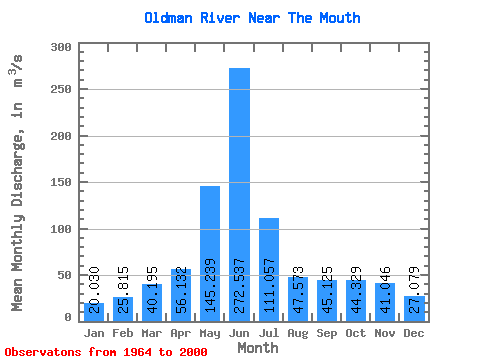
| Statistic | Jan | Feb | Mar | Apr | May | Jun | Jul | Aug | Sep | Oct | Nov | Dec | Annual |
|---|---|---|---|---|---|---|---|---|---|---|---|---|---|
| Mean | 20.03 | 25.82 | 40.20 | 56.13 | 145.24 | 272.54 | 111.06 | 47.57 | 45.12 | 44.33 | 41.05 | 27.08 | 72.12 |
| Standard Deviation | 7.69 | 14.35 | 23.58 | 39.12 | 94.86 | 213.12 | 96.64 | 41.07 | 36.26 | 26.62 | 24.95 | 18.95 | 37.12 |
| Min | 7.62 | 8.32 | 16.20 | 15.00 | 22.30 | 24.00 | 8.76 | 9.12 | 9.79 | 16.40 | 17.00 | 10.20 | 20.55 |
| Max | 42.60 | 66.60 | 100.00 | 169.00 | 444.00 | 777.00 | 369.00 | 200.00 | 176.00 | 110.00 | 103.00 | 79.80 | 139.68 |
| Coefficient of Variation | 0.38 | 0.56 | 0.59 | 0.70 | 0.65 | 0.78 | 0.87 | 0.86 | 0.80 | 0.60 | 0.61 | 0.70 | 0.52 |
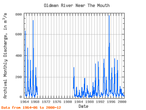
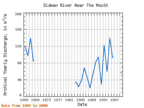
| Year | Jan | Feb | Mar | Apr | May | Jun | Jul | Aug | Sep | Oct | Nov | Dec | Annual | 1964 | 633.00 | 167.00 | 30.20 | 22.50 | 32.50 | 23.60 | 15.20 | 1965 | 20.90 | 31.30 | 32.00 | 97.40 | 210.00 | 471.00 | 248.00 | 63.60 | 72.20 | 101.00 | 46.30 | 39.30 | 119.42 | 1966 | 25.60 | 21.20 | 51.20 | 117.00 | 249.00 | 358.00 | 160.00 | 54.40 | 48.40 | 28.20 | 38.30 | 18.60 | 97.49 | 1967 | 15.50 | 22.80 | 57.80 | 83.30 | 444.00 | 731.00 | 207.00 | 40.00 | 18.90 | 17.40 | 28.30 | 10.20 | 139.68 | 1968 | 15.40 | 18.60 | 37.30 | 30.80 | 140.00 | 288.00 | 95.60 | 56.00 | 111.00 | 110.00 | 87.10 | 38.60 | 85.70 | 1982 | 96.20 | 288.00 | 126.00 | 23.50 | 17.10 | 37.70 | 28.00 | 18.10 | 1983 | 17.70 | 19.40 | 26.40 | 26.00 | 95.10 | 106.00 | 36.30 | 15.50 | 12.10 | 16.40 | 23.80 | 12.70 | 33.95 | 1984 | 18.00 | 26.30 | 18.70 | 15.00 | 29.00 | 76.50 | 28.00 | 10.60 | 9.79 | 17.80 | 21.80 | 10.80 | 23.52 | 1985 | 8.04 | 8.32 | 16.20 | 21.80 | 102.00 | 98.20 | 8.76 | 9.12 | 32.90 | 55.40 | 68.20 | 38.00 | 38.91 | 1986 | 30.50 | 66.60 | 100.00 | 85.60 | 183.00 | 187.00 | 17.40 | 9.14 | 19.70 | 52.40 | 34.30 | 28.60 | 67.85 | 1987 | 22.60 | 26.60 | 35.60 | 67.40 | 119.00 | 46.70 | 44.50 | 40.70 | 66.00 | 35.80 | 17.00 | 10.80 | 44.39 | 1988 | 7.62 | 12.50 | 16.20 | 17.90 | 42.40 | 54.90 | 13.20 | 13.10 | 13.30 | 23.50 | 18.70 | 13.30 | 20.55 | 1989 | 11.60 | 10.30 | 19.50 | 42.50 | 82.20 | 147.00 | 20.60 | 18.70 | 61.80 | 40.20 | 103.00 | 49.30 | 50.56 | 1990 | 26.40 | 23.80 | 47.90 | 96.20 | 237.00 | 322.00 | 60.10 | 40.00 | 21.90 | 32.30 | 53.00 | 22.60 | 81.93 | 1991 | 20.00 | 35.90 | 36.50 | 54.00 | 183.00 | 342.00 | 241.00 | 108.00 | 41.10 | 24.20 | 24.80 | 19.10 | 94.13 | 1992 | 18.70 | 18.40 | 19.60 | 16.10 | 22.30 | 24.00 | 55.80 | 37.50 | 36.50 | 41.10 | 39.10 | 19.10 | 29.02 | 1993 | 18.70 | 19.80 | 47.60 | 41.50 | 111.00 | 291.00 | 369.00 | 200.00 | 176.00 | 107.00 | 44.90 | 38.90 | 122.12 | 1994 | 27.40 | 23.60 | 67.10 | 66.20 | 200.00 | 135.00 | 38.20 | 37.90 | 34.60 | 38.80 | 21.20 | 16.70 | 58.89 | 1995 | 16.00 | 20.20 | 24.00 | 27.60 | 187.00 | 777.00 | 259.00 | 89.40 | 59.40 | 62.80 | 76.60 | 75.70 | 139.56 | 1996 | 42.60 | 61.70 | 80.10 | 169.00 | 188.00 | 286.00 | 106.00 | 42.80 | 46.70 | 51.00 | 24.80 | 20.90 | 93.30 | 1997 | 22.50 | 39.00 | 78.00 | 64.20 | 212.00 | 371.00 | 80.60 | 48.10 | 47.40 | 32.50 | 28.90 | 19.40 | 86.97 | 1998 | 14.50 | 21.00 | 21.60 | 31.00 | 109.00 | 356.00 | 163.00 | 44.70 | 38.10 | 40.40 | 27.20 | 20.50 | 73.92 | 1999 | 17.60 | 20.50 | 24.60 | 31.60 | 52.00 | 110.00 | 90.70 | 77.30 | 43.90 | 39.20 | 86.10 | 79.80 | 56.11 | 2000 | 22.80 | 20.10 | 26.40 | 32.80 | 47.30 | 41.60 | 29.60 | 31.50 | 31.70 | 26.30 | 20.10 | 13.70 | 28.66 |
|---|
| Other Close Sites | ||||||
|---|---|---|---|---|---|---|
| PointID | Latitude | Longitude | Drainage Area | Source | Name | |
| 351 | "BOW RIVER NEAR THE MOUTH" | 50.04 | 1602106 | Hydat | ||
 Return to R-Arctic Net Home Page