|
|
|||||||||||||||||
| Point ID: 107 | Downloads | Plots | Site Data | Code: 05AD031 |
|
|
|||||||||||||||||
| Download | |
|---|---|
| Site Descriptor Information | Site Time Series Data |
| Link to all available data | |
|
|
| View: | Statistics | Time Series |
| Units: | mm |
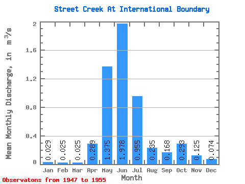
| Statistic | Jan | Feb | Mar | Apr | May | Jun | Jul | Aug | Sep | Oct | Nov | Dec | Annual |
|---|---|---|---|---|---|---|---|---|---|---|---|---|---|
| Mean | 0.03 | 0.03 | 0.03 | 0.29 | 1.38 | 1.98 | 0.95 | 0.23 | 0.17 | 0.29 | 0.12 | 0.07 | 0.47 |
| Standard Deviation | 0.01 | 0.02 | 0.02 | 0.19 | 0.34 | 0.79 | 0.46 | 0.09 | 0.19 | 0.26 | 0.09 | 0.05 | 0.12 |
| Min | 0.01 | 0.01 | 0.01 | 0.09 | 0.70 | 0.99 | 0.27 | 0.07 | 0.04 | 0.02 | 0.01 | 0.01 | 0.34 |
| Max | 0.04 | 0.06 | 0.05 | 0.53 | 1.67 | 3.29 | 1.58 | 0.35 | 0.60 | 0.75 | 0.24 | 0.12 | 0.58 |
| Coefficient of Variation | 0.43 | 0.75 | 0.64 | 0.67 | 0.25 | 0.40 | 0.49 | 0.38 | 1.11 | 0.88 | 0.74 | 0.67 | 0.25 |
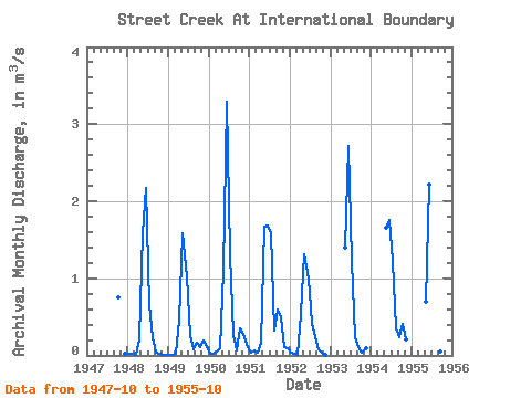
| Year | Jan | Feb | Mar | Apr | May | Jun | Jul | Aug | Sep | Oct | Nov | Dec | Annual | 1947 | 0.75 | 0.03 | 1948 | 0.02 | 0.02 | 0.01 | 0.20 | 1.59 | 2.17 | 0.65 | 0.24 | 0.04 | 0.02 | 0.01 | 0.01 | 0.42 | 1949 | 0.01 | 0.01 | 0.01 | 0.46 | 1.58 | 1.02 | 0.27 | 0.07 | 0.17 | 0.11 | 0.20 | 0.12 | 0.34 | 1950 | 0.03 | 0.02 | 0.05 | 0.09 | 1.09 | 3.29 | 1.31 | 0.26 | 0.07 | 0.35 | 0.24 | 0.11 | 0.58 | 1951 | 0.04 | 0.06 | 0.04 | 0.16 | 1.67 | 1.68 | 1.58 | 0.33 | 0.60 | 0.49 | 0.11 | 0.09 | 0.57 | 1952 | 0.04 | 0.02 | 0.01 | 0.53 | 1.31 | 0.99 | 0.42 | 0.23 | 0.07 | 0.03 | 0.01 | 1953 | 1.40 | 2.71 | 1.22 | 0.23 | 0.10 | 0.03 | 0.09 | 1954 | 1.66 | 1.75 | 1.23 | 0.35 | 0.23 | 0.41 | 0.20 | 1955 | 0.70 | 2.21 | 0.96 | 0.15 | 0.06 | 0.43 |
|---|
 Return to R-Arctic Net Home Page