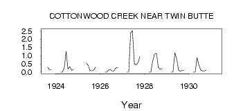
| PointID: | 91 | Code: | 05AD012 | Latitude (decimal degrees): | 49.13 | Longitude (decimal degrees): | -113.85 | Drainage Area (km2): | 34.20 | Source: | Hydat | Hydrological Zone: | Nelson | Name: | COTTONWOOD CREEK NEAR TWIN BUTTE |
|---|
| Download | |
|---|---|
| Site Descriptor Information | Site Time Series Data |
| Link to all available data | |
| ID | Year | Jan | Feb | Mar | Apr | May | Jun | Jul | Aug | Sep | Oct | Nov | Dec |
|---|---|---|---|---|---|---|---|---|---|---|---|---|---|
| 91 | 1923 | 0.29 | 0.15 | 0.15 | |||||||||
| 91 | 1924 | 0.00 | 0.00 | 0.26 | 1.26 | 0.19 | 0.33 | 0.11 | 0.15 | ||||
| 91 | 1925 | 0.54 | 0.42 | 0.09 | 0.08 | 0.13 | 0.30 | ||||||
| 91 | 1926 | 0.00 | 0.00 | 0.12 | 0.16 | 0.07 | 0.07 | 0.26 | 0.25 | ||||
| 91 | 1927 | 0.00 | 0.00 | 2.35 | 2.52 | 0.49 | 0.46 | 0.57 | 0.95 | ||||
| 91 | 1928 | 0.00 | 0.00 | 0.67 | 1.08 | 1.14 | 0.29 | 0.17 | 0.22 | ||||
| 91 | 1929 | 0.00 | 0.00 | 1.18 | 0.79 | 0.11 | 0.06 | 0.10 | 0.10 | ||||
| 91 | 1930 | 0.00 | 0.00 | 0.88 | 0.44 | 0.13 | 0.07 | 0.07 | 0.12 | ||||
| 91 | 1931 | 0.00 |
 Return to R-Arctic Net Home Page