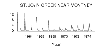
| PointID: | 892 | Code: | 07FC002 | Latitude (decimal degrees): | 56.42 | Longitude (decimal degrees): | -120.92 | Drainage Area (km2): | 201.00 | Source: | Hydat | Hydrological Zone: | Mackenzie | Name: | ST. JOHN CREEK NEAR MONTNEY |
|---|
| Download | |
|---|---|
| Site Descriptor Information | Site Time Series Data |
| Link to all available data | |
| ID | Year | Jan | Feb | Mar | Apr | May | Jun | Jul | Aug | Sep | Oct | Nov | Dec |
|---|---|---|---|---|---|---|---|---|---|---|---|---|---|
| 892 | 1962 | 1.71 | 0.34 | 0.14 | 0.14 | 0.00 | 0.00 | ||||||
| 892 | 1963 | 0.00 | 0.00 | 0.00 | 13.00 | 4.04 | 0.16 | 0.11 | 0.22 | 0.04 | 5.0e-03 | 0.00 | 0.00 |
| 892 | 1964 | 4.25 | 0.37 | 0.08 | 0.63 | 0.10 | |||||||
| 892 | 1965 | 10.00 | 2.22 | 0.98 | 0.28 | 8.0e-03 | 0.00 | 3.0e-03 | |||||
| 892 | 1966 | 2.00 | 0.22 | 0.02 | 0.15 | 0.01 | 0.03 | 7.0e-03 | 0.00 | 0.00 | |||
| 892 | 1967 | 0.00 | 0.00 | 0.00 | 0.00 | 7.96 | 0.26 | 0.01 | 0.00 | 0.00 | 0.00 | 0.00 | 0.00 |
| 892 | 1968 | 0.00 | 0.00 | 0.00 | 1.00 | 0.22 | 0.14 | 0.03 | 0.01 | 4.0e-03 | 0.01 | 0.00 | 0.00 |
| 892 | 1969 | 0.00 | 0.00 | 0.00 | 3.00 | 1.30 | 0.10 | 0.21 | 1.0e-03 | 0.80 | 0.15 | 0.00 | 0.00 |
| 892 | 1970 | 0.00 | 0.00 | 0.00 | 2.00 | 0.98 | 0.36 | 0.35 | 0.05 | 2.0e-03 | 5.0e-03 | 0.00 | 0.00 |
| 892 | 1971 | 0.00 | 0.00 | 0.00 | 4.00 | 0.62 | 2.37 | 1.89 | 0.04 | 0.03 | 0.05 | 0.00 | 0.00 |
| 892 | 1972 | 0.00 | 0.00 | 1.00 | 3.00 | 3.99 | 0.15 | 1.23 | 1.04 | 0.19 | 0.40 | 0.00 | 0.00 |
| 892 | 1973 | 0.00 | 0.00 | 0.00 | 5.00 | 0.97 | 0.31 | 0.05 | 7.0e-03 | 0.02 | 0.03 | 0.00 | 0.00 |
| 892 | 1974 | 0.00 | 0.00 | 0.00 | 7.00 | 2.75 | 0.05 | 0.63 | 0.03 | 0.12 | 0.07 |
 Return to R-Arctic Net Home Page