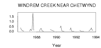
| PointID: | 890 | Code: | 07FB011 | Latitude (decimal degrees): | 55.69 | Longitude (decimal degrees): | -121.63 | Drainage Area (km2): | 22.88 | Source: | Hydat | Hydrological Zone: | Mackenzie | Name: | WINDREM CREEK NEAR CHETWYND |
|---|
| Download | |
|---|---|
| Site Descriptor Information | Site Time Series Data |
| Link to all available data | |
| ID | Year | Jan | Feb | Mar | Apr | May | Jun | Jul | Aug | Sep | Oct | Nov | Dec |
|---|---|---|---|---|---|---|---|---|---|---|---|---|---|
| 890 | 1986 | 0.35 | 0.13 | 0.10 | 0.01 | 0.03 | |||||||
| 890 | 1987 | 0.00 | 0.21 | 0.07 | 0.19 | 1.82 | 0.09 | ||||||
| 890 | 1988 | 0.00 | 0.22 | 0.29 | 0.07 | 0.01 | 0.00 | ||||||
| 890 | 1989 | 0.16 | 0.13 | 0.10 | 0.07 | 0.02 | 0.02 | ||||||
| 890 | 1990 | 0.35 | 0.53 | 0.05 | 0.01 | 1.0e-03 | 5.0e-03 | ||||||
| 890 | 1991 | 0.11 | 0.34 | 0.02 | 0.00 | 4.0e-03 | 1.0e-03 | ||||||
| 890 | 1992 | 0.10 | 0.01 | 0.00 | 0.00 | 0.00 | 0.00 | ||||||
| 890 | 1993 | 0.00 | 0.11 | 0.14 | 0.34 | 0.10 | 0.12 |
 Return to R-Arctic Net Home Page