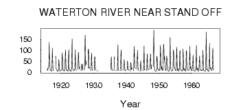
| PointID: | 89 | Code: | 05AD008 | Latitude (decimal degrees): | 49.50 | Longitude (decimal degrees): | -113.32 | Drainage Area (km2): | 1730.00 | Source: | Hydat | Hydrological Zone: | Nelson | Name: | WATERTON RIVER NEAR STAND OFF |
|---|
| Download | |
|---|---|
| Site Descriptor Information | Site Time Series Data |
| Link to all available data | |
| ID | Year | Jan | Feb | Mar | Apr | May | Jun | Jul | Aug | Sep | Oct | Nov | Dec |
|---|---|---|---|---|---|---|---|---|---|---|---|---|---|
| 89 | 1915 | 14.00 | 8.00 | ||||||||||
| 89 | 1916 | 5.00 | 19.00 | 18.00 | 22.00 | 48.40 | 137.00 | 83.20 | 22.10 | 18.30 | 8.76 | 9.00 | 6.00 |
| 89 | 1917 | 4.00 | 3.00 | 3.00 | 11.00 | 68.90 | 110.00 | 55.20 | 12.70 | 6.46 | 4.91 | ||
| 89 | 1918 | 72.40 | 20.70 | 11.70 | 11.90 | 8.89 | 5.00 | 3.00 | |||||
| 89 | 1919 | 2.00 | 4.00 | 3.00 | 11.00 | 56.00 | 50.80 | 21.30 | 8.68 | 4.63 | 3.52 | 4.00 | 4.00 |
| 89 | 1920 | 5.00 | 5.00 | 6.00 | 13.00 | 54.10 | 87.10 | 54.00 | 13.20 | 8.19 | 10.70 | 6.00 | 5.00 |
| 89 | 1921 | 3.00 | 5.00 | 8.00 | 22.00 | 72.10 | 102.00 | 41.20 | 12.50 | 7.76 | 9.62 | 7.00 | 5.00 |
| 89 | 1922 | 4.00 | 3.00 | 3.00 | 12.00 | 71.50 | 103.00 | 32.30 | 10.50 | 6.22 | 5.40 | 7.00 | 3.00 |
| 89 | 1923 | 4.00 | 3.00 | 4.00 | 13.00 | 68.90 | 151.00 | 36.20 | 18.20 | 10.80 | 9.76 | 7.00 | 5.00 |
| 89 | 1924 | 4.00 | 5.00 | 6.00 | 11.00 | 62.20 | 102.00 | 34.40 | 20.40 | 7.81 | 6.56 | ||
| 89 | 1925 | 11.00 | 36.00 | 89.50 | 89.20 | 34.60 | 13.00 | 15.50 | 21.80 | ||||
| 89 | 1926 | 5.00 | 24.00 | 36.60 | 29.20 | 16.40 | 6.70 | 26.70 | 34.50 | ||||
| 89 | 1927 | 7.00 | 23.00 | 97.60 | 170.00 | 82.70 | 27.60 | 50.10 | 34.50 | ||||
| 89 | 1928 | 18.00 | 99.60 | 105.00 | 77.10 | 19.60 | 13.20 | 22.30 | |||||
| 89 | 1929 | 4.00 | 13.00 | 68.60 | 86.40 | 29.90 | 8.95 | 5.94 | 7.70 | ||||
| 89 | 1930 | 6.00 | 36.00 | 68.80 | 69.10 | 26.80 | 10.10 | 7.77 | 7.55 | ||||
| 89 | 1931 | 3.00 | 6.00 | ||||||||||
| 89 | 1935 | 11.00 | 46.70 | 68.90 | 32.20 | 10.80 | 6.40 | 5.11 | |||||
| 89 | 1936 | 6.00 | 17.00 | 70.80 | 56.10 | 6.08 | 5.36 | 5.11 | |||||
| 89 | 1937 | 4.00 | 7.00 | 52.20 | 125.00 | 25.20 | 9.61 | 5.41 | 6.47 | ||||
| 89 | 1938 | 4.00 | 19.00 | 80.70 | 101.00 | 34.40 | 10.60 | 6.50 | 5.46 | ||||
| 89 | 1939 | 8.00 | 14.00 | 55.80 | 46.60 | 19.70 | 6.24 | 4.36 | 7.29 | ||||
| 89 | 1940 | 8.00 | 12.00 | 50.70 | 44.70 | 17.20 | 8.36 | 7.72 | 10.70 | ||||
| 89 | 1941 | 3.00 | 11.00 | 42.70 | 39.90 | 22.90 | 7.92 | 12.50 | 19.00 | ||||
| 89 | 1942 | 4.00 | 21.00 | 71.70 | 118.00 | 54.80 | 22.70 | 19.10 | 14.60 | ||||
| 89 | 1943 | 10.00 | 47.00 | 64.60 | 99.50 | 64.40 | 16.30 | 7.43 | 4.73 | ||||
| 89 | 1944 | 2.00 | 5.00 | 35.50 | 50.70 | 19.50 | 8.78 | 6.12 | 5.97 | ||||
| 89 | 1945 | 5.00 | 5.00 | 62.30 | 120.00 | 32.20 | 8.41 | 8.05 | 9.96 | ||||
| 89 | 1946 | 5.00 | 17.00 | 72.40 | 83.80 | 30.70 | 9.12 | 10.70 | 13.00 | ||||
| 89 | 1947 | 11.00 | 24.00 | 81.70 | 78.70 | 35.80 | 12.00 | 15.80 | 30.90 | ||||
| 89 | 1948 | 24.00 | 109.00 | 192.00 | 40.40 | 22.50 | 7.59 | 5.54 | 4.00 | 3.00 | |||
| 89 | 1949 | 2.00 | 2.00 | 4.00 | 12.00 | 72.10 | 66.50 | 29.60 | 16.10 | 10.60 | 8.95 | 9.00 | 11.00 |
| 89 | 1950 | 5.00 | 6.00 | 7.00 | 21.00 | 58.20 | 123.00 | 70.70 | 20.40 | 8.33 | 16.20 | 26.00 | 13.00 |
| 89 | 1951 | 8.00 | 6.00 | 9.00 | 37.00 | 117.00 | 128.00 | 114.00 | 51.90 | 71.90 | 57.20 | 17.00 | 9.00 |
| 89 | 1952 | 5.00 | 7.00 | 10.00 | 42.00 | 73.20 | 60.10 | 36.70 | 23.00 | 9.23 | 5.27 | 2.00 | 2.00 |
| 89 | 1953 | 3.00 | 4.00 | 7.00 | 21.00 | 79.60 | 158.00 | 61.50 | 18.70 | 8.24 | 4.84 | 5.00 | 4.00 |
| 89 | 1954 | 3.00 | 6.00 | 5.00 | 15.00 | 90.30 | 101.00 | 88.60 | 21.50 | 19.60 | 20.60 | 13.00 | 10.00 |
| 89 | 1955 | 7.00 | 4.00 | 4.00 | 19.00 | 56.80 | 115.00 | 59.50 | 14.60 | 5.87 | 16.20 | 15.00 | 5.00 |
| 89 | 1956 | 4.00 | 3.00 | 10.00 | 22.00 | 87.70 | 99.80 | 53.40 | 14.80 | 7.08 | 7.35 | 5.00 | 5.00 |
| 89 | 1957 | 3.00 | 3.00 | 8.00 | 8.00 | 106.00 | 80.70 | 20.20 | 8.42 | 6.79 | 11.00 | 15.00 | 7.00 |
| 89 | 1958 | 5.00 | 2.00 | 8.00 | 24.00 | 98.10 | 89.10 | 29.20 | 10.50 | 7.17 | 8.54 | 7.00 | 7.00 |
| 89 | 1959 | 8.00 | 6.00 | 9.00 | 23.00 | 69.00 | 118.00 | 52.50 | 13.60 | 18.30 | 24.90 | 14.00 | 7.00 |
| 89 | 1960 | 4.00 | 4.00 | 13.00 | 21.00 | 51.70 | 78.30 | 36.40 | 13.70 | 5.81 | 3.62 | 3.00 | 3.00 |
| 89 | 1961 | 3.00 | 4.00 | 5.00 | 9.00 | 81.30 | 122.00 | 26.20 | 8.55 | 7.90 | 17.10 | 12.00 | 5.00 |
| 89 | 1962 | 3.00 | 6.00 | 7.00 | 28.00 | 49.00 | 73.50 | 26.70 | 10.80 | 7.64 | 8.41 | 9.00 | 6.00 |
| 89 | 1963 | 5.00 | 8.00 | 5.00 | 8.00 | 47.70 | 98.50 | 46.00 | 9.91 | 5.74 | 4.91 | 4.00 | 4.00 |
| 89 | 1964 | 3.00 | 2.00 | 3.00 | 6.00 | 74.30 | 184.00 | 55.40 | 10.10 | 8.93 | 13.80 | 7.00 | 4.00 |
| 89 | 1965 | 4.00 | 3.00 | 1.00 | 13.00 | 17.50 | 133.00 | 62.30 | 18.10 | 13.20 | 17.70 | 19.00 | 9.00 |
| 89 | 1966 | 6.00 | 6.00 | 7.00 | 11.00 | 60.50 | 110.00 | 47.20 | 15.50 | 10.00 |
 Return to R-Arctic Net Home Page