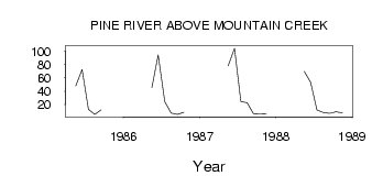
| PointID: | 889 | Code: | 07FB010 | Latitude (decimal degrees): | 55.50 | Longitude (decimal degrees): | -122.57 | Drainage Area (km2): | 677.00 | Source: | Hydat | Hydrological Zone: | Mackenzie | Name: | PINE RIVER ABOVE MOUNTAIN CREEK |
|---|
| Download | |
|---|---|
| Site Descriptor Information | Site Time Series Data |
| Link to all available data | |
| ID | Year | Jan | Feb | Mar | Apr | May | Jun | Jul | Aug | Sep | Oct | Nov | Dec |
|---|---|---|---|---|---|---|---|---|---|---|---|---|---|
| 889 | 1985 | 47.60 | 72.20 | 12.60 | 4.98 | 12.00 | |||||||
| 889 | 1986 | 45.00 | 94.00 | 23.90 | 7.00 | 5.27 | 8.43 | ||||||
| 889 | 1987 | 77.70 | 104.00 | 24.40 | 22.60 | 6.00 | 5.49 | 6.00 | |||||
| 889 | 1988 | 69.40 | 53.20 | 11.90 | 7.96 | 6.61 | 8.94 | 7.00 |
 Return to R-Arctic Net Home Page