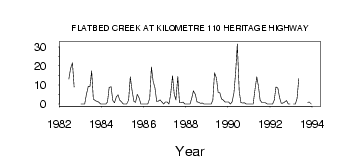
| PointID: | 888 | Code: | 07FB009 | Latitude (decimal degrees): | 55.08 | Longitude (decimal degrees): | -120.94 | Drainage Area (km2): | 697.00 | Source: | Hydat | Hydrological Zone: | Mackenzie | Name: | FLATBED CREEK AT KILOMETRE 110 HERITAGE HIGHWAY |
|---|
| Download | |
|---|---|
| Site Descriptor Information | Site Time Series Data |
| Link to all available data | |
| ID | Year | Jan | Feb | Mar | Apr | May | Jun | Jul | Aug | Sep | Oct | Nov | Dec |
|---|---|---|---|---|---|---|---|---|---|---|---|---|---|
| 888 | 1982 | 13.10 | 18.50 | 21.70 | 8.94 | ||||||||
| 888 | 1983 | 0.00 | 0.00 | 0.00 | 5.00 | 9.39 | 9.27 | 17.40 | 2.73 | 1.74 | 1.46 | 1.00 | 0.00 |
| 888 | 1984 | 0.00 | 0.00 | 0.00 | 1.00 | 8.68 | 9.13 | 1.93 | 0.63 | 3.82 | 4.79 | 2.00 | 1.00 |
| 888 | 1985 | 0.00 | 0.00 | 0.00 | 2.00 | 14.30 | 7.47 | 1.47 | 0.97 | 5.08 | 3.19 | 0.00 | 0.00 |
| 888 | 1986 | 0.00 | 0.00 | 0.00 | 3.00 | 19.40 | 12.10 | 8.32 | 1.42 | 1.52 | 2.20 | 1.00 | 0.00 |
| 888 | 1987 | 1.00 | 1.00 | 0.00 | 5.00 | 14.90 | 5.38 | 2.15 | 14.40 | 0.72 | 0.66 | 1.00 | 0.00 |
| 888 | 1988 | 0.00 | 0.00 | 0.00 | 3.00 | 6.98 | 5.01 | 1.12 | 0.95 | 0.42 | 0.55 | 0.00 | 0.00 |
| 888 | 1989 | 0.00 | 0.00 | 0.00 | 2.00 | 16.40 | 13.60 | 6.20 | 5.93 | 2.71 | 2.10 | 1.00 | 1.00 |
| 888 | 1990 | 1.00 | 0.00 | 1.00 | 6.00 | 16.60 | 31.50 | 6.43 | 0.82 | 0.51 | 0.70 | 0.00 | 0.00 |
| 888 | 1991 | 0.00 | 0.00 | 0.00 | 8.00 | 14.20 | 9.33 | 2.03 | 0.66 | 0.73 | 0.67 | 0.00 | 0.00 |
| 888 | 1992 | 0.00 | 0.00 | 2.00 | 9.00 | 8.31 | 3.38 | 0.38 | 0.50 | 1.18 | 1.75 | 0.00 | 0.00 |
| 888 | 1993 | 0.00 | 0.00 | 3.00 | 13.30 | 0.90 | 1.00 | 0.00 |
 Return to R-Arctic Net Home Page