| PointID: | 886 | Code: | 07FB007 | Latitude (decimal degrees): | 55.18 | Longitude (decimal degrees): | -121.76 | Drainage Area (km2): | 927.00 | Source: | Hydat | Hydrological Zone: | Mackenzie | Name: | SUKUNKA RIVER ABOVE CHAMBERLAIN CREEK |
|---|
| Download | |
|---|---|
| Site Descriptor Information | Site Time Series Data |
| Link to all available data | |
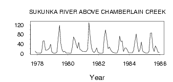
| ID | Year | Jan | Feb | Mar | Apr | May | Jun | Jul | Aug | Sep | Oct | Nov | Dec |
|---|---|---|---|---|---|---|---|---|---|---|---|---|---|
| 886 | 1977 | 10.00 | 3.00 | ||||||||||
| 886 | 1978 | 2.00 | 2.00 | 1.00 | 6.00 | 52.60 | 53.10 | 14.70 | 14.00 | 17.30 | 22.70 | 39.00 | 7.00 |
| 886 | 1979 | 2.00 | 1.00 | 2.00 | 7.00 | 65.60 | 118.00 | 42.70 | 14.50 | 6.90 | 9.74 | 3.00 | 2.00 |
| 886 | 1980 | 2.00 | 1.00 | 1.00 | 27.00 | 69.40 | 58.20 | 38.10 | 22.30 | 46.40 | 17.00 | 14.00 | 9.00 |
| 886 | 1981 | 9.00 | 8.00 | 9.00 | 19.00 | 130.00 | 66.60 | 25.50 | 9.35 | 4.42 | 10.10 | 24.00 | 6.00 |
| 886 | 1982 | 2.00 | 1.00 | 1.00 | 3.00 | 68.60 | 98.90 | 60.10 | 20.50 | 27.40 | 15.60 | 8.00 | 4.00 |
| 886 | 1983 | 3.00 | 2.00 | 2.00 | 18.00 | 73.00 | 51.00 | 52.40 | 9.08 | 22.60 | 23.10 | 16.00 | 3.00 |
| 886 | 1984 | 3.00 | 3.00 | 3.00 | 14.00 | 52.40 | 81.90 | 32.50 | 7.46 | 16.80 | 48.40 | 11.00 | 6.00 |
| 886 | 1985 | 3.00 | 2.00 | 2.00 | 9.00 | 84.90 | 86.40 | 24.40 | 8.19 | 32.00 | 21.60 | 6.00 | 4.00 |
 Return to R-Arctic Net Home Page