| PointID: | 876 | Code: | 07FA003 | Latitude (decimal degrees): | 56.50 | Longitude (decimal degrees): | -122.24 | Drainage Area (km2): | 3780.00 | Source: | Hydat | Hydrological Zone: | Mackenzie | Name: | HALFWAY RIVER ABOVE GRAHAM RIVER |
|---|
| Download | |
|---|---|
| Site Descriptor Information | Site Time Series Data |
| Link to all available data | |
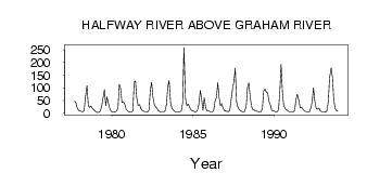
| ID | Year | Jan | Feb | Mar | Apr | May | Jun | Jul | Aug | Sep | Oct | Nov | Dec |
|---|---|---|---|---|---|---|---|---|---|---|---|---|---|
| 876 | 1977 | 47.60 | 38.20 | 19.00 | 10.00 | ||||||||
| 876 | 1978 | 7.00 | 6.00 | 5.00 | 11.00 | 62.60 | 108.00 | 30.20 | 21.40 | 27.90 | 18.50 | 14.00 | 7.00 |
| 876 | 1979 | 3.00 | 2.00 | 3.00 | 7.00 | 30.00 | 61.80 | 92.20 | 29.40 | 63.80 | 35.20 | 16.00 | 6.00 |
| 876 | 1980 | 4.00 | 3.00 | 4.00 | 8.00 | 19.30 | 113.00 | 96.90 | 42.50 | 45.70 | 35.40 | 15.00 | 9.00 |
| 876 | 1981 | 5.00 | 3.00 | 3.00 | 8.00 | 121.00 | 126.00 | 60.20 | 29.50 | 32.60 | 17.90 | 11.00 | 7.00 |
| 876 | 1982 | 5.00 | 5.00 | 4.00 | 12.00 | 92.10 | 121.00 | 63.70 | 30.80 | 22.60 | 17.20 | 9.00 | 6.00 |
| 876 | 1983 | 4.00 | 4.00 | 4.00 | 9.00 | 33.10 | 103.00 | 128.00 | 38.60 | 19.10 | 12.40 | 6.00 | 4.00 |
| 876 | 1984 | 3.00 | 4.00 | 5.00 | 8.00 | 39.30 | 259.00 | 56.60 | 28.60 | 35.00 | 25.70 | 14.00 | 10.00 |
| 876 | 1985 | 7.00 | 4.00 | 4.00 | 11.00 | 33.60 | 89.40 | 51.10 | 11.20 | 59.80 | 23.80 | 9.00 | 8.00 |
| 876 | 1986 | 6.00 | 4.00 | 4.00 | 8.00 | 45.00 | 63.30 | 120.00 | 61.80 | 29.20 | 37.50 | 17.00 | 10.00 |
| 876 | 1987 | 7.00 | 6.00 | 5.00 | 12.00 | 58.80 | 98.00 | 125.00 | 178.00 | 43.60 | 23.10 | 13.00 | 8.00 |
| 876 | 1988 | 5.00 | 5.00 | 5.00 | 28.00 | 101.00 | 119.00 | 66.50 | 27.60 | 13.30 | 11.20 | 7.00 | 7.00 |
| 876 | 1989 | 5.00 | 4.00 | 4.00 | 16.00 | 86.50 | 95.10 | 83.80 | 78.90 | 44.80 | 31.80 | 9.00 | 9.00 |
| 876 | 1990 | 7.00 | 4.00 | 5.00 | 13.00 | 87.50 | 192.00 | 84.10 | 28.70 | 16.40 | 12.10 | 8.00 | 5.00 |
| 876 | 1991 | 4.00 | 4.00 | 4.00 | 11.00 | 52.80 | 74.60 | 55.20 | 21.30 | 23.20 | 16.90 | 10.00 | 6.00 |
| 876 | 1992 | 4.00 | 4.00 | 5.00 | 21.00 | 44.40 | 99.80 | 42.60 | 17.10 | 15.30 | 19.90 | 9.00 | 5.00 |
| 876 | 1993 | 4.00 | 4.00 | 3.00 | 9.00 | 44.40 | 140.00 | 179.00 | 142.00 | 51.60 | 19.60 | 10.00 | 8.00 |
 Return to R-Arctic Net Home Page