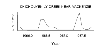
| PointID: | 868 | Code: | 07EE004 | Latitude (decimal degrees): | 55.31 | Longitude (decimal degrees): | -123.09 | Drainage Area (km2): | 72.30 | Source: | Hydat | Hydrological Zone: | Mackenzie | Name: | CHICHOUYENILY CREEK NEAR MACKENZIE |
|---|
| Download | |
|---|---|
| Site Descriptor Information | Site Time Series Data |
| Link to all available data | |
| ID | Year | Jan | Feb | Mar | Apr | May | Jun | Jul | Aug | Sep | Oct | Nov | Dec |
|---|---|---|---|---|---|---|---|---|---|---|---|---|---|
| 868 | 1965 | 1.41 | 0.00 | 0.00 | |||||||||
| 868 | 1966 | 0.00 | 0.00 | 0.00 | 0.00 | 5.78 | 5.61 | 2.56 | 1.51 | 1.65 | 1.08 | 0.00 | 0.00 |
| 868 | 1967 | 0.00 | 0.00 | 0.00 | 0.00 | 4.99 | 9.33 | 1.11 | 0.30 | 0.24 | 1.38 |
 Return to R-Arctic Net Home Page