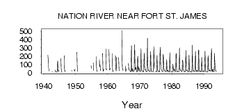
| PointID: | 864 | Code: | 07ED001 | Latitude (decimal degrees): | 55.20 | Longitude (decimal degrees): | -124.23 | Drainage Area (km2): | 4350.00 | Source: | Hydat | Hydrological Zone: | Mackenzie | Name: | NATION RIVER NEAR FORT ST. JAMES |
|---|
| Download | |
|---|---|
| Site Descriptor Information | Site Time Series Data |
| Link to all available data | |
| ID | Year | Jan | Feb | Mar | Apr | May | Jun | Jul | Aug | Sep | Oct | Nov | Dec |
|---|---|---|---|---|---|---|---|---|---|---|---|---|---|
| 864 | 1941 | 209.00 | 161.00 | 58.30 | 22.00 | 52.50 | |||||||
| 864 | 1942 | 193.00 | 10.40 | 13.70 | |||||||||
| 864 | 1943 | 31.20 | 14.80 | 13.10 | 11.00 | 8.00 | |||||||
| 864 | 1944 | 10.00 | 10.00 | 8.00 | 15.00 | 125.00 | 143.00 | 49.50 | 23.00 | 13.80 | 28.10 | ||
| 864 | 1945 | 172.00 | 49.00 | 18.00 | 8.31 | 8.27 | |||||||
| 864 | 1946 | 206.00 | 61.20 | 27.90 | 14.20 | 24.60 | |||||||
| 864 | 1947 | 70.20 | |||||||||||
| 864 | 1948 | 29.50 | 22.00 | ||||||||||
| 864 | 1949 | 224.00 | 34.70 | 19.30 | 24.30 | 43.00 | |||||||
| 864 | 1950 | 248.00 | 78.50 | 30.70 | 13.50 | ||||||||
| 864 | 1954 | 85.00 | 54.00 | ||||||||||
| 864 | 1955 | 118.00 | 50.70 | 24.70 | |||||||||
| 864 | 1956 | 195.00 | 85.50 | 27.60 | 15.00 | 17.50 | |||||||
| 864 | 1957 | 157.00 | 72.70 | 98.80 | 66.60 | 28.30 | 26.00 | ||||||
| 864 | 1958 | 220.00 | 231.00 | 60.20 | 19.00 | 20.90 | 39.90 | 34.00 | |||||
| 864 | 1959 | 289.00 | 131.00 | 34.60 | 46.50 | 46.40 | |||||||
| 864 | 1960 | 283.00 | 129.00 | 32.70 | 33.10 | 49.00 | 57.00 | ||||||
| 864 | 1961 | 230.00 | 53.50 | 16.60 | 16.70 | 24.10 | |||||||
| 864 | 1962 | 207.00 | 98.50 | 36.20 | 20.80 | 146.00 | 188.00 | ||||||
| 864 | 1963 | 182.00 | 68.60 | 32.40 | 24.70 | 28.70 | |||||||
| 864 | 1964 | 509.00 | 150.00 | 78.60 | 32.30 | 36.90 | 32.00 | ||||||
| 864 | 1965 | 81.10 | 29.10 | 15.30 | 36.60 | 50.00 | |||||||
| 864 | 1966 | 113.00 | 41.70 | 50.80 | 30.00 | 28.00 | 25.00 | ||||||
| 864 | 1967 | 21.00 | 15.00 | 10.00 | 15.00 | 153.00 | 326.00 | 70.90 | 23.70 | 15.00 | 52.80 | 39.00 | 23.00 |
| 864 | 1968 | 17.00 | 16.00 | 17.00 | 17.00 | 188.00 | 339.00 | 138.00 | 41.70 | 34.90 | 50.80 | 68.00 | 38.00 |
| 864 | 1969 | 17.00 | 10.00 | 8.00 | 19.00 | 186.00 | 198.00 | 42.50 | 19.90 | 49.90 | 68.50 | 47.00 | 38.00 |
| 864 | 1970 | 21.00 | 16.00 | 14.00 | 13.00 | 114.00 | 293.00 | 79.40 | 45.30 | 27.90 | 27.20 | 22.00 | 14.00 |
| 864 | 1971 | 10.00 | 10.00 | 10.00 | 12.00 | 147.00 | 235.00 | 131.00 | 34.70 | 40.80 | 43.50 | 30.00 | 21.00 |
| 864 | 1972 | 14.00 | 12.00 | 12.00 | 16.00 | 123.00 | 415.00 | 134.00 | 69.80 | 26.60 | 27.30 | 32.00 | 23.00 |
| 864 | 1973 | 17.00 | 14.00 | 13.00 | 13.00 | 171.00 | 254.00 | 97.10 | 24.70 | 15.50 | 18.50 | 17.00 | 14.00 |
| 864 | 1974 | 12.00 | 11.00 | 11.00 | 13.00 | 129.00 | 315.00 | 173.00 | 48.70 | ||||
| 864 | 1975 | 16.00 | 11.00 | 9.00 | 10.00 | 124.00 | 208.00 | 83.00 | 31.40 | 21.10 | 16.20 | 19.00 | 19.00 |
| 864 | 1976 | 15.00 | 12.00 | 10.00 | 18.00 | 226.00 | 307.00 | 167.00 | 73.20 | 51.50 | 37.60 | 32.00 | 21.00 |
| 864 | 1977 | 15.00 | 13.00 | 11.00 | 20.00 | 222.00 | 188.00 | 98.20 | 44.60 | 26.40 | 27.30 | 27.00 | 18.00 |
| 864 | 1978 | 13.00 | 11.00 | 11.00 | 14.00 | 89.80 | 159.00 | 46.80 | 15.90 | 18.70 | 28.70 | 26.00 | 20.00 |
| 864 | 1979 | 15.00 | 11.00 | 8.00 | 9.00 | 113.00 | 241.00 | 84.40 | 26.90 | 16.90 | 16.40 | 13.00 | 12.00 |
| 864 | 1980 | 10.00 | 8.00 | 7.00 | 8.00 | 103.00 | 85.60 | 44.50 | 23.70 | 21.30 | 26.60 | 50.00 | 38.00 |
| 864 | 1981 | 25.00 | 15.00 | 12.00 | 16.00 | 216.00 | 234.00 | 66.50 | 21.20 | 10.40 | 14.00 | 17.00 | 17.00 |
| 864 | 1982 | 13.00 | 11.00 | 10.00 | 10.00 | 81.20 | 300.00 | 101.00 | 45.00 | 30.70 | 26.20 | 34.00 | 22.00 |
| 864 | 1983 | 17.00 | 14.00 | 13.00 | 20.00 | 152.00 | 148.00 | 113.00 | 54.00 | 28.10 | 20.80 | 20.00 | 14.00 |
| 864 | 1984 | 12.00 | 10.00 | 10.00 | 19.00 | 120.00 | 269.00 | 133.00 | 35.50 | 24.20 | 36.60 | 28.00 | 23.00 |
| 864 | 1985 | 15.00 | 10.00 | 9.00 | 11.00 | 107.00 | 210.00 | 78.10 | 22.00 | 16.10 | 18.00 | 15.00 | 10.00 |
| 864 | 1986 | 11.00 | 8.00 | 8.00 | 11.00 | 76.70 | 333.00 | 122.00 | 37.80 | 15.90 | 24.70 | 27.00 | 20.00 |
| 864 | 1987 | 16.00 | 16.00 | 14.00 | 18.00 | 169.00 | 260.00 | 80.00 | 26.00 | 14.90 | 13.70 | 30.00 | 30.00 |
| 864 | 1988 | 19.00 | 16.00 | 14.00 | 21.00 | 260.00 | 276.00 | 74.00 | 29.70 | 14.10 | 17.30 | 23.00 | 19.00 |
| 864 | 1989 | 15.00 | 12.00 | 10.00 | 23.00 | 186.00 | 125.00 | 47.00 | 22.10 | 12.60 | 13.00 | 24.00 | 24.00 |
| 864 | 1990 | 21.00 | 15.00 | 14.00 | 22.00 | 183.00 | 261.00 | 67.30 | 23.00 | 12.60 | 11.00 | 12.00 | 10.00 |
| 864 | 1991 | 8.00 | 10.00 | 9.00 | 17.00 | 208.00 | 161.00 | 61.40 | 19.50 | 22.40 | 30.80 | 34.00 | 26.00 |
| 864 | 1992 | 22.00 | 19.00 | 20.00 | 65.00 | 221.00 | 293.00 | 71.90 | 14.90 | 11.30 | 39.70 | 46.00 | 27.00 |
| 864 | 1993 | 16.00 | 12.00 | 11.00 | 21.00 | 233.00 | 145.00 | 79.30 | 55.60 | 33.50 | 19.90 | 22.00 | 18.00 |
 Return to R-Arctic Net Home Page