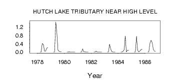
| PointID: | 813 | Code: | 07OB007 | Latitude (decimal degrees): | 58.71 | Longitude (decimal degrees): | -117.24 | Drainage Area (km2): | 103.00 | Source: | Hydat | Hydrological Zone: | Mackenzie | Name: | HUTCH LAKE TRIBUTARY NEAR HIGH LEVEL |
|---|
| Download | |
|---|---|
| Site Descriptor Information | Site Time Series Data |
| Link to all available data | |
| ID | Year | Jan | Feb | Mar | Apr | May | Jun | Jul | Aug | Sep | Oct | Nov | Dec |
|---|---|---|---|---|---|---|---|---|---|---|---|---|---|
| 813 | 1977 | 4.0e-03 | |||||||||||
| 813 | 1978 | 0.00 | 0.00 | 0.41 | 0.36 | 0.05 | 0.04 | 0.19 | 0.21 | ||||
| 813 | 1979 | 0.00 | 0.00 | 1.45 | 0.92 | 0.10 | 0.03 | 0.02 | 0.01 | ||||
| 813 | 1980 | 0.00 | 0.00 | 6.0e-03 | 1.0e-03 | 0.00 | 0.00 | 0.00 | 0.00 | ||||
| 813 | 1981 | 0.00 | 0.00 | 0.15 | 0.01 | 0.01 | 0.00 | 0.00 | 3.0e-03 | ||||
| 813 | 1982 | 0.00 | 0.00 | 0.04 | 4.0e-03 | 0.00 | 4.0e-03 | 0.00 | 0.00 | ||||
| 813 | 1983 | 0.00 | 0.00 | 0.38 | 0.14 | 0.02 | 3.0e-03 | 1.0e-03 | 1.0e-03 | ||||
| 813 | 1984 | 0.00 | 0.00 | 0.03 | 0.11 | 0.77 | 0.01 | 0.09 | 0.08 | ||||
| 813 | 1985 | 0.00 | 0.00 | 0.76 | 0.08 | 0.01 | 0.05 | 0.11 | 0.13 | ||||
| 813 | 1986 | 0.00 | 0.00 | 0.43 | 0.57 | 0.44 | 0.13 | 0.04 | 0.04 |
 Return to R-Arctic Net Home Page