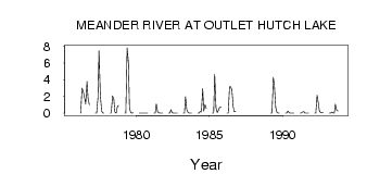
| PointID: | 811 | Code: | 07OB005 | Latitude (decimal degrees): | 58.77 | Longitude (decimal degrees): | -117.38 | Drainage Area (km2): | 507.00 | Source: | Hydat | Hydrological Zone: | Mackenzie | Name: | MEANDER RIVER AT OUTLET HUTCH LAKE |
|---|
| Download | |
|---|---|
| Site Descriptor Information | Site Time Series Data |
| Link to all available data | |
| ID | Year | Jan | Feb | Mar | Apr | May | Jun | Jul | Aug | Sep | Oct | Nov | Dec |
|---|---|---|---|---|---|---|---|---|---|---|---|---|---|
| 811 | 1975 | 0.45 | |||||||||||
| 811 | 1976 | 0.00 | 3.00 | 2.58 | 1.99 | 1.10 | 3.80 | 1.80 | 0.99 | ||||
| 811 | 1977 | 0.00 | 0.00 | 1.85 | 7.47 | 2.29 | 0.22 | 9.0e-03 | 0.02 | ||||
| 811 | 1978 | 0.00 | 0.00 | 2.07 | 1.67 | 0.14 | 0.01 | 0.78 | 0.93 | ||||
| 811 | 1979 | 0.00 | 0.00 | 7.83 | 6.11 | 0.63 | 0.03 | 0.02 | 0.05 | ||||
| 811 | 1980 | 0.00 | 0.00 | 0.01 | 2.0e-03 | 0.00 | 1.0e-03 | 0.00 | 0.00 | ||||
| 811 | 1981 | 0.00 | 0.00 | 1.10 | 0.18 | 0.03 | 0.01 | 1.0e-03 | 0.00 | ||||
| 811 | 1982 | 0.00 | 0.00 | 0.43 | 0.04 | 5.0e-03 | 0.00 | 0.00 | 3.0e-03 | ||||
| 811 | 1983 | 0.00 | 0.00 | 1.97 | 0.40 | 0.06 | 0.01 | 4.0e-03 | 5.0e-03 | ||||
| 811 | 1984 | 0.00 | 0.00 | 0.20 | 0.13 | 2.95 | 0.26 | 1.02 | 0.58 | ||||
| 811 | 1985 | 0.00 | 0.00 | 4.68 | 0.64 | 0.08 | 0.37 | 0.71 | 0.77 | ||||
| 811 | 1986 | 0.00 | 0.00 | 3.17 | 3.17 | 2.81 | 0.79 | 0.17 | 0.22 | ||||
| 811 | 1989 | 0.00 | 0.00 | 4.28 | 3.37 | 0.71 | 0.07 | 1.0e-03 | 0.00 | ||||
| 811 | 1990 | 0.00 | 0.00 | 0.27 | 0.03 | 8.0e-03 | 3.0e-03 | 0.00 | 3.0e-03 | ||||
| 811 | 1991 | 0.00 | 0.00 | 0.12 | 0.19 | 0.01 | 5.0e-03 | 3.0e-03 | 1.0e-03 | ||||
| 811 | 1992 | 0.00 | 0.00 | 2.15 | 1.16 | 0.23 | 0.07 | 0.04 | 0.08 | ||||
| 811 | 1993 | 0.00 | 0.00 | 0.15 | 0.05 | 7.0e-03 | 1.06 | 0.35 | 0.26 |
 Return to R-Arctic Net Home Page