| PointID: | 792 | Code: | 07JC002 | Latitude (decimal degrees): | 56.54 | Longitude (decimal degrees): | -115.23 | Drainage Area (km2): | 619.00 | Source: | Hydat | Hydrological Zone: | Mackenzie | Name: | REDEARTH CREEK NEAR RED EARTH CREEK |
|---|
| Download | |
|---|---|
| Site Descriptor Information | Site Time Series Data |
| Link to all available data | |
| ID | Year | Jan | Feb | Mar | Apr | May | Jun | Jul | Aug | Sep | Oct | Nov | Dec |
|---|---|---|---|---|---|---|---|---|---|---|---|---|---|
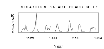
| 792 | 1987 | 0.00 | 1.00 | 1.90 | 2.58 | 0.79 | 4.39 | 1.01 | 0.60 | ||||
| 792 | 1988 | 0.00 | 1.00 | 1.77 | 3.95 | 11.20 | 1.47 | 0.14 | 0.37 | ||||
| 792 | 1989 | 0.00 | 0.00 | 3.17 | 4.21 | 1.28 | 2.39 | 1.33 | 3.40 | ||||
| 792 | 1990 | 0.00 | 2.00 | 5.22 | 3.70 | 1.53 | 0.07 | 0.14 | 0.21 | ||||
| 792 | 1991 | 0.00 | 0.00 | 0.38 | 6.91 | 5.09 | 0.62 | 2.38 | 0.63 | ||||
| 792 | 1992 | 0.00 | 4.00 | 4.52 | 3.35 | 0.28 | 0.03 | 0.12 | 0.22 | ||||
| 792 | 1993 | 0.00 | 0.00 | 2.95 | 1.43 | 3.06 | 2.52 | 2.32 | 1.53 |
 Return to R-Arctic Net Home Page