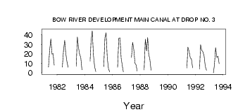
| PointID: | 79 | Code: | 05AC902 | Latitude (decimal degrees): | 50.15 | Longitude (decimal degrees): | -112.53 | Drainage Area (km2): | Source: | Hydat | Hydrological Zone: | Nelson | Name: | BOW RIVER DEVELOPMENT MAIN CANAL AT DROP NO. 3 |
|---|
| Download | |
|---|---|
| Site Descriptor Information | Site Time Series Data |
| Link to all available data | |
| ID | Year | Jan | Feb | Mar | Apr | May | Jun | Jul | Aug | Sep | Oct | Nov | Dec |
|---|---|---|---|---|---|---|---|---|---|---|---|---|---|
| 79 | 1981 | 6.13 | 24.00 | 35.80 | 19.60 | 20.20 | 8.02 | ||||||
| 79 | 1982 | 5.91 | 23.80 | 34.10 | 20.90 | 12.00 | 5.86 | ||||||
| 79 | 1983 | 7.03 | 37.70 | 27.50 | 19.70 | 16.30 | 3.30 | ||||||
| 79 | 1984 | 12.20 | 33.40 | 44.30 | 18.80 | 6.61 | 1.29 | ||||||
| 79 | 1985 | 6.58 | 37.00 | 42.20 | 15.50 | 4.51 | 0.99 | ||||||
| 79 | 1986 | 5.72 | 36.30 | 36.80 | 15.60 | 7.35 | 1.07 | ||||||
| 79 | 1987 | 16.20 | 32.10 | 24.30 | 9.95 | 8.56 | 1.75 | ||||||
| 79 | 1988 | 3.00 | 35.40 | 23.10 | 37.20 | 19.60 | 14.10 | 2.67 | |||||
| 79 | 1991 | 4.94 | 27.10 | 22.60 | 15.90 | 14.40 | 5.27 | ||||||
| 79 | 1992 | 4.00 | 29.50 | 23.50 | 22.10 | 17.50 | 6.71 | 2.65 | |||||
| 79 | 1993 | 0.00 | 8.41 | 26.60 | 16.30 | 17.50 | 9.62 |
 Return to R-Arctic Net Home Page