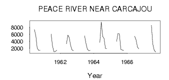
| PointID: | 786 | Code: | 07HD001 | Latitude (decimal degrees): | 57.74 | Longitude (decimal degrees): | -117.03 | Drainage Area (km2): | 210000.00 | Source: | Hydat | Hydrological Zone: | Mackenzie | Name: | PEACE RIVER NEAR CARCAJOU |
|---|
| Download | |
|---|---|
| Site Descriptor Information | Site Time Series Data |
| Link to all available data | |
| ID | Year | Jan | Feb | Mar | Apr | May | Jun | Jul | Aug | Sep | Oct | Nov | Dec |
|---|---|---|---|---|---|---|---|---|---|---|---|---|---|
| 786 | 1960 | 7360.00 | 5500.00 | 2080.00 | 1430.00 | 1480.00 | |||||||
| 786 | 1961 | 6090.00 | 2600.00 | 1030.00 | 1080.00 | 1430.00 | |||||||
| 786 | 1962 | 3270.00 | 5800.00 | 5060.00 | 2780.00 | 1560.00 | 1360.00 | ||||||
| 786 | 1963 | 5580.00 | 3530.00 | 1790.00 | 1330.00 | 1410.00 | |||||||
| 786 | 1964 | 3640.00 | 9530.00 | 5390.00 | 4870.00 | 1960.00 | 1960.00 | ||||||
| 786 | 1965 | 3980.00 | 6230.00 | 6140.00 | 1720.00 | 1540.00 | 1400.00 | ||||||
| 786 | 1966 | 5490.00 | 4420.00 | 2340.00 | 1890.00 | ||||||||
| 786 | 1967 | 8570.00 | 3270.00 | 1470.00 | 944.00 |
 Return to R-Arctic Net Home Page