| PointID: | 781 | Code: | 07HB001 | Latitude (decimal degrees): | 56.48 | Longitude (decimal degrees): | -116.43 | Drainage Area (km2): | 881.00 | Source: | Hydat | Hydrological Zone: | Mackenzie | Name: | CADOTTE RIVER AT OUTLET CADOTTE LAKE |
|---|
| Download | |
|---|---|
| Site Descriptor Information | Site Time Series Data |
| Link to all available data | |
| ID | Year | Jan | Feb | Mar | Apr | May | Jun | Jul | Aug | Sep | Oct | Nov | Dec |
|---|---|---|---|---|---|---|---|---|---|---|---|---|---|
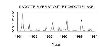
| 781 | 1984 | 0.00 | 0.00 | 2.49 | 6.62 | 9.78 | 1.48 | 0.09 | 0.18 | ||||
| 781 | 1985 | 0.00 | 1.00 | 4.59 | 0.66 | 0.01 | 3.0e-03 | 1.0e-03 | 1.0e-03 | ||||
| 781 | 1986 | 0.00 | 0.00 | 0.53 | 0.04 | 0.49 | 0.04 | 5.0e-03 | 4.0e-03 | ||||
| 781 | 1987 | 0.00 | 0.00 | 0.34 | 0.04 | 0.01 | 1.79 | 1.38 | 0.22 | ||||
| 781 | 1988 | 0.00 | 0.00 | 1.36 | 2.50 | 5.08 | 0.97 | 0.01 | 0.01 | ||||
| 781 | 1989 | 0.00 | 0.00 | 2.34 | 0.77 | 0.12 | 0.07 | 0.08 | 0.90 | ||||
| 781 | 1990 | 0.00 | 1.00 | 4.99 | 5.91 | 0.54 | 6.0e-03 | 3.0e-03 | 3.0e-03 | ||||
| 781 | 1991 | 0.00 | 0.00 | 9.0e-03 | 6.0e-03 | 2.0e-03 | 0.00 | 0.00 | 0.00 | ||||
| 781 | 1992 | 0.00 | 3.00 | 6.00 | 3.18 | 1.34 | 0.02 | 0.02 | 0.09 | ||||
| 781 | 1993 | 0.00 | 0.00 | 0.30 | 0.04 | 1.12 | 0.23 | 0.08 | 0.22 |
 Return to R-Arctic Net Home Page