Orkhon-Hara-Hara
Yenisei
| PointID: | 7732 |
Code: | Mo005 |
Latitude (decimal degrees): | 48.55 |
Longitude (decimal degrees): | 106.04 |
Drainage Area (km2): | |
Source: | SHI |
Hydrological Zone: | Yenisei |
Name: | Orkhon-Hara-Hara |
Field Definitions
Site Time Series Plot:
Site Data File:
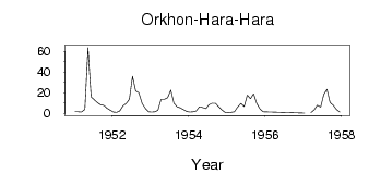
(Units: m3/s)
| ID | Year | Jan | Feb | Mar | Apr | May | Jun | Jul | Aug | Sep | Oct | Nov | Dec |
|---|
| 7732 | 1951 | 1.49 | 1.37 | 1.25 | 3.73 | 63.60 | 15.80 | 13.10 | 10.30 | 8.27 | 7.42 | 4.60 | 3.01 |
| 7732 | 1952 | 1.16 | 0.80 | 2.13 | 7.35 | 9.43 | 13.70 | 36.00 | 21.80 | 19.90 | 9.34 | 4.66 | 1.47 |
| 7732 | 1953 | 1.14 | 1.44 | 3.00 | 13.60 | 13.60 | 15.20 | 22.50 | 9.69 | 6.15 | 5.32 | 3.50 | 1.63 |
| 7732 | 1954 | 1.25 | 1.33 | 2.29 | 6.33 | 5.37 | 4.48 | 8.20 | 9.80 | 9.70 | 6.47 | 3.21 | 0.81 |
| 7732 | 1955 | 0.35 | 0.84 | 1.39 | 6.11 | 9.49 | 6.55 | 17.70 | 14.20 | 18.80 | 9.49 | 3.87 | 1.50 |
| 7732 | 1957 | 0.08 | | 0.61 | 3.31 | 7.83 | 6.00 | 18.30 | 23.20 | 10.20 | 7.73 | 3.63 | 1.29 |
 Return to R-Arctic Net Home Page