Lakselv-Mevath
Scandinavia
| PointID: | 7729 |
Code: | NO017 |
Latitude (decimal degrees): | 69.23 |
Longitude (decimal degrees): | 17.78 |
Drainage Area (km2): | 178.00 |
Source: | SHI |
Hydrological Zone: | Scandinavia |
Name: | Lakselv-Mevath |
Field Definitions
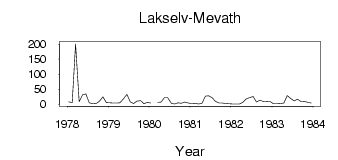
Site Time Series Plot:
Site Data File:
(Units: m3/s)
| ID | Year | Jan | Feb | Mar | Apr | May | Jun | Jul | Aug | Sep | Oct | Nov | Dec |
|---|
| 7729 | 1978 | 8.48 | 5.22 | 201.00 | 8.91 | 30.91 | 34.45 | 5.26 | 1.54 | 2.13 | 10.77 | 24.79 | 5.59 |
| 7729 | 1979 | 5.23 | 3.75 | 4.37 | 4.77 | 18.60 | 33.16 | 7.91 | 2.15 | 10.63 | 12.28 | 1.73 | 6.38 |
| 7729 | 1980 | 4.20 | | 6.19 | 7.43 | 21.32 | 22.07 | 3.40 | 0.98 | 4.75 | 3.07 | 7.69 | 3.76 |
| 7729 | 1981 | 2.23 | 3.26 | 0.90 | 3.33 | 27.31 | 27.93 | 21.54 | 9.40 | 3.91 | 4.18 | 2.44 | 1.97 |
| 7729 | 1982 | 1.13 | 0.83 | 0.65 | 6.16 | 17.78 | 22.73 | 25.68 | 7.45 | 13.55 | 9.21 | 9.45 | 8.86 |
| 7729 | 1983 | 1.59 | 1.95 | 2.27 | 3.82 | 28.72 | 19.58 | 11.11 | 16.78 | 9.11 | 9.66 | 6.20 | 3.85 |
 Return to R-Arctic Net Home Page